| Mapping, GIS, & Transportation Software Solutions |
| Mapping, GIS, & Transportation Software Solutions |
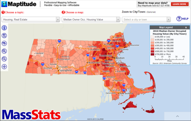
MassStats.com:
MassStats.com allows Massachusetts residents to explore the issues
that impact their community, gathered from a variety of
disparate and normally unintegrated sources.
Mapping and big data are hot topics right now, but real-world public facing resources that easily convey this information are few.
If you find it fascinating it may well be fascinating to a broad audience. Google Earth’s main function is as an aerial photo viewer that people often use to see their house and neighborhood. MassStats takes this a step further and allows you to see the fabric of your community and how it compares to other communities. This is provided in a relatable map-based format.
The fact that we are also an Massachusetts GIS company helps to keep the focus local but interesting, especially given our impact on national mapping:
•
http://www.bizjournals.com/boston/blog/mass-high-tech/2009/05/caliper-adds-to-new-england-mapping-software.html
•
https://www.caliper.com/PDFs/how-maptitude-wins-big-mapping-battles.pdf
Skewed Reporting on Aisle-Neutral Software: How mapping has actually democratized redistricting
Maptitude for
Redistricting has received mentions in Rolling Stone, Dallas Morning
News, Boston Globe, The Atlantic, The Atlantic Cities, The New York Times,
and many other media
outlets. Maptitude for Redistricting is used by a supermajority of the
state legislatures, political parties, and public interest groups of both
political parties in support of political boundary drawing.
A fully transparent and open process is required to produce boundaries worthy of a democratic process. This article explores the reality of how technology is used in redistricting. We are available to work with you on how mapping tech can be leveraged for good in politics
Discussion Piece:
There has been a great deal of press on Microsoft
recently with its acquisition of NOKIA, while also becoming a strategic licensee of the
HERE/NAVTEQ mapping data. However, the flagship
Microsoft mapping product, MapPoint,
continues to provide pre-2010 Census data, while
Maptitude includes the latest annual updates to
nationwide demographics from the Census and ACS.
•
Maptitude Census Data Mapping
•
Maptitude vs. MapPoint Review
•
Microsoft MapPoint Forum
Map Infographics:
•
Maptitude Featured Maps
Since 1995 Maptitude has been helping businesses of all
sizes cost-effectively realize the benefits of
location-based analysis normally limited to large
corporations. Maptitude provides a way to extend the
capabilities of all business analysts. With a focus on
usability, Maptitude has consistently been labeled as
the easiest-to-use professional mapping software (read
reviews here.)
•
How Maptitude Wins Big Mapping Battles
•
A Mapping Solution for Business
• The Easiest Way to Make Maps

Talking Points:
Maptitude has influenced the lives of every citizen of
the United States and supports the bedrock of our
democracy through a broad range of programs that
encompass elections, community services, infrastructure,
and business planning. The versatility of the software
has saved taxpayer dollars and continues to improve the
operational efficiency of the country.
| • | How Maptitude wins big mapping battles |
| • | Caliper Creates Software for Five Major U.S. Census Data Programs |
Home | Products | Contact | Secure Store