TransCAD ObjectsOnly TransCAD provides completely integrated GIS and transportation analysis
TransCAD extends the traditional GIS data model to include transportation data objects such as:
These extensions make TransCAD the best data management and analysis tool for working with transportation data. You can use the GIS functions to prepare, visualize, analyze, and present your work, and use the application modules to solve routing, logistics, and other transportation problems with greater ease and efficiency than with any other product. Networks and matrices can be of virtually unlimited size. Transportation Networks are specialized data structures that govern flow over a network. Networks are stored in a highly-efficient way, enabling TransCAD to solve routing problems very quickly. Networks can include detailed characteristics such as:
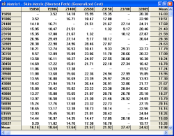
Matrices
hold data such as distance, travel times, and origin-destination flows
that are essential for many transportation applications. TransCAD
provides functions for creating and manipulating matrices, and tools for
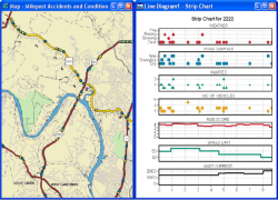
spatial analysis and advanced visualization of matrix data. This
combination lets you see and understand transportation flows and network
characteristics in new and different ways.
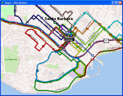
Routes and Route Systems indicate paths taken by
trucks, rail, cars, buses, or individuals traveling from place to place.
TransCAD includes tools to create, display, edit, and manipulate routes,
and unique display technology for mapping routes in a clear and
compelling fashion. You can organize a set of related routes into a
single route system layer, and include route attributes, stop locations,
and vehicle schedules.
|