Census tracts are a small, relatively permanent statistical subdivision of a county delineated by a local committee of census data users for the purpose of presenting census data. Census tract boundaries normally follow visible features, but may follow governmental unit boundaries and other non-visible features, and they always nest within counties. Census tracts are designed to be relatively homogenous units with respect to population characteristics, economic status, and living conditions at the time the users established them. They usually contain 1,500 to 8,000 people and are made up of on average about four block groups. There are about 66,000 tracts nationwide.
When you purchase Maptitude mapping software with the U.S. Country Package, it includes nationwide tract boundaries with dozens of demographic variables so that you can create insightful and informative maps at a neighborhood level anywhere in the United States. With a few clicks of the mouse, you can create thematic maps that will allow you to quickly analyze data for your area of interest. In addition, Maptitude includes a number of predesigned tract level maps in a Map Library.
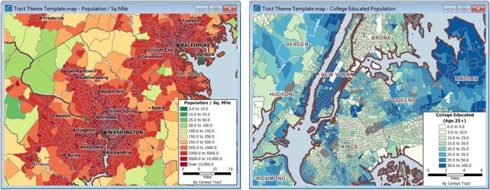
Tract level maps of population density in Washington DC and level of education in New York City.
The tract level data is also ideal for estimating demographics for your own geographic areas. For example, use the tract level data to estimate the demographics within five miles of store locations so you can compare the populations and look for correlations with sales data.
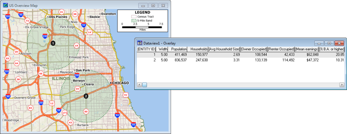
The map shows five-mile bands around two sites in Chicago. The dataview shows their estimated attributes based on the tract level data. About twice as many people live within five miles of the 2nd site and the mean earnings are about 33% higher for people living within five miles of the 1st site.
Home | Products | Contact | Secure Store
