Maptitude makes it easy to use maps to analyse and understand the best locations for retail site selection, hotel site selection, or any other facility placement problem. Maptitude is a powerful combination of site mapping software and geographic data that provides everything that you need to make informed decisions.
In addition to the latest demographics, Maptitude includes substantial social, housing, and income data, along with easy-to-use suitability analysis tools that will allow you to better understand the relationships between your demand, supply, and competitor locations.
| Facility Site Selection Highlights |
|---|
|

In addition to the site selection tools below, Maptitude has extensive functionality for Marketing and Sales Mapping including travel time rings.
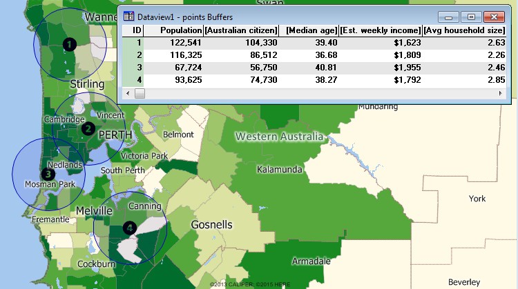
Perform site selection analysis using the included data to analyse the demographics about any number of sites to find the ones with the most desirable characteristics.

|
“Maptitude is excellent for doing geographic analysis projects looking at: where existing customers are and new ones might be (including using the built-in demographic data); identifying hot-spots, patterns and trends that can't be seen in Excel. It is really helpful with network design tasks - which sites are best: centers of gravity; visualizing size of flows between distribution centers; allocating volume to different depots.” Kirsten Tisdale |
The retail site location process is not simply a matter of identifying available properties. It requires a series of analytical steps that GIS software is ideally suited to help answer:
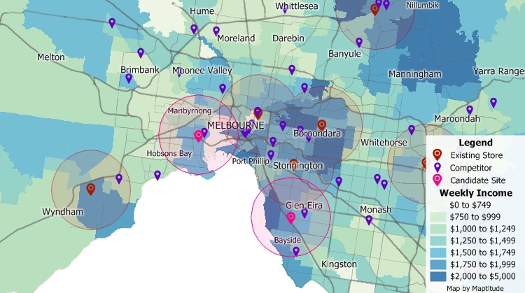
By using GIS in the retail site selection process you can assess a site's competitive pressures, accessibility, and market potential.
 CASE STUDY:

|
“I have access to traffic counts, local businesses, demographic information, drive times, and aerial imagery, all at the tips of my fingers. The program is easy to use, as well.” Kellye Martin |
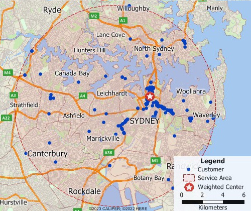
Find a weighted center of service for a collection of locations to identify valuable sites.
With Maptitude you can create a circular service area that encompasses a set of points such as addresses. You can then choose to weight the center location by a field in your point layer such as demand.
Find a weighted center of service for a collection of locations to identify valuable sites.
For example, if you are considering relocating a store, you can create a trade area around your customers and weight the center by their sales volume to determine a new candidate location. Alternatively, you may have a database of client employees. You can then use Maptitude to see the best central location based on the density and distribution of the addresses. These could be weighted by seniority, allowing you to better explore potential site locations by considering staff characteristics.
There is also a Facility Location wizard for site selection analysis (see Facility Location below). The Wizard provides a powerful yet simple to use site selection tool that guides you through the entire site selection process from model creation to site prediction.
In addition, street-based tools allow you to create drive-time rings that give you an additional method for assessing the accessibility of a site. You can use the rings to determine areas that are underserved or to determine how many of your customers would benefit from a new site with shorter drive times.
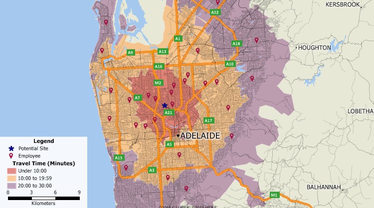
Determine the proximity of your employees or customers based on the drive time to different sites.

|
“Maptitude is a great alternative to [other mapping software]. Using Maptitude, I can easily create 3-D maps, heat/hot spot mapping, Areas of Influence (Thiessen Polygons), drive-time rings, flow maps (desire lines and spider maps), territory mapping, and spatial overlays (tagging features from one layer to another), trade area/site selection and much more.” Brett Lucas |
Facility location problems involve choosing the best location for one or more facilities from a set of possible locations. Potential applications include exploring new franchise locations, corporate office relocations, and branch optimization. The included site location toolset addresses all types of site location preferences. For example:
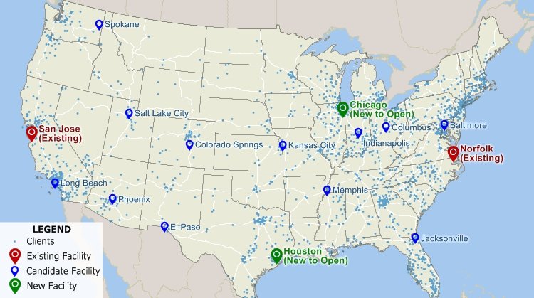
Facility location models can identify efficient sites, taking into account both existing facilities and candidate locations.

|
“The Facility Location tool is a gem offering a wide range of opportunities for relocation purposes.” Paul Lucassen |
(1)https://www2.deloitte.com/us/en/pages/operations/articles/twelve-mistakes-to-avoid-site-selection-process.html
(2)https://www.buxtonco.com/blog/the-ultimate-guide-to-retail-site-selection
Home | Products | Contact | Secure Store
