Maptitude allows you to quickly and easily map your data to produce high quality, attractive, and professional map graphics.
Maptitude maps can be saved to a wide variety of image formats both vector and raster, such as PNG and Jpeg. You can also share your maps online and save your maps as a PDF. You have full control over image quality and resolution, allowing you to create crisp and clear graphics.
Maptitude has a full suite of report tools, with a layout page that allows you to move and align items, and to choose the placement for multiple graphics, and to directly edit and draw on the page or pages. Printers, paper size, and margins can all be customized.
The list of the types of maps you can create is endless. Starting from the high quality cartographic maps accessible from the Maptitude Map Librarian or Create-a-Map Wizard, you can make a map for any purpose or audience. Maps can be at the local level to the national or global. You can creates maps for sales, territories, delivery routes, walking paths, environmental assessment, planning, marketing, site analysis, and many more.
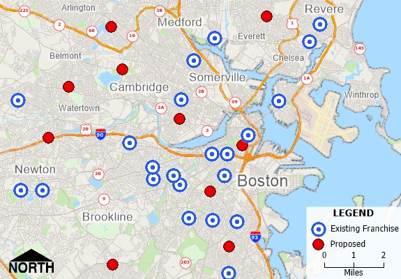
Map created with Maptitude SmartDraw replacement
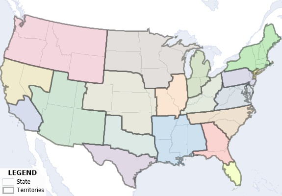
Balanced territory map created with Maptitude SmartDraw alternative
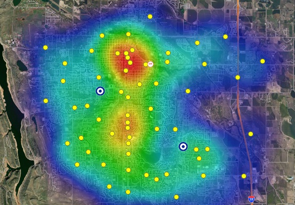
The Maptitude SmartDraw alternative includes analysis tools for heat maps, buffers, facility location, and more
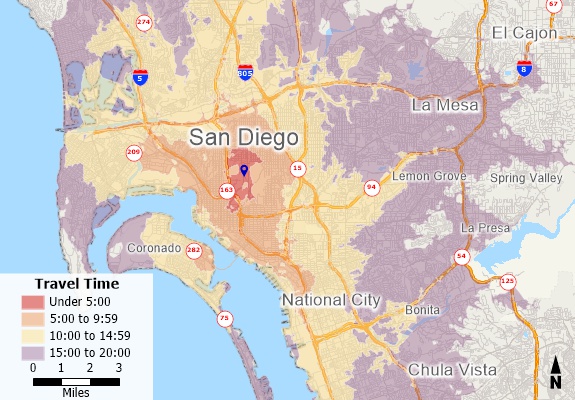
Maptitude includes routing and drive-time tools making it an ideal alternative to SmartDraw
 Presenting Tangible Data for Decision Making
The San Antonio Kidney Disease Center needed to see where patients lived based on different criteria and sometimes on subsets of that criteria. They needed to be able to contrast one set versus another very quickly and they needed a simple way for the physicians to be able to use the data |
 “I
have been a planning consultant for over 20 years. I highly
recommend Maptitude. The learning curve is short - it is the
most intuitive but powerful mapping application I have ever
used. Others are fine, they cannot beat the ease of use and
functionality of Maptitude. It is easy to create map layers and
final presentation maps from scratch with it. And Maptitude
comes with map layer data of its own, which is the best I have
seen. In addition can import a variety of file types,
which is extremely valuable when you are working with local
governments using a variety of map formats. This means
you can readily combine data from many sources in one map in
Maptitude. You will really like working with it.”
“I
have been a planning consultant for over 20 years. I highly
recommend Maptitude. The learning curve is short - it is the
most intuitive but powerful mapping application I have ever
used. Others are fine, they cannot beat the ease of use and
functionality of Maptitude. It is easy to create map layers and
final presentation maps from scratch with it. And Maptitude
comes with map layer data of its own, which is the best I have
seen. In addition can import a variety of file types,
which is extremely valuable when you are working with local
governments using a variety of map formats. This means
you can readily combine data from many sources in one map in
Maptitude. You will really like working with it.”
Taunya Kopke
President, Kopke & Associates, Inc.
 “Maptitude
is an incredibly powerful program for a very competitive price.
The integration of census data and the ease of using your own
data make an incredibly useful program. They are
continually adding new and free data points to the included data. If
you need to visualize data on a map this is the program to get.”
“Maptitude
is an incredibly powerful program for a very competitive price.
The integration of census data and the ease of using your own
data make an incredibly useful program. They are
continually adding new and free data points to the included data. If
you need to visualize data on a map this is the program to get.”
Colleen Boyle
LABORERS International of North America
Learn more about Maptitude to see how you and your team can access the data critical to making successful business decisions!
 Check out our G2 Reviews
Home | Products | Contact | Secure Store
