GIS logistics tools are critical to a company’s success. Research shows that companies using sophisticated supply chain methods achieve profit levels 12 times greater than those with less sophisticated solutions.1 Caliper Corporation's Maptitude and TransCAD logistics mapping software include tools for solving all types of routing applications such as:
Maptitude alternative to Geoconcept TourSolver can plan door-to-door delivery and pickup
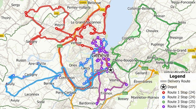
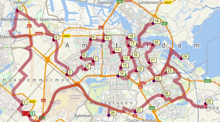
Maptitude can be used for planning deliveries that account for vehicle capacities, time windows, multiple depots, and more
TransCAD includes arc routing tools for street sweeping, meter reading, and other applications making it an ideal Geoconcept TourSolver replacement
How Aricia uses the Cost-Effective Maptitude GIS for
Logistics Network Development
Read more...
Maptitude Only US$695
Français

|
“Maptitude offers a diverse array of analytical tools at an affordable price. It is a comprehensive and the most affordable GIS software available on the market. Maptitude is a standalone product and comes fully loaded. Apart from the standard analytical tools, Maptitude offers extensive capabilities for analyzing competing businesses in a particular neighborhood using adjacency tools. It also performs route analysis to determine driving directions or delivery routes that minimize logistics costs.” Murtaza Haider |

|
“Maptitude is excellent for doing geographic analysis projects looking at: where existing customers are and new ones might be (including using the built-in demographic data); identifying hot-spots, patterns and trends that can't be seen in Excel. It is really helpful with network design tasks - which sites are best: centers of gravity; visualizing size of flows between distribution centers; allocating volume to different depots.” Kirsten Tisdale |
Additional procedures have broad applications in transportation and marketing. Clustering routines assemble customers, facilities, or areas into groups that are compact and can be serviced efficiently. Districting models group Census areas, ZIP Codes, counties, or other regions into territories that are compact and balanced. Location models evaluate the costs and benefits of any number of proposed facility locations. These models can be used for:
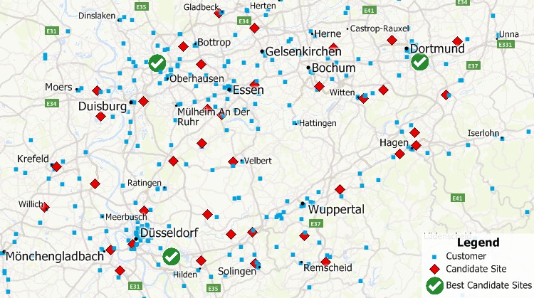
Identify the best location for one or more facilities from a set of possible locations using Maptitude Geoconcept TourSolver alternatives

Logistics software solutions for creating territories and territory alignment

|
“The Facility Location tool is a gem offering a wide range of opportunities for relocation purposes.” Paul Lucassen |
Please contact sales@caliper.com for more information on our logistics mapping software.
Home | Products | Contact | Secure Store
