By Kirsten Tisdale, Principal, Aricia Logistics Consulting - Aricia Ltd
A couple of clients have asked recently how I use GIS software for logistics network development, so I thought it would be useful to put together a case study, although my proviso is that every project is different and has its own review points and iterations. I use Maptitude which has some particularly useful features for this activity.
If you're in a service-oriented business, you may well have a good idea about how far from your customers each distribution location can be. Depending on order lead time, it may be possible to reduce the number of stockholding locations while still maintaining the required level of service. The needed service level will affect how far away your locations can be from the customers, which will, in turn, affect how many locations you will need. Maptitude is a cost-effective Geographic Information System (GIS) for exploring these logistics network development issues.
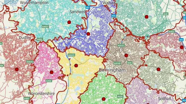
Start by placing customers as "spots on a map" or, if there are many across a wide area, then aggregated in some way, say at postcode district level. The information you import also needs to include data about number of deliveries, units and weight/volume over whatever time period you’re looking at.
By carrying out analysis of "ideal" locations based on customer geography, deliveries, units and weight or volume measures, you will end up with some indication of locations – probably some hotspot triangles based on the different centres of gravity indicated by the different measures.
At this point you might take a couple of different directions of practical analysis. Are the locations realistic? Consider where there is actual warehousing available, or in the pipeline, of the sort of type and size that will be appropriate for your business.
And look at the drive times – what will it be like to trunk between the various locations, and which customers might receive a lower level of service. With respect to drive time zones, the UK package for Maptitude contains HERE data and the road speeds are general traffic speeds for Wednesday lunchtime. If you’re working with trucks, you can either reduce the core speeds yourself or scale them back to reflect truck speeds, tweaking them to suit your own operation.
It's also worth considering your attitude to risk and business continuity with respect to the number of stockholding facilities. And if you’re in a value-oriented business it may be more important to you that your warehouse is located in an area of cheaper land prices as part of an overall cost-effective package, although it will still be important to have access to good pools of staff.
When you get to the point where you wish to cost out some scenarios, you can use the allocation of customers to locations to calculate volume, and from there the square footage, staffing and so on. Maptitude enables you to create batch distance files, which you can then use to calculate high level transport costs for the various options.
And you can carry out what-ifs. As well as looking at differing costs, if you're a growing business, how might that growth affect your decision as to the best place to locate? You can use the demographic data embedded in Maptitude to model what your geographic footprint might look like when you’ve got the same sort of market penetration across the country.
As I said at the start of this piece, this is just an outline - every project is different and has its own review points and iterations.
Caliper Corporation develops state-of-the-art Geographic Information Systems (GIS) and transportation software. Caliper is a privately-held corporation and is a leading developer of mapping, redistricting, transportation, and GIS software. Caliper is also a highly regarded consulting and R&D provider, offering professional services in quantitative management consulting, transportation, and decision support systems development. Caliper software products are supported with extensive technical services in GIS applications and training, database development, and software customization.
 “I use Maptitude mainly for strategic logistics studies, so for me the best features are things like: allocating drops to nearest depots, batch time and mileage calculations, volume flow lines, drivetime zones and the facility location tool.”
Kirsten Tisdale
Aricia Logistics Consulting
Kirsten has over thirty years' experience of logistics management and projects and combines strong analytical ability with an operational background. Prior to establishing Aricia in 2001, Kirsten managed logistics projects and operations at Marks & Spencer, PE, TNT, and DP DHL.
Maptitude includes an analysis tool for facility location with several options around whether there are any existing locations to be taken into consideration, and the number of new ones that you’re looking to consider.
This facility location tool works on road times/distance and operates at a single-level – distribution centre out to store, although it is possible to include supply into the DC also, by scaling that supply to reflect the balance of trunking to delivery cost. Even if you decide to only look at one level, this balance between trunking and delivery is a calculation that you will need to carry out to cost the output and is a key influencer.
You can also use another Maptitude analysis tool which will allow you, through a couple of steps, to allocate each customer to its closest depot. This will allow you to calculate the relative size of different locations. Now step back and consider if you need more facilities, or a different balance? This may be either because there are some key customers who are at the edge of the area that can be easily serviced or because you don’t want to put that much volume through one facility in the South East.
Home | Products | Contact | Secure Store