Maptitude for Redistricting 2020 includes a number of
redistricting improvements, enhancements, and new features including:
- Improved performance for critical tasks including importing and exporting plans, report generation and more.
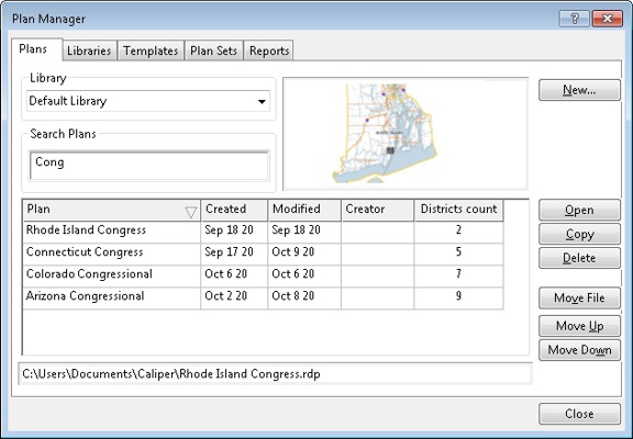
- The Plan Manager opens automatically on startup1
- An updated Plan Manager that:
- Includes additional information about each plan, including date created, plan creator and the number of districts
- Facilitates sorting plans based on plan name, date created, date modified, plan creator and the number of districts
- Filters plans based on multiple criteria that match plan name, date created, date modified, plan creator and the number of districts
- Has improved handling for moved plans and files
- A wizard for creating new plans that:
- Displays all methods for plan creation at the initial stage of plan creation
- Includes relevant help tips about each step in the wizard
- Automatically identifies the number of unique districts in an equivalency file or area layer when importing a plan
- Makes rearranging and removing summary fields simple
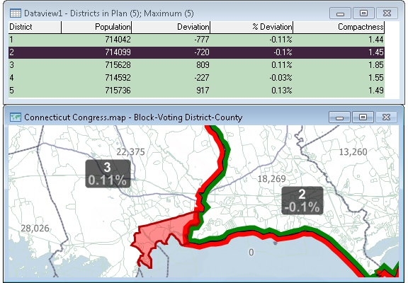
- Enhanced plan editing tools that:
- Includes District Name and % Deviation labels for each district by default
- Highlights the Target and Source districts on the map2
- Includes the Alternate Schwartzberg compactness measure for each district in the Districts dataview
- Broadens the Select by Rectangle tool to select features by clicking and by drawing a rectangle
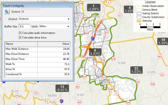
- Interactive Travel Contiguity analysis that determines the percentage of intersections in each district that can be reached by walking, driving, or in combination, without leaving the district
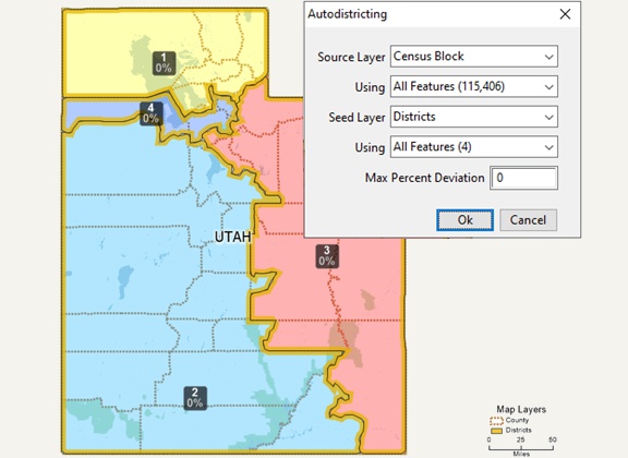
- An Automated Assistant that creates balanced compact plans around the seeds you provide so that you can make refinements as desired
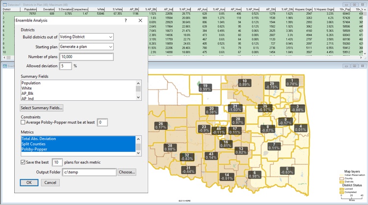
- Ensemble Analysis that automatically creates thousands of balanced, randomized plans against which you can measure your plan
- Expanded standard reports that incorporate the latest accepted redistricting measures:
- Fracking exposes the Counties, Minor Civil Divisions or Towns that have more than one non-contiguous piece in the same district
- Political Asymmetry measures that report Mean-Median Difference and Declination for political data3
- Cut edges method of compactness
- Travel Contiguity analysis that determines the percentage of intersections in each district that can be reached by walking, driving, or in combination, without leaving the district
- A plan library which includes enacted plans for each chamber, using each of the relevant hierarchies4
- Updated maps that include superior street geography and business data from HERE®
- A pre-calculated Plurality field for each area layer that indicates the ordered top three races/ethnicity for each feature
- A settings file that includes color themes for numerous race/ethnicity fields and plurality5
- A themes file for the Redistricting toolbox that facilitates displaying color themes for numerous race/ethnicity fields and plurality for any area layer6
Additional new Maptitude 2020 features are also
included:
- The most up-to-date geographic and demographic
information available, including improved
points-of-interest/landmarks.
- Speed improvements for layer drawing, drive-time
ring/contour/buffer tools, download times, and loading of
all the routing tools.
- Copy drawing items between maps to the exact same
location.
- Differentiate points on a map using a default numbered
symbol theme.
- A new export to PDF tool automatically saves your map to
either a landscape or portrait orientation, depending on the
dimensions of your map window
- Interoperability with external data has been expanded
with support for ERDAS Imagine and GeoJSON files, and for
Esri ArcGIS Pro. In addition, you can connect to external
services such as Microsoft Bing to analyze driving, public
transportation, or walking travel times, or real-time travel
by arrival time, departure time, and date.
- Interoperability with Maptitude has been expanded with
PostgreSQL functions, support for Intellisense in our
Microsoft Visual Studio add-on, and by documenting external
calls to the Update Linked Records tools via the API.
- Map your information whether you have data from Google
Maps, from a Microsoft mapping product such as MapPoint, or
from Microsoft Office. You can analyze your information
using the intuitive Maptitude 2020 mapping wizards and
export your results as attractive, preformatted Excel or PDF
reports.
- Exporting via File>Export>Table
defaults to the Excel (*.xlsx) file format
- Fewer files constitute the shipped Compact Geographic
File (*.cdf) format layers
- Larger Compact Geographic File (*.cdf) sizes are
supported, exceeding the previous 2 gigabyte limit
- Better compression is supported for the Compact
Geographic File (*.cdf) format resulting in smaller file
sizes
- Choosing Map>Linked Records Settings allows you to see
the layer, field, and file used in the Create-a-Map Wizard
“Link Data” step. Choosing Map>Update Linked Records allows
you to permanently change the linked file when, for example,
the file name has changed
- Updated sources for the Map>Imagery>USGS
Aerial Imagery and the
Map>Imagery>USGS Topographic Maps imagery
tools
- Supports a single 64-bit Maptitude installation file. If
you require 32-bit Maptitude, please contact us at sales@caliper.com
Click here to see features that were new to Maptitude for
Redistricting 2019
1Behavior can be changed in Edit>Preferences
2Behavior can be customized in Plan Settings>Map
3Political data are not included in Maptitude for Redistricting but are easily incorporated using the Copy Joined Fields command and/or Disaggregate/Aggregate Wizard
4Add the library, [StateName].rdl to take advantage of this feature
5Redistricting Settings.stg can be Loaded from the Color Theme dialog box
6rdthemes.bin can be copied to c:\users\[username]\Documents\Caliper\ for direct integration with the Redistricting toolbox