Live Demo

 Pricing 


Brochure

Our Clients

Testimonials

Contact us for more information & pricing

Maptitude for Redistricting Software

Maptitude for Redistricting includes everything you need to build and analyze redistricting plans.
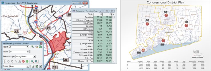
The custom menus and redistricting toolbox let you:

  • Organize plans, create any number of plan types, and save them as Plan Templates.
  • Create a new plan from a map, template, or existing plan.
  • Import and merge plans created with Maptitude for Redistricting or other redistricting software. You can also convert plans based on previous versions of TIGER geography to a plan using the latest geography without needing to first export to an equivalency file.
  • Add political data and election results. Use the Disaggregation/Aggregation Wizard to quickly disaggregate precinct-level election data down to Census Block geography and aggregate it up to higher levels of geography.
  • Designate the control field, number of districts, ideal value, and any number of summary fields.
  • Add areas to a target district using point, circle, lasso, and line selection tools or by attribute values. You can also select features in any geographic layer (e.g., block, voting district, county) and limit the selection to unassigned areas, one district, or the entire jurisdiction.
  • Easily manage districts: rename districts, handle multi-member districts, assign ID and long name to districts, lock districts, and mark them complete.
  • Capture the status of a plan as a snapshot and then use the snapshot as a departure point in the evolution of the plan.
  • Display attributes for any layer using labels, themes, and dataviews.
  • Display summary information in a table that contains the district identifier, control field totals, deviation from the ideal value, and the totals and percentages for summary fields.
  • Identify communities of interest and keep them intact within the same district or create reports calculating the percentage of the community in each of several districts.
  • Easily find unassigned areas and automatically assign them when completely surrounded by the same district.
  • List all noncontiguous portions of districts and easily assign them to the correct district
  • Compute measures of compactness, including the Reock, Schwartzberg, Perimeter, Polsby-Popper, Length-Width, Population Polygon, Population Circle, and Ehrenburg metrics, to assess or defend districts in a plan.
  • Export a plan to standard equivalency file formats.
  • Create a map book for some or all of the districts.
  • Integrate your plans with Google Maps and Google Earth.
  • Generate and print over 35 reports including population summary, error check, political subdivision splits, incumbents, plan statistics, plan components (bill language), plan comparison, and communities of interest, and group reports together in report sets.
  • Create custom reports and add them to the Report menu.

   Maptitude for Redistricting Plan

Works with Most Other GIS and Mapping Software

Maptitude supports over 50 file types and more than 100 GIS and CAD file formats allowing you to easily migrate your existing geographic data. You can map Esri Shapefiles, Geodatabases, MapInfo TAB files, and Oracle Spatial tables directly, or use the built-in translators to import geographic data from a variety of other software packages and public sources. This extensive library of importers and exporters is one of the largest in the industry and comes at no additional charge. You can export plans (geography and data) to these other formats if your GIS department uses one of these other products.

You can use raster images such as satellite or aerial photographs directly in your maps. Maptitude includes tools for quickly accessing online images from Microsoft Virtual Earth and Google Earth. You can use the images as a means of reference or in conjunction with the redistricting tools to draw your districts. 

Easy to Learn and Use

Maptitude for Redistricting includes online help and detailed manuals packed with step-by-step instructions and tutorials. The Plan Manager leads you through the process of creating your first plan and speeds the creation of all additional plans. Other wizards help you create maps, display data using meaningful themes, and geocode information based on street address. In addition, Caliper offers training at your site or at our headquarters in Newton, Massachusetts.

Complete Organizational Solution

With the Maptitude for Redistricting Plan Manager you can easily manage an unlimited number of plans stored on a computer network. You can quickly find a plan by type, creator, date, key word, etc. The Plan Manager lets you distribute plans for viewing and perform plan management functions across your organization. Data and plans can be stored on individual machines or on one central server with access controlled by both Maptitude for Redistricting and the network administration software.

System Requirements

Maptitude for Redistricting runs on Microsoft Windows 7, 8, or 10. Disk space requirements vary by jurisdiction (500MB–3GB).

Other Redistricting Services

Caliper provides database development, hands-on training, software customization, web design, telephone support, on-site support, priority support, and other related consulting services on a time and materials basis.

Ordering

Please contact Caliper Sales at +1 617-527-4700 or by email for pricing information or call Caliper at 617-527-4700 to place your order.

Karl Aro

“It's light years ahead. The software can do so much more, so much more quickly.”

Karl Aro
Director, Maryland Dept. of Legislative Services

Russell T. Larson

“(Previously) we did redistricting with software...that was bulky, difficult to use, and extraordinarily expensive. Today, Maptitude software provides us far more flexibility, ease-of-use, and capability at a fraction of the cost.”

Russell T. Larson
Delaware Controller General

“The difference between Maptitude and similar products is that it is shockingly easy to use.”

Government Computer News