
Author:
Stewart Berry
November
24, 2025
Got a spreadsheet brimming with addresses, just begging to be unleashed on a map? The thought of manually plugging each one into some online tool probably fills you with dread. But what if you could wave a magic wand and transform that entire list into a tapestry of plotted points, effortlessly and without end? That's the promise of "unlimited batch geocoding software" that converts vast lists of addresses into precise latitude and longitude coordinates. We're talking about turning raw, unstructured location data into something meaningful, something actionable.
Why should you, a discerning reader, care? Because it's not merely about crafting aesthetically pleasing maps. It's about unlocking profound insights hidden within your data. Imagine optimizing delivery routes with pinpoint accuracy, identifying untapped markets with laser focus, or understanding customer behavior with geographic precision. We're talking about a potent cocktail of efficiency, cost savings, and data accuracy that can fundamentally transform your business.
The journey to today's geocoding prowess is a fascinating one, a testament to human ingenuity and our insatiable desire to understand the world around us.
The Olden Days (1960s-80s): Picture mainframes humming in dimly lit rooms. Early GIS systems were born, and with them, the rudimentary techniques of "point matching." But a crucial leap came with the development of DIME (Dual Independent Map Encoding), which allowed us to interpolate addresses along street segments, a revolutionary concept at the time. And let's not forget the humble ZIP code, evolving from a simple postal routing tool into a surprisingly useful, albeit coarse, geographic identifier.
Desktop Darlings & Digital Dreams (1990s-2000s): The personal computer revolution democratized mapping. Commercial software emerged, offering user-friendly interfaces and more sophisticated algorithms. The internet exploded, and suddenly, mapping became accessible to anyone with a modem. We progressed from crude "street segment" approximations to the finer granularity of "parcel-centroid" precision. We even dabbled in the arcane art of "reverse geocoding" that turns coordinates back into addresses. Dedicated batch geocoding tools like BatchGeo started appearing.
The API Revolution (2010s & Beyond): Ah, the rise of the API! Google Maps, Bing, MapQuest. These titans opened their mapping capabilities to the world. Suddenly, processing millions of addresses became feasible through automated, background tasks. The pursuit of "rooftop-level precision" (pinpointing locations with near-perfect accuracy) became the industry's holy grail.
Before we dive in, a crucial clarification: the term "unlimited" in this context requires careful interpretation. It generally signifies a high-volume, flat-rate, or dedicated resource model. It is not necessarily infinite capacity, but certainly a substantial amount. Now, let's meet the contenders:
When you're comparing "unlimited" batch geocoding tools, the label alone isn't enough. The real value comes from how accurately, quickly, and easily the software can turn messy address lists into reliable coordinates and ready-to-use maps.
1. High-precision,
up-to-date results
Look for tools that offer rooftop-level or
parcel-level precision rather than vague street-segment matches.
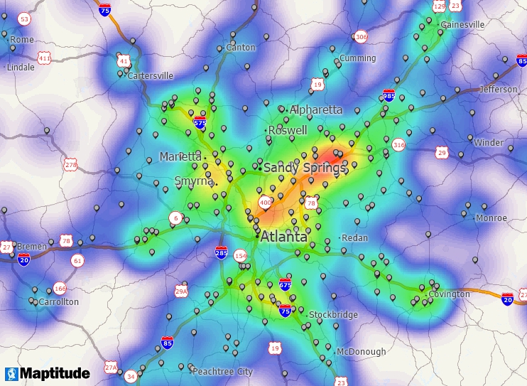
Accurate placement matters when you're planning delivery routes,
drawing territories, or analyzing who lives within a specific radius
of a site. Fresh street data, address ranges, and points of interest
should be included so your results match reality.
2. The ability to
handle truly large jobs
Unlimited batch geocoding should comfortably
process hundreds of thousands or millions of records in a single
workflow and not force you to break everything into tiny uploads.
Features like job queuing, progress indicators, and the ability to
pause and resume processing make high-volume work practical instead
of painful.
3. Automation and integration options
For recurring
jobs, an API or scripting interface is essential. That might mean
sending new addresses from a CRM to be geocoded on a schedule, or
wiring geocoding into an ETL pipeline so every new record enters
your systems with coordinates already attached. The best tools
support common formats (CSV, Excel, database exports) and can be
driven via command line, API, or scheduling tools.
4. Strong data
quality and address handling
High-performing geocoders don't just
fail when they see imperfect data. They standardize and clean
addresses, flag likely errors, and return match-quality codes so you
know how trustworthy each result is. Being able to quickly review
and fix unmatched or low-confidence records is key to maintaining
accuracy at scale.
5. Usable for both technical and non-technical
teams
A powerful engine still needs an approachable interface. Look
for intuitive workflows for loading spreadsheets, configuring
geocoding settings, reviewing match results, and exporting outputs.
Clear tooltips, presets, and sensible defaults let occasional users
succeed without needing a GIS background, while power users still
have access to more advanced options.
6. Outputs that are ready for
analysis
The best batch geocoders don't stop at latitude and
longitude. They make it easy to export clean files for BI tools, or
to immediately visualize results as maps, heat maps, or territories.
Support for formats like CSV, Excel, Shapefile, and GeoJSON means
you can drop the results straight into your analytics stack.
Unlimited batch geocoding isn't just a technical upgrade; it's a way to turn raw address data into decisions that save time, reduce costs, and uncover new opportunities.
Faster operations and lower manual effort
Instead of having staff copy and paste addresses into web tools,
unlimited batch geocoding lets you process entire datasets in one
go. That might be nightly updates from your CRM, monthly customer
lists from your billing system, or weekly delivery runs. Less manual
work means fewer errors and more focus on analysis rather than data
preparation.
Better routing and logistics decisions
For logistics
and field operations teams, accurate geocoding is the foundation for
route optimization. When every stop is placed correctly on the
network, you can cut miles driven, reduce fuel usage, and hit more
time windows. Unlimited capacity means you can optimize an entire
national fleet or a whole week of visits at once rather than
piecemeal.
Sharper targeting for sales and marketing
Marketing teams
can geocode customer and prospect lists to understand where demand
is strongest, where campaigns are underperforming, and which
neighborhoods match ideal customer profiles. That translates into
better territory design, smarter direct mail and door-to-door
campaigns, and more efficient ad spend.
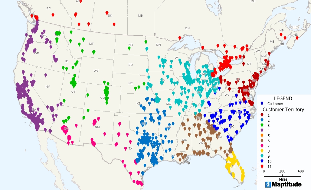
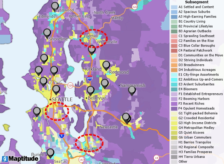
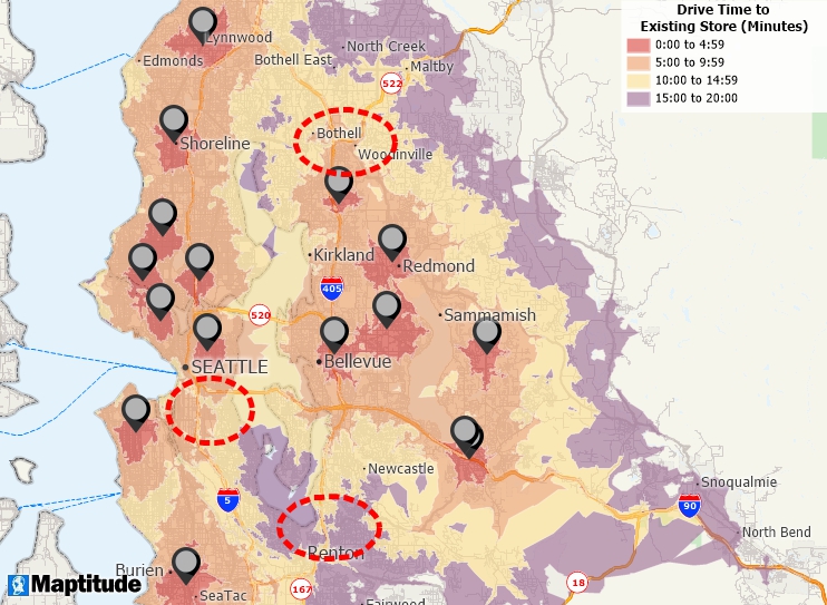
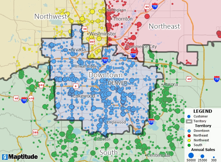
Smarter site selection and
real estate analysis
In real estate and retail, unlimited batch
geocoding supports robust site selection. You can evaluate potential
locations based on drive-time to customers, competitor locations,
traffic counts, or demographic characteristics. By geocoding both
existing stores and candidate sites, you can see coverage gaps and
cannibalization risks instead of guessing.
Clearer insights for
government and public sector
Public agencies often work with very
large address-based datasets such as permits, inspections,
incidents, service requests, or health records. Unlimited batch
geocoding lets them map and analyze these records to identify
hotspots, allocate resources, and communicate clearly with
stakeholders using maps and dashboards rather than raw tables.
A
stronger foundation for AI and advanced analytics
Many advanced
models (catchment analysis, demand forecasting, risk scoring)
perform better when they're location aware. Unlimited batch
geocoding ensures all your records come with coordinates, enabling
you to feed high-quality spatial data into AI and machine learning
workflows across the organization.
The world of geocoding isn't always sunshine and roses. Lurking beneath the surface are complex challenges and potential pitfalls.
The Privacy Predicament: You're handling addresses, frequently classified as Personally Identifiable Information (PII). How much data is being collected, and what measures are in place to protect individual privacy? Can individuals be re-identified from the geocoded data? Who ultimately owns the resulting geocoded data, and what are the legal implications, particularly in light of regulations like HIPAA and restrictive API licenses?
The Accuracy Headache: "Garbage in, garbage out!" is an inescapable truth. Incomplete addresses, outdated maps, the absence of street numbers in rural areas, and ambiguous addresses that match multiple locations are just some of the hurdles in the relentless pursuit of pinpoint accuracy.
"Unlimited" Doesn't Mean Limitless! Be wary of marketing hyperbole. Even "unlimited" services are subject to underlying API rate limits and infrastructure constraints. Employing intelligent strategies like batching and queuing is essential to avoid being blocked or timing out.
The Cost Conundrum: While flat-rate options exist, processing vast quantities of addresses can still represent a substantial investment. Balancing speed, accuracy, and budgetary constraints requires careful consideration.
Data Wrangling Woes: Before you even begin geocoding, you often face the arduous task of cleaning, standardizing, and integrating disparate datasets – a hidden but essential step that can consume significant time and resources.
The future of geocoding is bright, driven by technological advancements and an ever-growing demand for location-based insights.
Smarter, Faster, More Precise Geocoding: Prepare for even greater "rooftop-level" accuracy, as geocoding evolves to incorporate actual building footprints. AI and machine learning will play an increasingly crucial role, enabling systems to understand context with unprecedented sophistication.
Real-time Insights from Everything: The proliferation of IoT devices and the rollout of 5G networks will unleash a torrent of real-time location data. This will lead to innovations like real-time traffic prediction, optimized delivery logistics, and dynamic urban planning.
Hello, 3D Worlds and Digital Twins: Imagine hyper-realistic 3D models of entire cities, enabling advanced simulations and sophisticated planning capabilities.
Cloud is King: Geocoding and GIS platforms will increasingly reside in the cloud, providing unparalleled scalability, flexibility, and collaboration opportunities for managing massive datasets.
Every Industry, Everywhere: Location intelligence will become indispensable across a wider spectrum of industries, powering everything from targeted marketing campaigns to fraud detection and enhanced customer experiences.
Unlimited batch geocoding stands as a powerful and rapidly evolving tool, a far cry from its humble beginnings. The software solutions available today offer remarkable capabilities, but it is critical to grasp the nuances of privacy, accuracy, and the true meaning of "unlimited" claims.
Ultimately, selecting the right tool depends on your unique requirements, data volume, and budgetary considerations. However, one thing remains clear: mastering location data is essential for navigating the future of business.
Ready to unlock the power of your data? Explore these top solutions and begin mapping your path to smarter decisions today!
Among the many tools that claim “unlimited” batch geocoding, Maptitude stands out by offering truly unrestricted processing without extra per-record fees, credit systems, or hidden quotas. You get a complete mapping and analytics environment that includes a powerful geocoder rather than just a bare API.
Truly unlimited, with a straightforward pricing model
With Maptitude, you’re not constantly watching usage dashboards
or worrying about overrunning your monthly credits. You can geocode
as many records as your hardware can handle under a clear license,
which is especially valuable for organizations that process large or
frequently changing datasets.
High-quality, included data out of the box
Maptitude ships with detailed street data and rich geographic
layers, so you can geocode immediately without sourcing and
maintaining separate base maps. Because the software understands
addresses, streets, postal codes, and boundaries, it can return
precise locations and attach useful geographic attributes to each
record.
Precision plus analytical depth
Maptitude
doesn’t stop at putting points on a map. Once your addresses are
geocoded, you can:
This analytical depth means you get insight, not just coordinates.
Offline capability and data privacy
Because
Maptitude runs on your desktop or in your environment, you can
geocode sensitive address data locally instead of sending it to an
external web service. That’s a major advantage when working with
customer, patient, or citizen information subject to privacy or
regulatory requirements.
Cloud and Online
For cloud-based workflows,
Maptitude
Online offers simple drag-and-drop geocoding through a browser,
making it easy for non-technical staff to upload spreadsheets and
get instant mapped results. Together, these options give you a
flexible hybrid approach: automated geocoding when you need scale
and control, and browser-based tools when you need fast, accessible
mapping for everyday tasks.
Geocoding Excel data in Maptitude Online is as simple as dragging and dropping
Flexible workflows for every team
Non-technical users can drag-and-drop spreadsheets, run geocoding
with guided dialogs, and immediately see results on a map. Technical
teams can automate repeatable workflows, integrate with other
systems, and script large jobs, which is ideal for ongoing,
high-volume use.
GISDK API
For teams that need automated,
repeatable, and fully controllable geocoding workflows, the
Maptitude GISDK scripting API provides a direct path to high-volume
processing without external dependencies. You can script entire
geocoding pipelines, trigger batch jobs from other systems,
standardize address inputs, and export enriched results in formats
ready for analytics or downstream applications. This level of
automation is ideal for organizations that routinely process large
or frequently updated datasets.
See unlimited batch geocoding in action
If
you’re ready to move beyond limited web tools and per-lookup fees,
Maptitude gives you the freedom to geocode at scale and the tools to
put that data to work.
Use the Free Trial and Request a Demo buttons on this page to explore how Maptitude can handle your unlimited batch geocoding and mapping workflows end to end.
Learn more about Maptitude to see how you and your team can benefit from mapping software!
Schedule a Free Personalized Demo
Home | Products | Contact | Secure Store
