Maptitude uses GIS data to help manage forest assets, forest resources, and to measure environmental impacts such as deforestation. Maptitude can use spatial data in a variety of formats including those from Esri and from sources such as the USDA Forest Service and Forestry and Land Scotland. Maintaining the health and distribution of forest inventory is a primary concern of many organizations, and Maptitude can assist in these efforts through effective mapping.
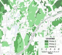
Maptitude GIS for forestry map of prime forests
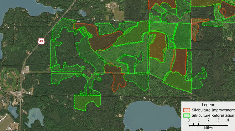
Maptitude foresters mapping software map of silviculture improvement and reforestation
 |
“For special projects and reports, Maptitude provides better analysis and illustration of information. Using tabulated data, this program creates maps, charts, and graphs. For example, the extreme damage caused by Hurricane Ivan in September 2004 required immediate emergency response from the AFC.”
|
 |
“Our agency of 250 employees have 65+ offices scattered throughout Alabama. We have certainly gotten our money’s worth out of the software and have produced thousands of maps using Maptitude. It is an easy program to learn and draw with. It has been used over the years to help forest landowners manage their forestland.”
|
 |
“I use Maptitude from Caliper in Mass. and a Trimble GEOXM with ArcPad. Load the GIS right onto the GPS unit with an aerial photo and off you go. Used it for 6 years and have traversed several hundred acres a year for thinning.... Maptitude is 1/3 the cost of ArcMap and does more out of the box.”
|
|
|
“The South Carolina Forestry Commission has been looking for a low cost desktop mapping application for use by its field foresters in preparing forest stewardship and other forest management plans. After several years of looking at what was available, the Commission selected a product from Caliper Corporation called Maptitude....Consulting foresters and landowners can easily afford to explore the benefits of GIS in their daily operations. It has powerful tools that make map creation easy.”
|
Maptitude supports these forestry services:
Read Maptitude case studies to see just how useful Maptitude is for forestry mapping!
See how the South Carolina Forestry Commission uses Maptitude to help field foresters in preparing forest stewardship and other forest management plans. Their major use for Maptitude is by their field foresters, enabling them to improve the quality of forest management maps that are used in plans developed under landowner assistance programs. In addition to ease-of-use and affordability, other attractive elements of the software included support for heads-up digitizing that can then be utilized to create forest management maps; accurate measurement tools for acreage and distances; report creation features that include legends, north arrows, timber type summary tables, charts, etc., that help produce a final high-quality map.
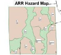
See how the Alabama Forestry Commission (AFC) uses Maptitude to produce specialized and professional maps for the TREASURE Forest Plan for landowners. The maps depict Forest Land Cover, the Southern Pine Beetle (SPB) Hazard Rating and Infestation, and the Annosus Root Rot Hazard Rating. A General Location map is also needed with this plan. Global Positioning System (GPS) coordinate data from AFC flights are input into Maptitude to be used by the Mapping Forester to create topographical and aerial photographic maps showing individual and county-wide SPB spots. These maps are shared with the county and the impacted landowners.
Maptitude is also used to create thousands of Landowner Assistance Stand Maps. One of the objectives of the Alabama Forestry Commission's three-fold mission is to provide forest management recommendations to landowners, which happens daily. Forestry professionals also provide a Stand Map, and for forest management stewardship plans for a landowner’s entire property a Plan Map is created. All of this is vitally important to ensuring that Alabama's forests, mostly owned by private individuals, are environmentally healthy and provide multiple benefits, including a steady wood supply for the forest industry.
Maptitude is also used for emergency response. The extreme damage caused by Hurricane Ivan in 2004 required every AFC division to participate in relief efforts. The Management Division completed a survey and assessment of all timber product classes damaged by the storm and summarized the conclusions in the Hurricane Ivan Timber Damage Report. Both the graphs for the analysis and the maps locating damaged areas were created using Maptitude. Each area was digitized into the GIS program and saved as a map. County maps illustrating these impacted areas were printed and used in local landowner meetings as well as in the final timber damage report.
 Check out our G2 Reviews
Home | Products | Contact | Secure Store