

Author:
Stewart Berry
Images: Dan Martin
10 October 2025
Maptitude is the most cost-effective GIS software available. It is now affordable for any level of government to produce and update the maps they need.

|
“If you need to create data sets, Maptitude is the way to go; with the book and tutorials a normal person can do wonders with the program. Also, training the non-GIS casual user is easy.” Carl L. Chance |
Maptitude maps are a great way to share planning information with the public. The reports are simple to create, and they are in an easy-to-understand format. GIS software for government is a valuable tool for:
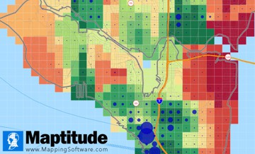
Maptitude GIS solutions for local government - Use the included data or import data from numerous sources

|
“As far as ease of use goes Maptitude takes the prize, Maptitude is definitely easier to use right out-of-the-box and the learning curve for advanced functions is shorter than with MapInfo. As for presentations, Maptitude takes the prize again over MapInfo. The folks at Caliper took great pains and effort to make a GIS software application that is as user friendly as possible. They took the cartographic prep-work out of the equation, so that the user can spend less time trying to make the map look pretty and can focus on doing the actual analysis and presentation.” Victor Keenan |
Included with Maptitude are the Census Place and County Subdivision outlines. These come from the U.S. Census Bureau for mapping cities, towns, and municipalities. You can also use Maptitude to access and display data from numerous other sources and formats.
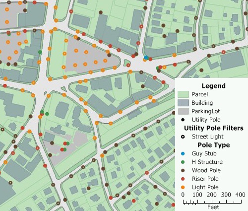
Maptitude map software for municipal government: Use Maptitude to inventory and manage infrastructure such as sewers, catchbasins, and utility poles
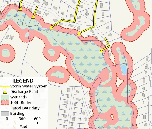
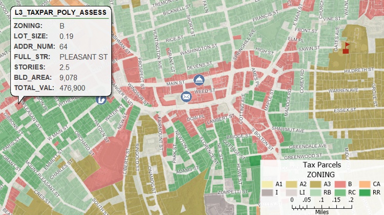
GIS for local government: Maptitude is an affordable solution for all local government needs such managing natural resources and critical infrastructure
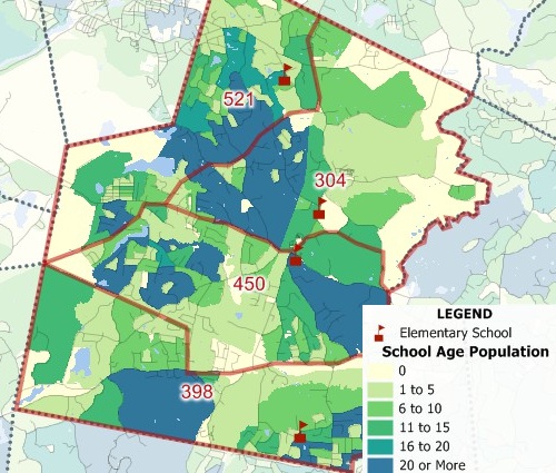
Map software for local government: Use the Maptitude Territory Manager to plan school districts
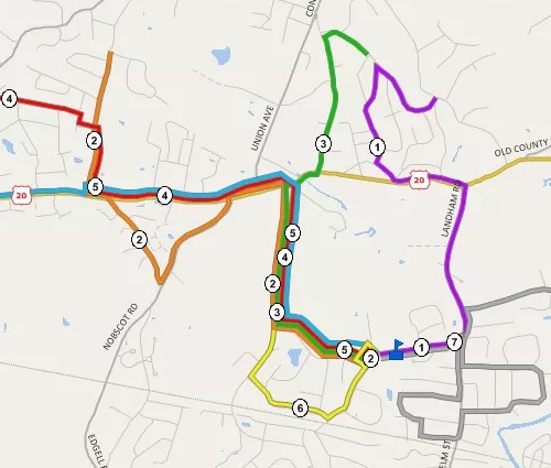
GIS solutions for local government: Use the Maptitude routing tools to plan municipal bus routes or school bus routes

|
“Maptitude is a great alternative to [other mapping software]. Using Maptitude, I can easily create 3-D maps, heat/hot spot mapping, Areas of Influence (Thiessen Polygons), drive-time rings, flow maps (desire lines and spider maps), territory mapping, and spatial overlays (tagging features from one layer to another), trade area/site selection and much more.” Brett Lucas |
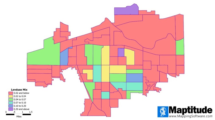
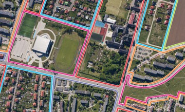
Maptitude mapping software for municipal government - Map comparing land use mix of Neighborhood Commercial vs. Single-Family Residential
Create your own maps! Try the full-featured version of Maptitude with a 1-month risk-free trial. No credit card is required

 How to Measure "Land Use Mix"
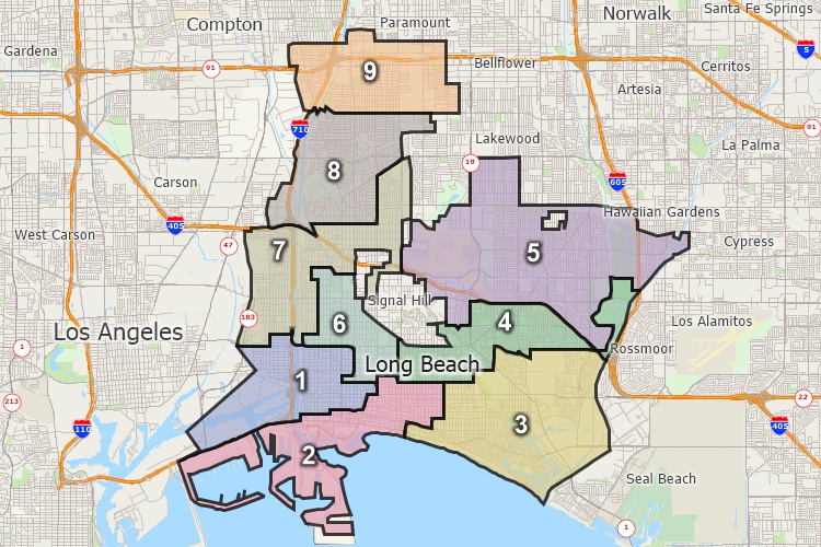
Many municipalities need to redraw municipal ward and district boundaries. This is done after the decennial Federal Census. Municipal redistricting is influenced by:
The City/County Edition of Maptitude for Redistricting is the best software to get the local government redistricting done. This version comes with the data for your city or county, all ready to use.
Choosing the right GIS solution for local government can be challenging. Maptitude empowers agencies to improve public services, enhance decision-making, and manage resources effectively. Here’s what our satisfied users have to say:
 |
“Our agency of 250 employees have 65+ offices scattered throughout Alabama. We have certainly gotten our money’s worth out of the software and have produced thousands of maps using Maptitude. It is an easy program to learn and draw with. It has been used over the years to help forest landowners manage their forestland.”
|
 |
“Maptitude has extensive functionality...and a significantly flatter learning curve than other GIS software.... You get a fully functional GIS and extensive data for 1/3 the price of other GIS products.”
|
Geographic Information Systems (GIS) are powerful tools that are used in many different fields, including local government. In local government, GIS is often used for a variety of purposes, including mapping and spatial analysis. This allows local governments to make informed decisions about the use of resources and the allocation of resources in their communities. For example, GIS can be used to create maps that show the location of schools, hospitals, and other important facilities, as well as to identify areas that may be in need of additional resources or support. Additionally, GIS can be used to help local governments plan for and respond to emergencies, such as natural disasters or public health crises. Overall, GIS is a valuable tool that helps local governments to better understand and serve their communities.
1. Governments can use GIS information to analyze and map demographic data, such as population density, income levels, and age distribution. This can help governments to identify trends and patterns in their communities, and to plan for the provision of services and infrastructure accordingly.
2. Governments can use GIS information to manage land use and zoning. By mapping land use patterns, governments can identify areas that may be suitable for development, and can also track changes in land use over time. This information can be used to support planning and zoning decisions, and to ensure that land is used in a sustainable and responsible manner.
3. Governments can use GIS information to track and respond to environmental hazards, such as air and water pollution, natural disasters, and climate change. By analyzing spatial data, governments can identify areas that are at risk, and can develop strategies to mitigate these risks and protect the health and safety of their communities.
These are just a few examples of the ways that governments can use GIS information. Other potential uses include transportation planning, public safety and emergency management, and economic development.
GIS helps government agencies collect, analyze, and manage geographic data so they can make more informed decisions. It can be used to help assess changes in population, environment, infrastructure, and other factors. It can also help identify potential risks and plan future investments. GIS allows government agencies to quickly identify and respond to changes in their area of responsibility, improving the efficiency and effectiveness of their operations.
A local government GIS (Geographic Information System) is a computer system used by local governments to store, manage, analyze, and display geographic data. This data can include land use, population, infrastructure, and environmental information. GIS can help a local government to make better decisions, plan projects, and improve services.
GIS is an invaluable tool for municipalities, as it enables them to better manage their resources, plan for growth and development, and make better decisions. GIS can be used to create accurate maps and geographic models, analyze land use and zoning, monitor traffic and infrastructure, and analyze demographics. GIS can help cities and towns more effectively manage their resources, plan for future development, and monitor natural disaster risks and hazards. GIS can also be used to better analyze the needs of citizens, providing the data and insight needed to make informed decisions.
Follow the steps in this video to learn how to create a mask.
Follow the steps in this tutorial to learn how to filter and export your area of interest.
 Check out our G2 Reviews
Maptitude |
There are many benefits when you use Maptitude map software for municipal government:√ Maptitude is the easiest-to-use full featured mapping software and includes powerful tools √ Maptitude has no subscription fees and supports secure off-line data storage
√ Maptitude provides fully customizable maps with unlimited point icons √ Maptitude has unlimited pin-mapping/geocoding √ Maptitude includes free mapping data and demographics covering everything from population statistics to business locations, postal/ZIP Codes, and more! |
Maptitude for Municipal Government: Economic Development WebinarMaptitude for Municipal Government: Public Safety Webinar |

Home | Products | Contact | Secure Store
