By Philip Moya, San Antonio Kidney Disease Center
A few years ago I was asked if I could build a map with dots representing all of our patients. That was simple enough, but not very helpful. When I presented the map, it created more questions than it answered. On top of that, it was not very user friendly for a non technical person to create or present.
The doctors needed to see where patients lived based on different criteria and sometimes on subsets of that criteria. They needed to be able to contrast one set versus another very quickly. And, I needed to not be in the room when they were having these discussions. I needed a simple way for them to be able to use this data.
I tried several of the basic mapping programs like Microsoft MapPoint and StreetAtlas. None of those gave me what I needed and they would be too cumbersome for the presenter. Then I stumbled on Caliper Corporation's Maptitude. This is by no means a simple piece of software, but it is a fully GIS compatible mapping solution and it did have one really cool feature. It had the ability to export to KML file. This meant that I could create really complicated maps based on the data from our Patient Management System and give it to the presenter in a dead simple way to use it. For those that don't know what a KML files are, they are the native format used for Google Earth.
The presenters and the doctors had all played with Google Earth, they were familiar with the interface. Who hasn't skimmed the earth looking for places you have been, places you want to go or even your house. This was a good solution.
I can now deliver the maps via email and there is no need for me to attend the meetings just to run the maps. This has changed how we make decisions on where to place clinics and dialysis centers. It also helps us make decisions on what clinics to grow and increase staffing to. It has become a critical part of the strategic planning retreats.
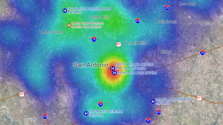
The maps they have me make include pin points, areas of influence, heat mapping, zip code zoning, population density, and more. All of which I can export to a KML file and display it as if it was included in Google Earth.
Caliper Corporation develops state-of-the-art Geographic Information Systems (GIS) and transportation software. Caliper is a privately-held corporation and is a leading developer of mapping, redistricting, transportation, and GIS software. Caliper is also a highly regarded consulting and R&D provider, offering professional services in quantitative management consulting, transportation, and decision support systems development. Caliper software products are supported with extensive technical services in GIS applications and training, database development, and software customization.
 “This is
awesome mapping software. We use it to create heat maps of where our
patients live. This allows us to intelligently decide where to add
services in our area.”
“This is
awesome mapping software. We use it to create heat maps of where our
patients live. This allows us to intelligently decide where to add
services in our area.”
Philip Moya
San Antonio Kidney Disease Center
San Antonio Kidney Disease Center Physicians Group, P.L.L.C. (SAKDC) is the largest nephrology practice in San Antonio, specializing in the diagnosis and treatment of high blood pressure, kidney disease, hemodialysis and peritoneal dialysis, as well as the preparation for and treatment of patients with kidney transplants.
Home | Products | Contact | Secure Store