|
Focus on Maptitude:
Maptitude
2014 Released for the U.S. With the Most
Up-To-Date Data
Maptitude 2014, a major new release of Caliper's popular
mapping software, provides a wealth of the
latest available data for business applications as
well as significantly enhanced analytical and
visualization capabilities.
The U.S. Census boundaries (e.g.,
Tracts, Counties, MCDs, MSAs, States)
and ZIP Codes contain
updated demographics and the latest
Census data including: buying
power/disposable income, health
insurance coverage, FFIEC banking
compliance data, travel time to work,
aggregate/median income by race, and
projections for 2015 and 2020. Maptitude
2014 also ships with the January 2014
ZIP Code release ensuring the use of the
latest nationwide postal data. Maptitude
2014 includes an October 2013 road map,
allowing accurate address locating and
street visualization plus robust data on
which to calculate distances and travel
times, drive-time zones, and drive-time
territories.
The 2014 USA Country Package contains
new and updated data critical to many
industries (more...).
Marketing and sales analysts will
benefit from knowing the buying power of
those ZIP Codes projected to grow over
the next 1-5 years, while banks can
ensure regulatory compliance using the
FFIEC data. Maptitude 2014 allows those
in healthcare to map the dynamics of
health insurance coverage across regions
and between populations. All these
figures can also be compared to income,
population density, age distribution,
race, ethnicity, poverty, and many other
current demographics.
Some of the data, such as Caliper's
proprietary purchasing power estimates,
are among the most accurate available
from any source and significantly more
reliable than U.S. Census data. The
included data alone are worth many
multiples of the software's purchase
price.
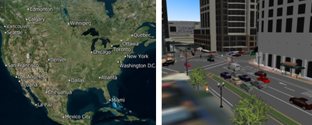
Maptitude's full-featured, but
easy-to-use mapping application has also
been significantly enhanced. Polished
reports can now be created via a single
click, allowing direct sharing of your
geographic analysis. Map backgrounds can
be seamlessly switched to show aerial
photo-imagery or terrain, adding
realistic and relatable elements to your
presentations. Maps can now be
visualized in a stunning and compelling
3-D view and users can add their own 3-D
buildings and scenery. The drive-time
ring engine has been significantly
enhanced and provides the most accurate
analysis available in any mapping
product.
The most exciting features of Maptitude
2014 are showcased here,
and a complete description of the new
features in Maptitude 2014 is available
as a
PDF here. Currently, the 2014
USA Country Package has been
released. Updated Packages for other
countries will follow soon!
Maptitude includes everything
required
for geographic market analysis, is considered
the easiest-to-use professional mapping
product, and costs only US$695.
Upgrade pricing is available (more...)
and for ordering information please
visit the Mapping
Software Store, e-mail
Maptitude Sales, or call U.S. Sales
at +1 617-527-4700.
Featured Maptitude Maps:
Percentage of People Without
Health Insurance and Type of Coverage (by USA State)
The Maptitude
2014 USA Country Package includes a
wealth of new data such as buying
power/disposable income, health
insurance coverage, FFIEC banking
compliance data, travel time to work,
aggregate/median income by race, and
projections for 2015 and 2020 (more...).
Upgrade to Maptitude 2014 now to access
the latest demographics.
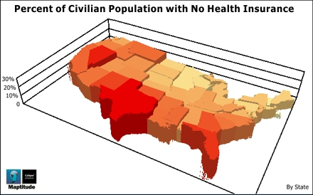
The dynamics of health insurance coverage vary
substantially across regions. Maptitude 2014 allows
you to map these differences in public vs. private
insurance, those without insurance, and coverage for
those who are employed or unemployed. These figures
can also be compared to population density, age
distribution, disease prevalence, race, ethnicity,
poverty and the ability to access care.
Maptitude is widely used to conduct research in the
health care sector.
Maps help to visualize health care information
and enhance the understanding of the health care
landscape. Maptitude mapping software enables users
to find data about hospitals, health insurance, and
at risk populations.
More Featured Maps...
If you would like to see your maps showcased here,
or are interested in
custom map making services and
software please
contact
Caliper.
Using Outdated
Data & Technology?
Upgrade to Maptitude 2014!
Users of Maptitude 2013 and Maptitude
2012 can still get our US$395
reduced upgrade pricing. This deal
saves you US$300! Upgrade now to avoid
being caught out by using last year's
features and data.
Also, each US order will include a free US
ZIP Code update: a US$250 value! The
combination of the offer and free data saves
you US$550!
For pricing and ordering information
please visit the
Mapping Software Store, e-mail
Maptitude Sales, or call U.S. Sales
at +1 617-527-4700.
Limited Offer: Valid for Maptitude 2012
or later.
Restrictions Apply.
You need the newest maps, the latest
demographics, and the fastest, most
intuitive Maptitude!
  |
| |
|
Maptitude 2014 Training (New!):
Limited Availability
 New
topics cover Maptitude 2014!
Advance
registration for the instructor-led training courses is required.
Upcoming classes: New
topics cover Maptitude 2014!
Advance
registration for the instructor-led training courses is required.
Upcoming classes:
•
March 3-5: Boston MA
Space is limited, so
register online as soon as possible.
If you have any questions, please call Maptitude
Training (USA) at +1 617-527-4700, or send
an e-mail to
sales@caliper.com.
|
Maptitude International News:
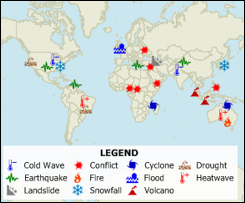
United Nations
Humanitarian Point Styles
There is no limit to the number of point styles that can be applied
in Maptitude. You can use any of your own images, plus the software
includes hundreds of icons that can differentiate
customers, locations, and competitors.
Maptitude 2014 includes the
United Nations Office for the
Coordination of Humanitarian
affairs (OCHA) icons to help
relief workers present emergency
and crisis-related information
quickly and simply. The set of
symbols covers complex
humanitarian issues such as
access to people in need and
protection of civilians, plus
those for natural disasters and
relief supplies.
|
|
Did You Know?
One-Click
Help
 You
can easily familiarize yourself
with the new features in
Maptitude 2014 via the wealth of
free learning materials
provided for the software. You
can easily familiarize yourself
with the new features in
Maptitude 2014 via the wealth of
free learning materials
provided for the software.
Also, when using a new tool or
hovering over a menu item or
button, you can click the F1 key
on your keyboard. This provides
you with context-sensitive help.
The electronic help
automatically flips open to the
exact section that you need, and
provide step-by-step guides and
tutorials on using Maptitude, as
well as links to related videos.
|
Maptitude
News and Press:
• Maptitude
Has the Best Maps
•
Draw Congress:
Redistricting and
Gerrymandering
•
Oakland Local: City
Council will look at two
maps in its
redistricting debate
tonight
•
More Maptitude News...
Maptitude
Solutions:
Banking GIS
Business Mapping
Census Data Mapping
Community Development
Election Management
Enterprise GIS
Franchise Mapping
GIS Software
GPS Mapping
Insurance Mapping
Law Enforcement GIS
Location Intelligence
Marketing & Sales Mapping Software
Public Health Mapping
Real Estate Mapping
Redistricting
Route Planning & Deliveries
Satellite & Aerial Imagery
Street Mapping
Territory Mapping
Web Mapping
World Mapping
|
|
Tech Tip:
Creating
Drive-Time Zones Demographic Reports
Travel time is the most realistic way of
describing market areas and access to
services. A franchise may want to define
their territories based on the time
required to reach their customers.
Emergency services may want to map their
response time coverage for an area. The
drive-time tool ("Network Bands") in
Maptitude 2014 supports these types of
analysis based on the creation of
realistic catchment areas, and with a
single click can create a professional
demographic report (see
video here).
 The
creation of drive-time zones (also known
as drive-time "rings") allows you to
determine which areas can be accessed
within a particular drive-time or
drive-distance. The
creation of drive-time zones (also known
as drive-time "rings") allows you to
determine which areas can be accessed
within a particular drive-time or
drive-distance.
Using this tool you can calculate the
market characteristics and demographics
around your locations, and estimate the
duration of services such as repair or
delivery calls. You will also be able to
better describe the convenience of your
locations in terms of time rather than
as a crude straight line measurement.
For a facility you can better identify
potential customers within five minutes
rather than within two miles. For
example, takeout delivery businesses can
quickly determine those destinations
within their drive-time trade/service
areas.
Drive-time analysis uses streets and
approximate driving times based on road
characteristics such as speed limits.
The starting points/origins are
typically businesses, retailers,
hospitals, or any other organization
exploring the provision of services and
proximity to competitors and affiliates.
The output of drive-time rings differs
significantly from the more simplistic
rings ("Buffers") that define areas
based on straight-line ("as the crow
flies") distances.
In Maptitude 2014, Network Bands are
significantly more robust. You can now
create multi-ring analyses around
multiple points nationwide, while being
able to quickly view an exportable
demographic report for the areas
reached.
The
following steps illustrate how to create a drive-time
zones demographic report for your
locations:
-
Choose File-New and use
Create-a-Map Wizard to create a general purpose map
for your area of interest.
-
Choose Tools-Routing-Network Bands
or click
 to display the Network Bands
toolbox. to display the Network Bands
toolbox.
-
Click
 in the Network Bands toolbox to
activate the Click Origin Points tool. in the Network Bands toolbox to
activate the Click Origin Points tool.
-
Click on on the map. Maptitude places symbols
at each of the clicked points.
-
In the Network Bands toolbox choose to create, for example, 3 bands of 5
minutes.
-
Click
 in the Network Bands toolbox.
Maptitude creates the bands and adds them to the map
along with a color theme to illustrate the driving
distances. Any portion of the map that is not
covered by a band is greater than the travel-time
you chose from the clicked locations. in the Network Bands toolbox.
Maptitude creates the bands and adds them to the map
along with a color theme to illustrate the driving
distances. Any portion of the map that is not
covered by a band is greater than the travel-time
you chose from the clicked locations.
-
If you want to compute the demographics for the
network bands, click
 in the Network Bands
Toolbox. Maptitude calculates the overlay and
displays the results in a dataview. in the Network Bands
Toolbox. Maptitude calculates the overlay and
displays the results in a dataview.
-
If you want to create a report with the map and
demographics, click
 in the Network Bands Toolbox.
Maptitude generates the report and displays it in a
new window. You can customize a report with your
company name by choosing
Edit-Preferences and making changes on
the Reporting tab. in the Network Bands Toolbox.
Maptitude generates the report and displays it in a
new window. You can customize a report with your
company name by choosing
Edit-Preferences and making changes on
the Reporting tab.
Reports can be printed, saved, exported, and
emailed.
To export your results you can
choose File-Export
Document from the Report
window menu to export your report for use outside
of Maptitude.
|
