| Upgrade to Maptitude 2018 for US$395: Last Chance! |
|
|
|
| New Release: 4 Ways Maptitude 2018 Saves You Time & Money |
| Business analysts need their latest data in their maps. Franchisors and retailers need to ensure that their store network is optimized to best serve their customer base. Hospitals and banks need the most up-to-date demographic information. Maptitude 2018 makes it easier than ever to meet these requirements. Here are 4 key areas where Maptitude 2018 will prove critical for your organization: |
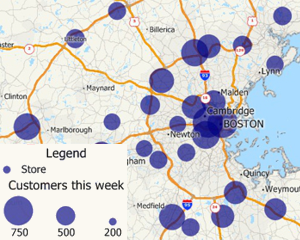
1. Data Linking & Updating
Maptitude can link to external data such as an Excel spreadsheet or SQL Server database and can update your map layers based on changes in your tables without having to reimport your data from scratch.
Example: You can link to data that contains weekly sales figures for your stores so that you can keep the map updated with the latest sales information.
» Learn how in this video tutorial
|
|
|
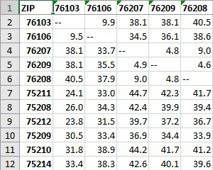
2. Logistics
The Distance and Travel Time Tables Tool creates an Excel table that lists the cost of travel between any number of origins and destinations. You can quickly identify the closest and backup locations ranked by straight line distance, travel distance, or travel time.
Example: You can calculate the distance and time your customers must travel to access any of your locations, or calculate the distance among ZIP Codes to estimate shipping costs.
» Learn how in this video tutorial
|
|
|
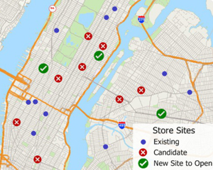
3. Site Selection
The Facility Location Wizard identifies good locations for warehouses, hospitals, retail stores, manufacturing plants, and other types of facilities. The goal in locating such facilities is to provide a high level of service.
Example: You can determine the number and locations of franchises/stores required to provide the best access to your customers.
» Learn how in this video tutorial
|
|
|
4. Software and Data
Many MapPoint users have switched to Maptitude, but there is still widespread use of MapPoint. Using MapPoint is detrimental to your business operations and destroys the credibility of your reports because the data you are using was outdated even at the time of release. Maptitude 2018 ships with the most up-to-date geographic and demographic information available. Maptitude also includes all the key features and tools of MapPoint (more...).
|
|
|
| There are many more improvements in Maptitude 2018. Please contact the Maptitude Sales Team with any questions. View our new Maptitude 2018 videos here. |
 |
What do you like best?
Simple interface; good availability of data (and often it's free); easy to use; simple to administer. I've never had to call support!
What benefits have you realized?
General mapping; number and location of facilities compared to others; We've been able to improve our reports to our customers with excellent depictions of the results.
Chris Wieman
Director, Technical Services, Bates White LLC |
 |
What do you like best?
Maptitude is a very versatile GIS system which is able to produce a wide variety of maps economically.
What business problems are you solving with the product?
Maptitude is critical for providing information in commercial real estate location selection.
Louis Scudere
Principal, Riverbend Retail Consulting LLC |
|
Featured Map:
Happiest States in the USA
|

|
This month's featured map showcases new lifestyle data for Maptitude 2018. Data on happiness, health, and habits are included for State, County, Census Tract, and ZIP Code layers. Please contact Caliper Sales if you need help using these data.
» More about this map and other featured maps
|
Tech Tip:
How do I import MapPoint waypoints and use them with the Routing Manager? |
Maptitude 2018 can import waypoints from MapPoint and Streets & Trips. A point layer is created that can be used with the Routing Manager to create directions.
Maptitude keeps all of the MapPoint stop attributes such as name, stop number/sequence, overnights, whether the stop is a start/intermediate/end type stop, stop times, whether a quickest or shortest route, and preferred arrival and departure times. The Maptitude Routing Manager can use all of these attributes to recreate your route.
» Learn How Here
|
|
|
Tricks & Tips:
Adding a heat map (color theme or shaded boundaries) to an open map in Maptitude 2018 |
Maptitude 2018 makes it easy to show your data attached to boundaries and to add the data to an existing map.
Choose Map > Add Data to a Map and follow the prompts.
When prompted to choose the Type of Map, highlight any of the Show boundaries with your data attached options. The Add your data to existing map checkbox is chosen by default.
Any theme that you choose to create will be added to the working map by Create-a-Map Wizard unless you already have a theme on the boundary type you highlighted above.
|
|
|
Learning Maptitude:
Webinars and Training Dates |
|
|
International Mapping:

|
|