|
|
Maptitude
Data Product:
2012 Tract
(USA) Demographics!
|
|
Maptitude includes the FFIEC's 2012 Census Tract
Demographic Information. These data help financial
institutions comply with consumer protection
requirements but also
provide valuable data for use in all industries.

These
demographics add detailed cross-tabulated data to
the
US Census Tracts. The Maptitude 2013 Census Tract
layer contains:
| • |
New
FFIEC demographics for
2012 covering
age by language spoken,
income by race, gender
by age by education,
poverty status broken
down by gender/marital
status/children/age,
housing stock by race,
housing rent & values,
and
distressed/underserved
areas.
|
| • |
New demographic projections
for 2015 and 2020 covering
population, age, race, gender, and
ethnicity.
|
| • |
A nationwide area database
with Tracts for all 50 states, the District of Columbia, Puerto
Rico, and the territories.
|
| • |
Demographic data at no additional cost, including more than 400 fields
from the 2011 ACS and 2010 U.S. Census for population, age, marital
status, education, occupation, industry, race, income, housing
values/ characteristics/ loans, rentals vs. owners, gender,
Hispanic origin, mode of travel, and households by type.
|
Price:
Maptitude costs US$695 per user/license, with a free download.
Order online at the Caliper Store Now or call Maptitude
Sales (USA) at +1 617-527-4700.

|
|
|
Maptitude Classroom Training:
Limited Availability!
Maptitude 2013 Training:
 Boston, MA /
 London, England
 |
|
 The
next scheduled instructor-led training courses will be
October 21-23 in Boston MA (USA) and
December 16-17 in London, England (UK). Advance
registration is required. The
next scheduled instructor-led training courses will be
October 21-23 in Boston MA (USA) and
December 16-17 in London, England (UK). Advance
registration is required.
The new and updated curriculum reflects
the features in Maptitude 2013.
Space is limited, so
register online as soon as possible.
If you have any questions, please call Maptitude
Training (USA) at +1 617-527-4700, or send
an e-mail to
sales@caliper.com.
|
|
|
|
Caliper also offers several training options:
•
Instructor-led classroom training
•
Private training
•
Web-based training
•
Free Learning Resources
•
Free Mapping Software Webinars
|
|
|
|
Free Mapping Resources: |
|
This month's free resource
is free training webinars hosted by an
expert Maptitude trainer. The webinars
cover the most commonly used
tools in the software and include Q&A
sessions.
|
|
| |
|
|
| |
International News:
Updated Country Packages:
Portugal |
|
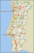 Caliper is excited to announce
a significant update to the geographic information
included in the
Country Package for Portugal! Caliper is excited to announce
a significant update to the geographic information
included in the
Country Package for Portugal!
Maptitude ships with one country of your choice (see
complete list), and additional Packages can be purchased
separately for US$595.
You can seamlessly switch
among the countries you have
purchased, which refreshes the
Maptitude interface with country-specific tools such as those for
creating maps, finding locations, pin mapping (geocoding), and routing.
If you have
any questions, please call Maptitude Sales (USA) at +1
617-527-4700, or send an e-mail to
sales@caliper.com.
|
|
| |
Did You Know?
Heat Maps Directly From Tables |
|
 The
Map-Color Theme
command allows you to
create a color (or "heat")
theme. You create color themes
by picking the data field you
want to see mapped or create a
formula field. MapWizard will
take care of the rest. The
Map-Color Theme
command allows you to
create a color (or "heat")
theme. You create color themes
by picking the data field you
want to see mapped or create a
formula field. MapWizard will
take care of the rest.
You can create a color theme
directly from a table window by
highlighting a cell in the data field you
want to map and clicking
 .
Maptitude creates a new map that uses a
color theme to illustrate the
values of the chosen field.
Note: To create a theme from
your data, it must be connected
to a map layer. To join data to
a map see "Joining Your Data to
a Map" in the Help. .
Maptitude creates a new map that uses a
color theme to illustrate the
values of the chosen field.
Note: To create a theme from
your data, it must be connected
to a map layer. To join data to
a map see "Joining Your Data to
a Map" in the Help.
|
|
| |
You need the newest maps, the latest demographics,
and the fastest, most
intuitive Maptitude!
  |
|
|
Maptitude Spotlight:
Using
Outdated Data & Technology? Upgrade to
Maptitude 2013!
|
|
 Users of Maptitude 2012 and Maptitude
6.0 can still get our US$395
reduced upgrade pricing. This
deal
saves you US$300! Upgrade now to avoid
being caught out by using last year's
features and data. Users of Maptitude 2012 and Maptitude
6.0 can still get our US$395
reduced upgrade pricing. This
deal
saves you US$300! Upgrade now to avoid
being caught out by using last year's
features and data.
Also, each US order will include a free US
ZIP Code update: a US$250 value! The
combination of the offer and free data saves
you US$550!
Maptitude 2013 is a major new release.
Upgrade to get the most detailed
and accurate
data and demographics ever included.
For pricing and ordering information
please visit the
Mapping Software Store, e-mail
Maptitude Sales, or call U.S. Sales
at +1 617-527-4700.
Limited Offer: Valid for Maptitude 6.0
or later.
Restrictions Apply.
|
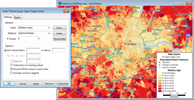
Tech Tip:
Creating a
Heat/Color Map Theme on Areas |
|
Maptitude can use information about locations in a
map to create a presentation that illustrates the
patterns in the data. This is called a
thematic map. Thematic maps use distinctive
colors, symbols, and styles to show information such
as population, sales, or income. The different
styles highlight the similarities and differences
among locations. When data are portrayed in a
thematic map, the information becomes easier to see,
understand, and interpret.
For example, the USA Country Package includes
nationwide
Tract boundaries with hundreds of demographic
variables so that you can create insightful and
informative maps at a neighborhood level anywhere in
the United States. With a few clicks of the mouse,
you can create thematic maps that will allow you to
quickly analyze data for your area of interest. In
addition, Maptitude includes a number of predesigned
Tract level maps in a
Map Library.
The
following steps illustrate how to create color themes
that group the locations in a map layer into ranges,
based on the value of a data field. Each range
contains all of the locations with similar values.
When the map is drawn, the ranges are displayed
using different colors:
-
Choose File-New,
choose Map
from the New File dialog box, and
create a General Purpose map of your study area.
-
Choose a working map layer such as US Census Tracts.
You can do this by right-clicking on the layer in
the Display Manager and selecting Make
Working Layer. If this choice is disabled
first choose Show Layer.
-
Choose Map-Color Theme or
click
on the Standard toolbar to display the
Color Theme dialog box.
-
Choose a field from the drop-down list, or choose
Formula at the end of the list to create a formula
field. MapWizard fills in all the other settings in
the dialog box.
-
Click OK.
Maptitude draws the map with the color theme and
displays a legend.
|
Featured Maptitude Maps:
J. C. Penney Store Site
Location Analysis |
|
This month we showcase a map created by Lucas Mapping
Solutions. "Below is a map that shows a 10, 20 and 30
mile buffer/radius around each J.C. Penney Store in
Iowa. Also shown on this map is the underlying
population per square mile. This type of map can
help a business determine if there is a population
base that is under-served, and where to consider
sites for expansion."

(Maps: Lucas Mapping Solutions, 2012)
More Featured Maps...
If you would like to see your maps showcased here, please
contact
Caliper.
|
|