Maptitude for Redistricting is the proven alternative to AutoBound™ by Citygate GIS. It is the most-widely used redistricting software and was chosen by a supermajority of state legislatures in the 2000, 2010, and 2020 cycles. It comes with built-in Census and American Community Survey data, lets the public draw and submit complete plans online, and analyzes your maps with AI Ensembles, all in software that is fast and easy to learn.
Maptitude for Redistricting is the professional tool for political redistricting. It is used by a supermajority of the state legislatures, political parties, and public interest groups. Designed with the help of redistricting professionals, state legislatures, and political parties, Maptitude for Redistricting has the features redistricters want and is easy to learn and use. There are many benefits when you use Maptitude for Redistricting as a replacement for AutoBound.
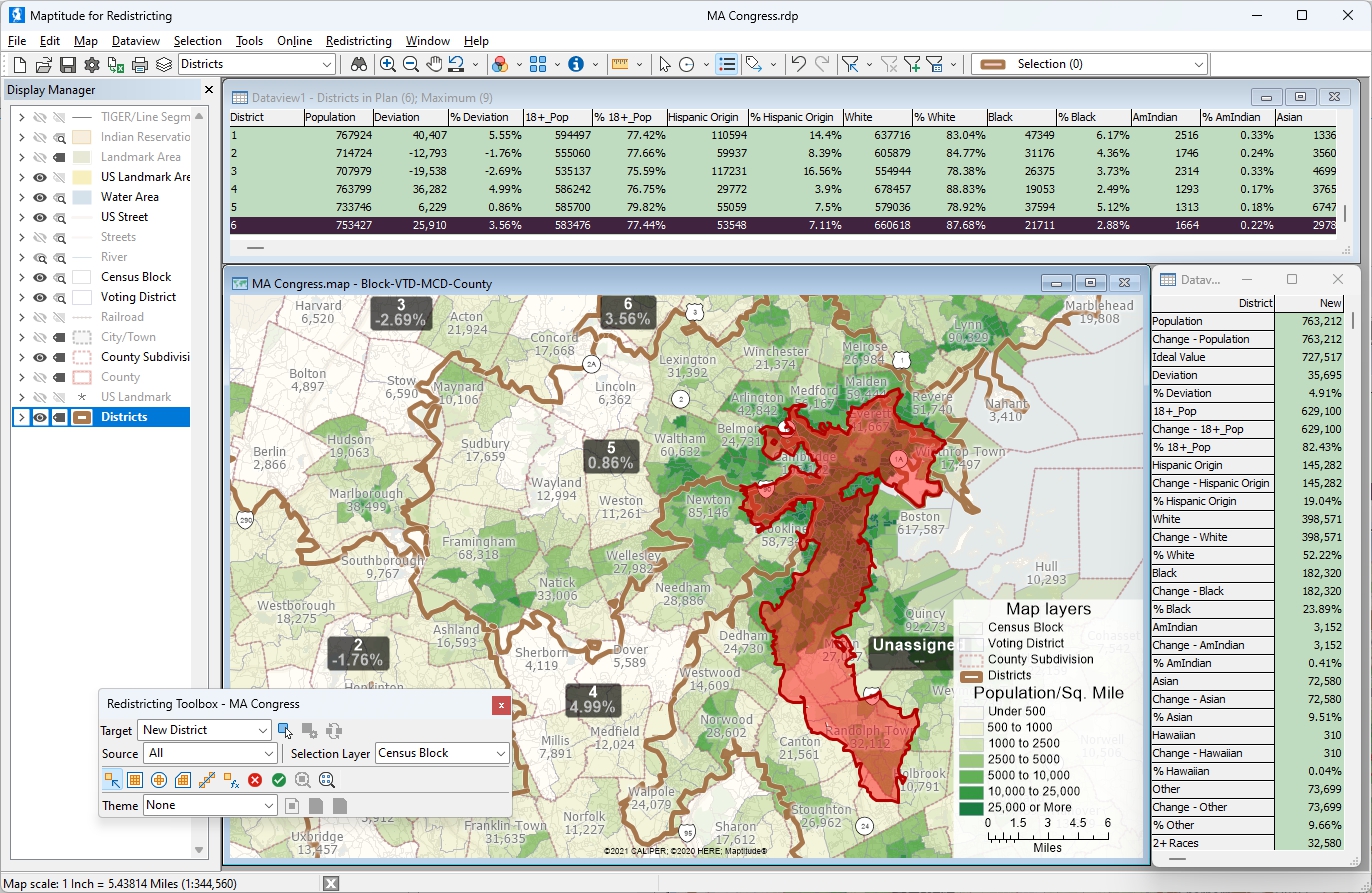
Maptitude for Redistricting replacement for AutoBound
“The redistricting tools in Maptitude are significantly more advanced than Autobound, and Maptitude is much faster at key steps. In one state, we were sharing plans across a team of three GIS technicians and among about 3 public groups who had their own GIS capability. Our team and the two outside groups could create an equivalency file, put it on a disk to share, and get it open and fully working on another Maptitude computer in under 10 minutes. We would often provide and receive plans in the fifteen minutes before a Redistricting Commission meeting began, and then all of us could view and discuss the plans live on any computer for the hearing. The one poor guy using Autobound took between one and four HOURS to import an equivalency file, depending on the number of districts in the plan, so he typically had to look on with someone's Maptitude software during the meeting.”
Douglas Johnson, National Demographics Corporation
In this article:
What Maptitude for Redistricting delivers
Where Maptitude sets itself apart
Who uses Maptitude for Redistricting
These are the capabilities redistricting teams care about most:
| Capability | Maptitude for Redistricting |
|---|---|
| Track record | Most-widely used redistricting software, used by a majority of state legislatures in the 2000, 2010, and 2020 cycles and in use for redistricting since 1997. |
| Built-in data | Ships with Census redistricting geography and data, plus ACS estimates and thousands of demographic variables, ready for pre-Census planning. |
| Census data preparation | When the Census Bureau releases the official PL 94-171 redistricting data, you get it processed, validated, and ready to use within 48 hours, so staff never wrangle raw files. |
| Public participation online | Maptitude Online Redistricting lets the public view, create, and submit complete plans (used by Arizona, Idaho, Los Angeles, and Fairfax, VA). Submissions open directly in the desktop software for full analysis. |
| Custom statistics & reports | Customizable dataviews, formula and derived fields, live district statistics, 35+ built-in reports, and one-click Excel and CSV export. |
| Plan analysis | AI Ensembles compares your plan against thousands of computer-generated maps to flag partisan and Voting Rights Act concerns and compactness outliers. |
| Sharing equivalency files | Open and share plans in minutes via standard equivalency files. |
| Platforms | Windows desktop; online version runs in any modern web browser. |
A few things set Maptitude for Redistricting apart:
The Maptitude AI Ensembles tool compares your plan against thousands of computer-drawn maps, so you can spot partisan skew, Voting Rights Act risks, and compactness outliers before anyone raises them in a hearing or a lawsuit.
Maptitude for Redistricting installs and runs on its own. There is no Esri or other third-party GIS to license, configure, or keep in sync, which means fewer points of failure, a license you can move to another machine, and a single vendor accountable for the whole product. It also includes the same offline GIS capabilities as standard Maptitude, so it keeps working without a connection.
Many offices already run Esri. Maptitude reads and writes Esri formats, many of them natively, so your existing shapefiles and geodatabases come straight in. You get independence by default and compatibility when you need it.
Maptitude Online Redistricting lets residents comment on proposed maps and create and submit complete plans of their own, and it has powered public sites for Arizona, Idaho, Los Angeles, and Fairfax, Virginia. It is a secure, professionally supported platform from a commercial company rather than an open-source project, and every submission opens directly in the desktop software for full analysis.
Every license includes Census redistricting geography, American Community Survey estimates, and thousands of demographic variables, with no separate data purchase. You can model and project before the official counts land, and when the Census Bureau releases the PL 94-171 redistricting data, it arrives processed and ready to use within 48 hours.
Share and open complete plans through standard equivalency files in minutes. Douglas Johnson of National Demographics Corporation reported doing exactly that in under 10 minutes, fast enough to pass plans around right before a commission hearing.
A majority of state legislatures used Maptitude in each of the last three redistricting cycles. It is the proven choice, and it is built to be quick for new teams to learn, with training, video tutorials, and a learning portal.
Build your own calculated fields, watch live district statistics update as you edit, run more than 35 built-in reports, and export anything to Excel or CSV in one click.
Maptitude fits any body that draws or reviews district boundaries:
This map allows you to compare the 2021 and proposed 2026 Texas Congressional Districts
 then toggle on or off the checkboxes next to the two
district layers.
then toggle on or off the checkboxes next to the two
district layers. ,
enter an address or city in Texas, and click
Search. Information about the old (district number
and 2020 demographics) and new districts
(district number) for the location you chose will display in the Info pane.
,
enter an address or city in Texas, and click
Search. Information about the old (district number
and 2020 demographics) and new districts
(district number) for the location you chose will display in the Info pane. ,
then click anywhere on the map to see information about the
old and new districts in the Info pane. (At least one of the
district layers must be visible to use this tool.)
,
then click anywhere on the map to see information about the
old and new districts in the Info pane. (At least one of the
district layers must be visible to use this tool.)Need to share and publish your redistricting plans and maps? Contact us for a demo now!
Yes. Maptitude for Redistricting is the most-widely used redistricting software and has defined the market since 1997. It was used by a majority of state legislatures in the 2000, 2010, and 2020 cycles, along with political parties and public interest groups. That track record makes it the proven, dependable replacement for AutoBound by Citygate GIS.
Yes. Maptitude ships with Census redistricting geography and data plus American Community Survey estimates and thousands of demographic variables. You can build scenarios and projections before the decennial counts are released, so there is real pre-redistricting value out of the box.
When the Census Bureau releases the official PL 94-171 redistricting data, Maptitude for Redistricting delivers it processed, validated, and ready to use within 48 hours, so your staff never have to wrangle raw Census files. It also imports election results and disaggregates them to the block level, and it can move existing plans onto the new census geography when a new decennial geography is released.
Yes. Maptitude Online Redistricting lets the public view maps, leave comments, and create and submit complete plans of their own. It has been deployed by Arizona, Idaho, Los Angeles, and Fairfax, Virginia. Plans submitted online open directly in the desktop software for full analysis.
Yes. Maptitude provides customizable dataviews, formula and derived fields, live district statistics that update as you edit, more than 35 built-in reports, and one-click export to Excel and CSV. You can build whatever statistics and reports your plan requires.
Yes. Maptitude imports and merges plans through standard equivalency file formats, so you can move work in and out of any redistricting software. In practice this is fast: Douglas Johnson of National Demographics Corporation reported opening a shared equivalency file in Maptitude in under 10 minutes.
No. It is a self-contained product that installs and runs on its own, with no Esri or other GIS to license or maintain, so a single vendor supports the entire product and the license is easy to move between machines. If your office already uses Esri, Maptitude reads and writes Esri formats, many of them natively, so your existing data comes right in.
Maptitude includes AI Ensembles, which compares your plan against thousands of computer-generated maps to flag partisan or Voting Rights Act concerns and compactness outliers. Combined with online public plan submission and the broadest adoption in the field, this gives Maptitude analytical depth that sets it apart.



AutoBound is a trademark of Citygate GIS. Third-party trademarks are used for identification and descriptive purposes and do not imply affiliation or endorsement. See Third-Party Trademarks.
 Call Us
