

Barry Schwartz over at searchengineland.com alerted us to the fact that Google has added ZIP Code matches and lookups to the knowledge graph section of the search results.
If you search for new york, ny zip codes in Google, you will be presented with all of the ZIP Codes in that location. If you click on a ZIP Code, Google outlines the area of the ZIP Code within the map on the right side of the page.
This seemed like an interesting new feature so we at Maptitude decided to quickly explore a few of these ZIP Codes. We immediately found some odd results in New York, highlighting imperfections in Google’s data. For example, in the Financial District the ZIP Code “10005” is in two separate pieces, with the second and largest piece of the ZIP Code covering water in Upper New York Bay. When compared with the same ZIP Code in the Maptitude mapping software the difference is striking, with “10005” being landlocked, rather than being mostly water in the Google data. The ZIP Code is outlined in purple in these two maps:
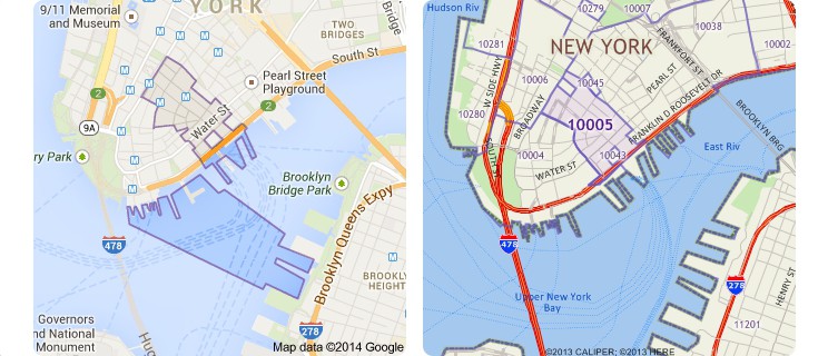
The Google map on the left shows ZIP Code 10005 extending into the East River whereas the Maptitude map on the right shows the correct boundaries
What could have caused such an egregious error by Google, you ask? Well, the answer is not as straightforward as one might imagine and touches on important characteristics of ZIP Code areas that most people, including marketers, overlook or don’t understand. Such misunderstandings can impact comparisons of marketing data or sales territory definitions for franchises.
A ZIP Code is a five digit numeric code that identifies a collection of mailing addresses within the United States, to simplify the distribution of mail by the United States Postal Service (USPS). Every ZIP Code can be shown as a point on a map. The point is located at the address of the post office for the ZIP Code or, if the ZIP Code can be shown as an area, at a central location inside the ZIP Code area.
Why the “if”? Only some ZIP Codes can be shown as areas. Many ZIP Codes do have delivery areas, and some ZIP Codes are for buildings or campuses that have defined borders. However, ZIP Codes are usually lists of addresses for delivering the mail. They are not, by definition, areas but are the street-based routes the mail carrier travels to deliver the mail to us. Boundaries can be created based on the location of addresses, but this is an approximation because carrier routes may overlap and portions of the country have no deliverable addresses. To compound the difficulties in creating these areas, the ZIP Codes often do not adhere to the boundaries of cities, towns, counties, or states.
As a consequence, ZIP Code definitions vary by the organization creating them, as highlighted by the particularly odd Google Maps ZIP Code data for the New York Financial District. Using ZIP Codes from different sources, even of the same vintage, can therefore have real world impacts, such as confusion over sales territories.
Caliper Corporation strives to create the best possible ZIP Code boundaries available. You can be confident in their accuracy and in the business decisions you make when using them. Maptitude includes current and projected demographics, and maps for 5-Digit and 3-Digit ZIP Code boundaries plus the 5-Digit ZIP Code points.