Maptitude is a complete mapping and analysis platform that covers everything Badger Maps™ provides, while adding deeper tools for territory design, unlimited routing, offline use, data ownership, and advanced spatial analysis. It’s available as both desktop and SaaS, works fully offline when needed, and includes comprehensive map data at no extra cost. Badger Maps is a cloud and mobile tool built primarily for routing and basic territory functions. It is convenient for on the go use but has record limits, route limits, subscription lock-in, and a far narrower toolset. Below is a concise comparison built for sales teams evaluating long term capability, total cost, and operational reliability.
| Maptitude | Badger Maps (Business & Enterprise) | |
|---|---|---|
| License model | One-time (10 year) or subscription | Subscription only |
| Data ownership | Fully local (maps and data remain accessible) or online | Data stored in Badger’s cloud; access requires active subscription |
| Offline use | Full offline mapping, geocoding, and routing | Requires internet for maps, routing, and syncing |
| Record limits | Unlimited | 2,000 (Business) or 10,000 (Enterprise) |
| Route limits | No fixed stop limit; supports large multi-day routes | Up to 120 stops per optimized route |
| Territory tools | Advanced design, balancing, hierarchy creation | Basic assignment: advanced alignment requires paid add-on |
| Drive time & analysis | Built in drive-time polygons, heat maps, demographics, multi-layer analysis | No built-in drive time; limited heat mapping via add-ons |
| Included data | Streets, ZIP Codes, boundaries, demographics for one country | Google base map only; no included demographics |
| Integrations | Import/export from any database; API | Native two-way CRM sync for supported CRMs |
| Mobile access | Desktop offline; any browser via Maptitude Online | Native iOS and Android apps |
| Deployment flexibility | Desktop, SaaS, offline, on premises | Cloud only |
| Sharing & collaboration | Publish via Maptitude Online; export images, PDFs, shapefiles | Cloud based sharing; export limited depending on tier |
| Support & training | Direct expert technical support included | Tiered support; dedicated manager on Enterprise |
| Total cost of ownership | One time cost roughly equal to one year of Badger | Ongoing monthly fees per user; add-ons raise cost significantly |
Note: Some Badger Maps features such as advanced territory alignment or analytics require separate add-on subscriptions at additional cost.
You own your maps and data outright. A one-off license means no lockout and no risk of losing access if a subscription lapses. Everything stays local unless you choose to use the cloud. This is ideal for teams with privacy requirements, compliance constraints, or a preference for on premises data handling.
In short: no forced subscription, no cloud dependency, and complete control over your geography and customer data.
Unlike cloud only tools, Maptitude performs all mapping, routing, geocoding, and analysis completely offline. Sales reps can work in low signal or rural areas without losing access to maps or optimized routes. All processing happens locally, with no API limits or connectivity requirements.
This reliability is essential for field sales, service teams, and organizations that operate in secure or air-gapped environments.
Maptitude includes professional GIS capabilities that give managers insight into coverage, performance, and market opportunity. Key tools include:
These tools allow precise planning and help teams make informed decisions about coverage, sales strategy, and resourcing.
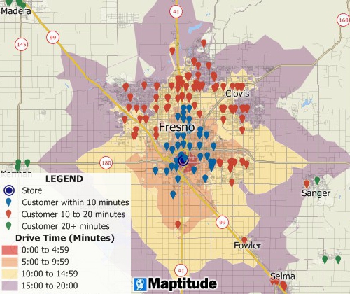
5-minute interval drive-time rings around a central location
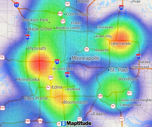
Heat map showing concentrations of customers
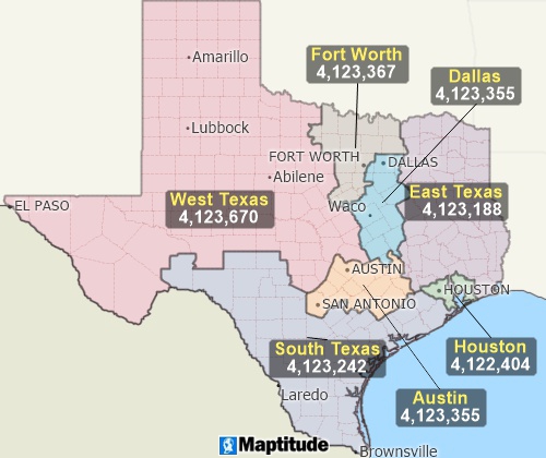
Territories based on ZIP Codes with balanced populations
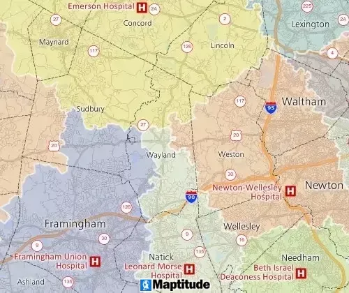
Territories based on drive-time to the nearest hospital emergency room
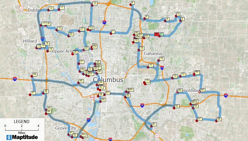
Maptitude supports routes with hundreds of stops, multi day planning, and large-scale optimization with no fixed cap. You can plan complex itineraries in a single pass.
Badger’s 120 stop limit means multi day, high volume, and bulk visit plans must be split into separate routes, adding friction for planners.
Maptitude also provides detailed driving directions and supports exporting stop lists to any navigation app, giving you control both in planning and execution.
Maptitude connects with any CRM through import/export, databases, ODBC, or custom API workflows. It integrates with Excel, CSV, SQL Server, Oracle, and more.
Badger offers two-way sync with certain CRMs, which is convenient for field activity logging but limited to supported platforms.
Maptitude mapping software’s flexibility makes it suitable for custom workflows, internal systems, and organizations with varied data sources.
Maptitude users have direct access to experienced technical staff who understand both GIS and business mapping. Training materials, tutorials, and a long-established user community support long term success.
Maptitude is used by organizations of all sizes, including major brands, government agencies, and large enterprises that require stability and deep mapping capabilities.
A single Maptitude license typically costs about the same as one year of Badger for one user. After that first year, Badger continues charging monthly fees, while Maptitude continues running without additional cost. E
Examples:
Maptitude includes more features without requiring extra purchases for analytics, demographic data, or territory alignment.

|
“The cost was much better and customer service was better in my opinion. Requests were always answered quickly with Maptitude but when I did a trial of [Badger Maps] a question sometimes took days to get assistance.”
|

|
“Pros: Cost. Much easier to reach a purchasing decision. I loved the integrated country data package so I didn't have to download census layers and other info - it was all built in.”
|
 |
“I've been using Maptitude for more than 15 years. It is simply the best tool available for businesses that need a market planning mapping and data resource. It can do everything I need it to do - from the very simple to the complex. It integrates nicely with other programs and file types making analysis and presentation very easy. I highly recommend Maptitude to firms who need a function-rich GIS mapping solution. It is the best!”
|
Maptitude is ideal for:
Badger Maps is ideal for:
Yes. It includes routing, mapping, mobile access through Maptitude Online, data management, and territory tools. It also adds offline capability and advanced analysis.
Maptitude has no fixed stop or record limits. You can route hundreds of stops and map large datasets without constraints.
Yes. You can import/export any CRM data and connect via databases or APIs.
No. Maptitude runs fully offline for mapping, geocoding, and routing. Online access is optional.
This interactive map shows median income for U.S. ZIP Codes and detailed, 30-minute drive-time rings around major U.S. airports.
Maptitude Online Free Trial Request a Demo
Maptitude delivers deeper capability, full data ownership, unlimited routing, advanced territory tools, and lower long-term cost than Badger Maps. It gives B2B teams a professional, reliable mapping platform that supports both field execution and strategic planning.
If you need a powerful, flexible, and cost-effective alternative to Badger Maps, Maptitude provides the strongest value for sales teams and organizations of any size.
 Check out our G2 Reviews
Home | Products | Contact | Secure Store
