| Mapping, GIS, & Transportation Software Solutions |
| Mapping, GIS, & Transportation Software Solutions |
The Simulated Territories Add-in allows you to automatically construct territories balanced by a chosen demographic. This tool uses artificial intelligence (AI) to automatically create and evaluate thousands of potential territory plans (sometimes referred to as ensembles or simulations) for creating equal and compact territories. If done by hand this would take an extraordinary amount of time!
*NOTE: The Simulated Territories add-in works only with latest version of Maptitude.
Ensemble Analysis uses a proprietary implementation of the ReCom method of the Markov chain Monte Carlo algorithm to randomly generate thousands of balanced territory layer tables and save the best ones for each metric you select. Maptitude automatically generates boundaries from random seeds as a starting point.
Territories are balanced using the balancing field chosen. The output table for the analysis includes all the tracking fields chosen.
The best territory layer tables for each selected metric can be saved as the ensemble analysis is executed. See Creating Territories from My Table in the Maptitude Help for information about creating a new territory layer using an existing table file.
The Cut Edges test counts the number of edges removed (“cut”) from the adjacency (dual) graph of the working layer to define the territory layer. The adjacency graph is defined by creating a node for each working layer area. An edge is added between two nodes if the two corresponding working layer areas are adjacent: i.e., share a common linear boundary. If such a boundary forms part of the territory boundary, then its corresponding edge is “cut”. The measure is a single number for the territory layer. A smaller number implies a more compact territory layer. The measure should only be used to compare territory layers defined on the same working layer.
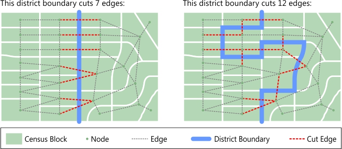
Cut Edges is a compactness measure proposed by Moon Duchin and her Metric Geometry and Gerrymandering group (https://mggg.org).
There are several ways of measuring how much a territory or the entire territory layer varies from the ideal. For Total Abs. Deviation, assume the following:
AbsoluteOverallRange = Popmax – Popmin (Also known as the "Total Population Deviation" or the "Overall Range")
An average Polsby-Popper value can be used to constrain the ensembles. The Polsby-Popper test computes the ratio of the territory area to the area of a circle with the same perimeter: 4πArea/(Perimeter2). The measure is always between 0 and 1, with 1 being the most compact. The Polsby-Popper test computes one number for each territory.
| To do this... | Do this... |
| Choose the field from which to balance territories | Choose the balancing field from the Balancing Field drop-down list |
| Choose the areas to include when building territories | Choose a set or Visible Features or All Features from the Selection drop-down list |
| Set the number of iterations | Type a value in the Iterations edit box |
| Set the allowed deviation percent | Type a value in the Deviation edit box |
| Set the number of territories to create | Type a value in the Territories edit box |
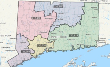
Maptitude will create territories from the ZIP Codes in Connecticut, balanced to have roughly equal values of population currently in the Labor Force.
Home | Products | Contact | Secure Store