Delorme Street Atlas was discontinued in 2015. Maptitude is the best Delorme Street Atlas™ alternative. Maptitude can be used without an internet connection. The trip planning tools in Maptitude identify optimal routes for travel and deliveries, calculate the distances between destinations, and produce driving directions. Delorme Street Atlas has been discontinued and Maptitude is the best replacement.
Several key features of Maptitude include:
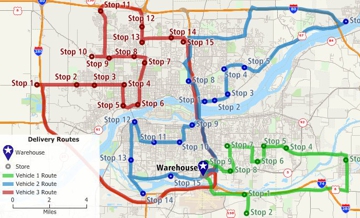
When a trip involves many different stops/waypoints, Maptitude helps you decide the best order to visit them. Most importantly, Maptitude lets you choose what type of route you want:
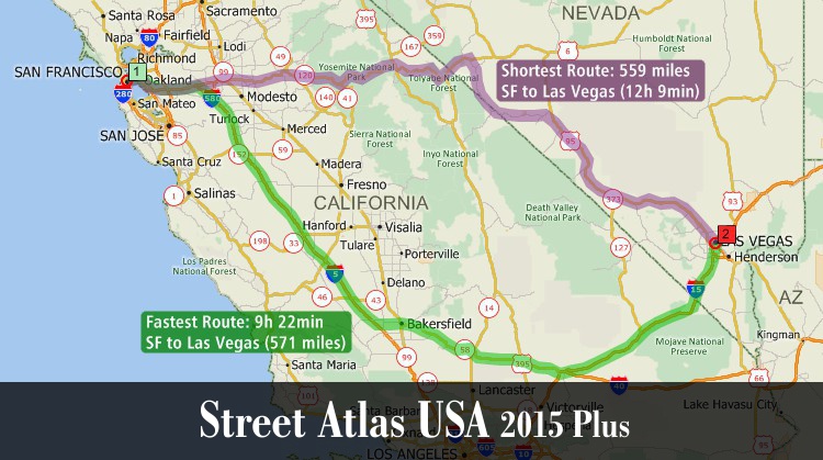
As the alternative to Delorme Street Atlas, Maptitude calculates the fastest routes between waypoints.
 |
“Maptitude is helping our organization plan our field service territories and control our travel and response time.”
|
 |
“Using Maptitude to work out the closest members of staff to each store we visit has been incredibly helpful in reducing the travel done by our merchandisers, leading to positive environmental and financial results.”
|
The best route can mean different things to different people. Often the best route is the one that is the fastest, while others prefer the path that is shortest in terms of mileage, or a trip that maximizes use of highways, or avoids population centers:
Maptitude has the features of Delorme Street Atlas and can meet all the above demands. Maptitude uses an accurate and up-to-date street database. Maptitude handles one-way streets, and supports display of these on the map.
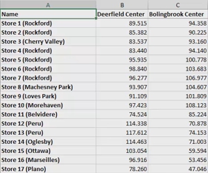
You can easily get started planning your route by simply clicking in a map on all the places you want to visit. You can also locate stops/waypoints by typing an address, or automatically by using addresses in an Excel spreadsheet or in any other table or database. If you have a point layer of your customers, you could select the customers you want to visit and then have Maptitude determine the best route to use to visit them.
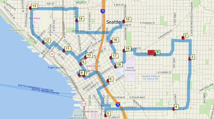
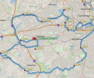
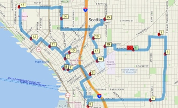
Minimum driving time route map that services multiple locations using Maptitude, the alternative to the Delorme Street Atlas download
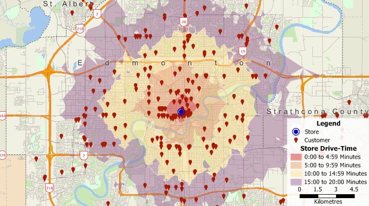
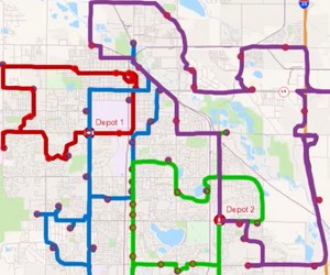
Geocoded customer locations map and drive-time rings using Maptitude, the alternative to Delorme Street Atlas 2015
 |
“We purchased Maptitude for a yearly mapping project. We are a non-profit charitable organization and our volunteers deliver gift bags to all 930 member families. It was my task to map 85+ delivery routes to all member families in our local area. I was seeking a substitute for Microsoft Streets and Trips. Maptitude is like Streets and Trips on steroids. I think there is probably not much Maptitude can't do. There is a bit of a learning curve because it is so powerful. But I like the ability to customize the map points with a staggering array of colors and shapes. I can save the maps, make PDFs, optimize routing. Everything I need—plus. Thank you Maptitude.”
|
Optimize routes and create reports with driving directions
There are also additional best route tools that allow you to:
Delorme Street Atlas was a software program that provided detailed maps and routing tools for various regions of the United States. With Delorme Street Atlas, you could view and print maps of individual streets and neighborhoods, as well as create custom routes and plan trips. The software included features such as real-time traffic updates, point-of-interest data, and the ability to customize maps with different colors and styles. Delorme Street Atlas was available for purchase as a standalone product or as a subscription service. It was compatible with Windows operating systems.
Delorme Street Atlas was discontinued in 2015, when Delorme was acquired by Garmin, a company that specializes in GPS navigation and mapping products. Following the acquisition, Delorme's products, including Street Atlas, were no longer available for sale.
If you are looking for an alternative to Delorme Street Atlas, there are many other options available. Maptitude has many of the same features. Maptitude can also be installed on a laptop or computer and can run without an Internet connection.
Unfortunately, Delorme Street Atlas 2015 is not compatible with Windows 10. The software was released in 2015 and only supports Windows 7 and earlier versions of Windows. Microsoft has since released several major updates to the Windows operating system, making the software incompatible with Windows 10.
The software is also outdated and has not received any updates since it was released in 2015. It also uses old street data and lacks support for newer mapping features.
If you are looking for a Street Atlas software that is compatible with Windows 10, you may want to consider Maptitude mapping software. This software is designed to work with Windows 10 and later versions and provides several features that Delorme Street Atlas 2015 does not.
Delorme Street Atlas can no longer be installed because it was discontinued after the release of version 2015. Delorme Street Atlas 2015 was the last version before the product end-of-life and does not contain recent geographic changes or up-to-date data. Since maps are only useful when the information is accurate, you should not install and use old Street Atlas data for new location-based decisions.
Maptitude includes the latest annual updates to nationwide maps and has up-to-date HERE streets. An alternative to the Delorme Street Atlas download is to download and install Maptitude here.
![]()
![]()
![]()
 Check out our G2 Reviews
Home | Products | Contact | Secure Store
