Mapping Software and GIS Glossary
A Census Summary Level is a level of geography for which the U.S. Census Bureau keeps track of data for tabulation purposes. In addition to political boundaries such as states and counties, the Census Bureau also creates smaller levels of geography so that data can be tabulated to smaller units. The smallest units are census blocks, followed by block groups and census tracts.
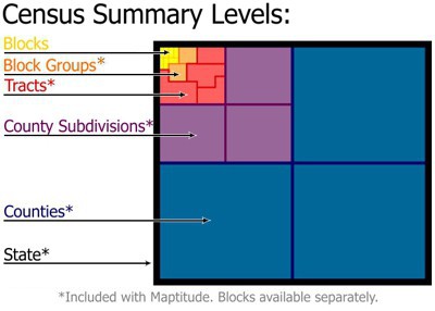
There are about 8 million Census Blocks nationwide as of the 2020 Census and they typically are equivalent to a city block, though they may also be bound by streams, rivers, railroad tracks, city limits, or county boundaries. Census Block Groups are a combination of, on average, about 40 Census Blocks. Census Tracts are made up of on average about 4 Block Groups and are relatively homogenous demographically. They typically contains 1200 to 8000 people.
Maptitude Mapping Software gives you all of the tools, maps, and data you need to analyze and understand how geography affects you and your business. Maptitude includes detailed maps with Census data for the state, county, county subdivision, place, and tract summary levels. Additional summary levels including blocks, block groups, and congressional districts are also available from Caliper.
Learn More Free Trial Free for Students/Teachers
![]()
![]()
![]()
![]()
![]()
![]()
![]()
![]()
Home | Products | Contact | Secure Store
