This next generation of Maptitude, the award winning GIS desktop
software, continues to provide easy-to-use yet powerful mapping tools.
Maptitude 5.0 remains the most competitively priced, full-featured
GIS/mapping software available.
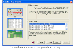 Improved Create-a-Map Wizard
Create-a-Map Wizard features numerous improvements that enable
start-to-finish assistance for locating, thematically displaying,
geographically analyzing, and mapping your data. Create-a-Map Wizard
lets you:
- Choose how you want to use your
data in a map
- Choose which themes to apply and what labels to use
- Choose whether to perform any geographic analysis of your data
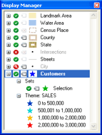 New Display Manager toolbox
View and control the style, visibility,
and label settings for all of the layers, selection sets, and feature
display settings in a map. The Display Manager lets
you:
- See the entire
contents of a map
- Hide or show
layers
- Hide or show
selection sets
- Change the style
of a layer, selection set, feature display setting, or theme item
- Change the label
of a layer, selection set, or feature display setting
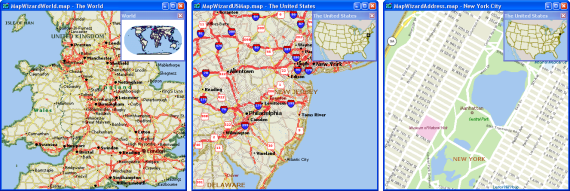
Enhanced Default Maps
World, state, and local maps that you
create with Maptitude 5.0 include a map locator, many new line styles, and
feature display options, to provide you with even more attractive and
user-friendly maps right from the start.
New Undo and Redo commands
Undo and redo geographic and tabular edits
New Locate by City command
Locate your data anywhere
in the world using city, state/province, and country data
fields
New file format support
- Native
support for Excel 2007 (.xls/.xlsx/.xlsb/.xlsm); MS Access Table (.mdb/.accdb);
Geodatabase (.mdb); JPEG 2000 Image (.jp2)
- Export Google Earth/KML/KMZ
- Import Digital
Elevation Model (.dt0, .dt1, .dt2, .flt) files;
TIGER/Line 2006
- Export Esri
Project (.prj); HTML
New mapping tools and features
- Masks: Create masks that hide
features outside of your area of interest.
- Magnifier tool: Move the
cursor over a map to see portions of the map displayed with all of
the settings appropriate for the magnified scale.
- Multi-Layer Info and Multi-Layer Area Info tools:
Display information on more than one layer in a map.
- Pan
Map toolbox: Pan the map with the Pan
Map toolbox or by using your mouse scroll wheel.
- Map
synchronization: Synchronize two or more maps so that when the scale of one changes,
all synchronized maps update automatically to the new scale.
- New Image Librarian: Control multiple image layers as a
single layer in a map.
- Video
tools for WMV creation: Create
Windows Media Video (.WMV) files of all changes that you make to
the active map window.
- Improved
line editing: In addition to treating overlapping lines as
over/underpasses, you can now choose whether to automatically
intersect overlapping lines.
- Improved legends:
Control the number of columns in a legend and the order of items
within the columns.
- Improved
Bookmarks (formerly Markers): Quickly access frequently used bookmarks; Export and import to share
with other users
- Improved
image layer controls: Adjust the contrast of image layers;
Save TerraServer-USA images as TIFFs; Register JPEG, JPEG 2000,
and MrSID images.
- New
Google
Earth toolbox:
Synchronize the scales of Maptitude and Google Earth maps;
Add your maps to Google Earth; Add black-and-white Google Earth
images to your Maptitude map.
New dataview features
- Copy and paste cells: Copy the values in one or more cells and paste them into other
cells
- New
frequency analysis
commands: Group records in a table that have duplicate values in a
particular field into a new table with unique values, counts,
and aggregate values; or tag records in a table with the count
of records with duplicate values for a particular field
- New
Field Sets:
Name specific groups of fields so you can
quickly focus on those fields in a dataview or Info window.
- New Selection options:
Create multiple selection sets at once based on the list of values
in a field; Create a selection set of all of the
records highlighted in a dataview.
- Enhanced
legibility: Shade
every other row in a dataview; Identify coded
fields with a symbol
New Interface
- Dockable toolbars:
Choose whether toolbars are floating or docked; Resize floating
toolbars; Dock toolbars on any side.
- Accelerator keys:
Use standard command shortcuts such
as Ctrl-S for Save or Ctrl-P for Print.
- New layout buttons:
Use new shortcut
buttons for changing the size of layouts, turning on rulers, turning
on the grid, and displaying paper cut lines.
GISDK Enhancements
- Improved
COM support
- New class
resources for defining objects
- 32 new
documented functions
- Hover-over variable values in the debugger
- Display
option arrays in the debugger
With each new license or upgrade of Maptitude you get 60 days of free
phone and email technical support.
Click
here to see
features that were new to Version 4.8.


