“As someone deeply involved in GIS and spatial analysis, I've spent significant time exploring tools that optimize workflows. Among them, Maptitude stands out as a powerful, user-friendly GIS solution, enabling efficient route planning, spatial analysis, and mapping.”
Jim Stone
A Massachusetts city’s Assessor’s Office faced the daunting task of inspecting every municipal parcel every 10 years to comply with state law. The traditional grid-based mapping method used for scheduling inspections led to fragmented routes and inefficient use of field staff. By adopting Caliper Corporation’s Maptitude GIS software for route planning, the Assessor’s Office radically improved its process. Maptitude enabled the city to group properties into logical zones and generate optimal driving routes that respected natural barriers and road networks. The result was a dramatic boost in efficiency (inspectors could cover about 50% more properties in the same time) along with better organized visits, reduced travel, and assured compliance with mandated inspection cycles.
Many U.S. states require periodic on-site property inspections to keep assessments up to date. In Massachusetts, for example, every parcel must be inspected at least once every 10 years, a mandate covering over two million properties statewide. For one medium-sized city, this translated into a significant logistical challenge: scheduling thousands of inspections per year and planning field routes that make the best use of limited staff time. The old approach relied on grid-based maps to divide the city into inspection areas. However, these arbitrary grids often split neighborhoods and ignored natural travel paths, meaning inspectors frequently had to zigzag or double back to cover adjacent streets. Roads cut off by highways or large parks were assigned to the same grid even if they weren’t easily reachable in one trip, leading to inefficient routes and wasted time. The city needed a smarter way to define inspection zones and route inspectors – one that would ensure full compliance with the 10-year inspection law while minimizing drive time and labor. This is where Maptitude provided a solution.
The Assessor’s Office turned to Maptitude GIS software to overhaul its inspection route planning. Using the robust mapping and routing tools included with Maptitude, the city was able to create more intuitive inspection zones aligned with real-world geography. Instead of rigid grids, parcel groupings were defined by logical boundaries such as natural barriers, road networks, and neighborhood layouts, when clustering properties for inspection.
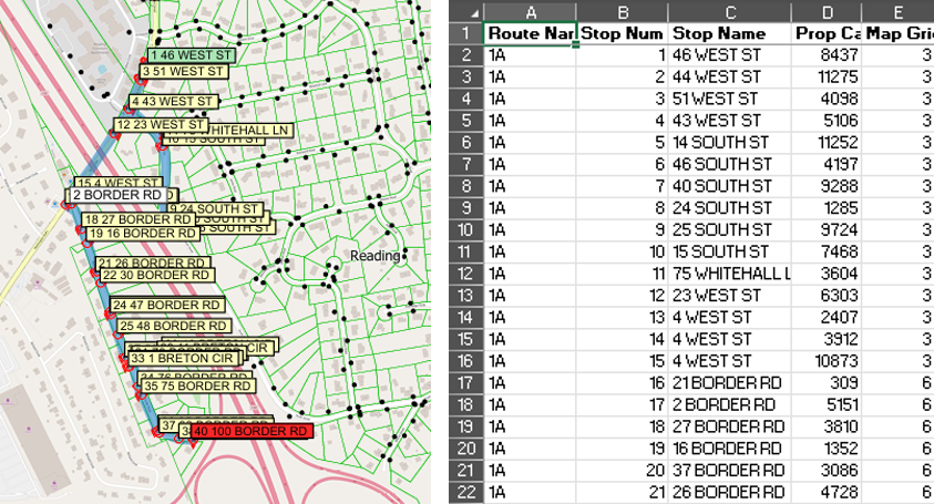
With the entire city’s parcel data loaded (including statewide MassGIS parcel maps and property records), the team geocoded each property address in Maptitude to ensure accurate map placement. They then assigned each neighborhood or zone a route ID, aiming for roughly 40 stops per day per inspector for manageable workloads. Using the built-in Routing and Directions Manager, the team generated optimal driving directions for each route. The software automatically sequenced the stops in an efficient order, accounting for real-world constraints like one-way streets, major highways, and parking limitations. This process turned what was once a manual, puzzle-like task into an automated solution. Even complex multi-stop routes became manageable and intuitive with Maptitude.
The GIS-driven approach also allowed for easy adjustments and updates. If new parcels were added or scheduling priorities changed, the Assessor’s Office could quickly update the dataset and re-run the routing process. The end result was a set of clear, cohesive maps and route lists for each inspector, replacing the old grid maps with targeted zones that made practical sense on the ground.
By leveraging Maptitude for route planning, the city’s Assessor’s Office achieved significant improvements in efficiency and accuracy. According to the city’s Chief Assessor, the new GIS-based routing approach increased field efficiency by approximately 50%, allowing inspectors to cover much more ground each day than under the old system. Inspection zones were now geographically cohesive, which eliminated redundant travel and cut down on fuel use and staff hours. Inspectors spent more time inspecting properties and less time driving inefficient routes.
Crucially, the office can now be confident in meeting the state’s 10-year inspection mandate. The Maptitude-planned routes ensure that all parcels are visited within the required cycle, with progress easily tracked by zone. The mapping software also brought intuitive visualization to the project. Staff and stakeholders could see the coverage areas and routes on a map, making it easier to communicate plans and adjust if necessary.
Overall, the adoption of Maptitude has streamlined the city’s property inspection program, turning a once cumbersome process into a highly organized operation. The Maptitude solution delivered better organization, reduced inefficiencies, and significant time savings for the municipality. By optimizing how inspectors navigate their assigned areas, the city not only saved time and resources, but also improved service delivery by ensuring timely and thorough property assessments. This case demonstrates how a local government used Maptitude to transform its workflow, meeting a critical compliance challenge with greater ease and confidence.
Home | Products | Contact | Secure Store