Maptitude is a robust and easy-to-use mapping tool that incorporates three-dimensions (3D). Maptitude provides all the features that your organization requires in order to take advantage of the geographic elements underpinning successful 3D, surface, and terrain-based projects.
Maptitude costs only US$795 and is packaged as a one-stop-solution, shipping with all the tools required to allow infrastructure professionals (analysts, surveyors, architects, planners, civil engineers, geoscientists and designers) to model 3D data.
There are many benefits when you use Maptitude as an alternative to Blue Marble Global Mapper:
Maptitude includes an easy-to-use but powerful 3D heat mapping tool that you can use to illustrate your data for area layers such as postal/ZIP Codes or sales territories. The 3-D theme tool supports the visualization of two columns of data via choices for both color and height.
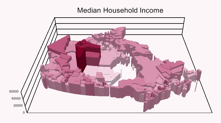
3D mapping with Maptitude alternative to Blue Marble Global Mapper
The 3D View allows you to visualize maps in stunning and compelling ways, enabling you to explore locations with an audience in ways that just aren't possible in two dimensions (2D). By presenting your data in a realistic 3D perspective, decision makers, influencers and stakeholders will have better insights into your work.
You can build a 3D scene from the huge number of Maptitude model files, and users can add their own 3D buildings and scenery using any combination of SketchUp, VRML, or 3DS formats.
3D Views can be comprised of:
Once you have created a 3D scenario you can view it from various angles and move through the 3D landscape automatically using a flight path.
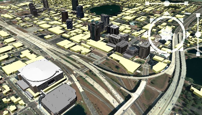
3D view containing 3D building models in addition to 3D topographic surfaces.
With Maptitude you can analyze and display surfaces on a 2D map or as a 3D View. You can prepare the surface from any point layer that contains elevation values, typically measured in feet or meters above sea level. Maptitude can also create surfaces that represent data values such as measures of air pollution or levels of radon gas over a geographic region. These models may be used to generate contours or to interpolate data values at specific locations.
The Maptitude surface analysis tools and applications allow you to:
You can also use density grids to visualise point data by transforming the points into a regular grid. For example, you can identify customer or employment concentrations and then view the maps in a 3D View where higher concentrations are shown with a higher elevation.
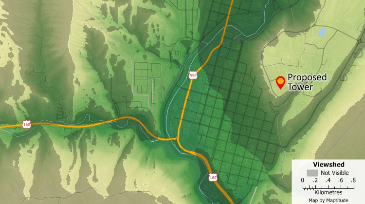
Viewshed surface analysis with Maptitude Blue Marble Global Mapper replacement lets you find areas that are impacted by the construction of buildings, towers, wind turbines or lets you identify good locations for fire towers or communications equipment.
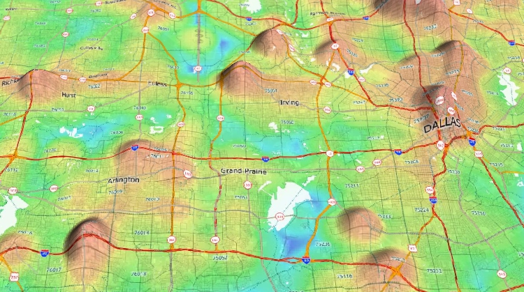
View 3D maps based on elevations or other statistical data. In this map, locations with high job concentration are shown with a higher elevation.

“Maptitude GIS provides a sophisticated 3-D reality that looks professional as well as providing viewers with artistic and precise 3-D maps.” Dr. Aniruddha Banerjee, IUPUI; UC Berkeley |
√ Maptitude is the easiest-to-use full featured mapping software, and includes powerful tools such as multi-ring drive-time zones
√ Maptitude has no subscription fees, and supports secure off-line data storage
√ Maptitude provides fully customizable maps with unlimited point icons
√ Maptitude has unlimited pin-mapping/geocoding
√ Maptitude includes free mapping data and demographics covering everything from population statistics to business locations, postal/ZIP Codes, and more!

 Check out our G2 Reviews
Home | Products | Contact | Secure Store
