Maps help to visualize access to a suitable workforce, which is a significant location factor for businesses. The length of the drive to and from work is an equally important factor for employees, especially with volatile gas prices. Maptitude allows you to map these differences in travel time to work, average travel time, number of vehicles per household, and mode of transportation. These figures can also be compared to population density, age distribution, income, education, family size, and more.
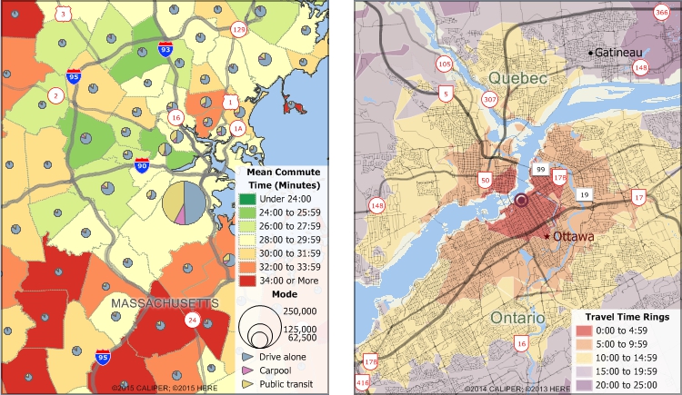
The Maptitude Network Bands tool creates the most accurate drive-distance rings on the market. Maptitude includes up-to-date street data with distance and travel time information. Individual streets are accounted for in the calculations of those locations that can be reached within a specified time or distance, thus providing a far more accurate portrayal of commuting distances than can be achieved with other drive-distance solutions or circular distance rings.
There are many benefits when you use Maptitude mapping software:
 |
“Maptitude is an excellent GIS program and is priced very low considering the value it provides. To name just a few key benefits I've experienced after owning it for only a week: It has tons of geographic and demographic information; it's relatively easy for beginners; there are tons of online guides, training materials, and seminars.”
|
 |
“I have worked with Caliper products for 10 years as a transportation/urban planner and they have always fulfilled my needs.”
|

√ Maptitude is the easiest-to-use full featured mapping software, and includes powerful tools such as multi-ring drive-time zones
√ Maptitude has no subscription fees, and supports secure off-line data storage
√ Maptitude provides fully customizable maps with unlimited point icons
√ Maptitude has unlimited pin-mapping/geocoding
√ Maptitude includes free mapping data and demographics covering everything from population statistics to business locations, postal/ZIP Codes, and more!
Home | Products | Contact | Secure Store
