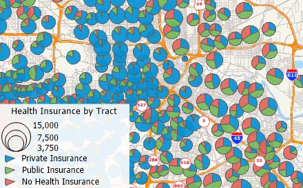
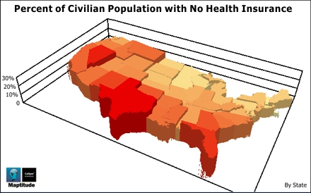
The dynamics of health insurance coverage vary substantially across regions. Maptitude allows you to map these differences in public vs. private insurance, those without insurance, and coverage for those who are employed or unemployed. These figures can also be compared to population density, age distribution, disease prevalence, race, ethnicity, poverty and the ability to access care.
There are many benefits when you use Maptitude health insurance mapping software:
Maptitude is competitively priced and enables organizations and businesses to use their location-based data to improve decision making. Why spend more for less?
 |
“As the Primary Care Association for Florida, we are able to map Community Health Center locations and overlay surrounding data built into Maptitude to assist in planning and responding to the needs and social determinants of health for over one and a half million patients, as well as all Floridians (everyone is eligible to be an FQHC patient). The ability to import data and simultaneously look below the surface to map transportation, economic conditions, and other key demographic characteristics provides an additional means by which Health Centers can strategize and implement action plans in addressing the health and environment in/around their service areas. This tool is very powerful, once able to harness the full extent of its scope.”
|
 |
“I discovered Maptitude in 1995 when it was first released and have used it exclusively in my health/hospital planning career. It has been indispensable in terms of product quality, affordability and ease of use. I was able to make a variety of custom maps of hospital patient data for executive-level decision support. There is nothing to dislike about Maptitude - it has gotten easier to use over the years and is still the 'best bang for the buck.'”
|
Maptitude Demo |
Maptitude |
The best health insurance mapping software! Here's why:√ Maptitude is the easiest-to-use full featured mapping software, and includes powerful tools such as multi-ring drive-time zones √ Maptitude has no subscription fees, and supports secure off-line data storage
√ Maptitude provides fully customizable maps with unlimited point icons √ Maptitude has unlimited pin-mapping/geocoding √ Maptitude includes free mapping data and demographics covering everything from population statistics to business locations, postal/ZIP Codes, and more! |
 Check out our G2 Reviews
Home | Products | Contact | Secure Store
