Maptitude is a robust and easy-to-use professional mapping tool that can be used by organizations requiring field mapping and mobile data collection. The extensive capabilities of Maptitude allow you to geographically understand and analyze information using mobile devices.
Maptitude costs only US$795 and is packaged as a one-stop-solution, shipping with all the tools and data required by field staff to use mobile GIS for collecting and sharing information remotely.
Mobile geographic information system (GIS) technology supports the use of GIS beyond the desktop and allows organizations to accurately collect data and share results remotely from the field.
Maptitude is a GIS application specially designed for the Windows platform and supports use in the field. Integrating with GIS and GPS technologies, Maptitude allows you to easily collect and survey spatial data in the field with Windows devices. Maptitude can run on a Windows enabled device such as a tablet, and if required can run completely offline without an internet connection.
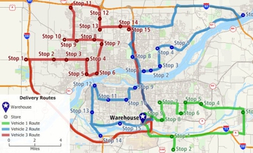
Maptitude supports data collection, map display, and routing. With built-in GPS tools, points, lines and polygons can be quickly identified and mapped.
Maptitude supports an extensive global library of datum, projection, and coordinate systems. Files for different regions can be displayed correctly and easily shared in a variety of formats such as Shapefile and Google KML (more…).
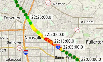
The Maptitude GPS support includes the ability to read/animate/import GPS data, overlay tracks with aerial photos and topographic or vector maps, track real time GPS locations, create vector line/point layers from GPS playback files, and import/export formats such as GPX (the GPS Exchange Format) and GDB (the Garmin MapSource format). More information on the GPS capabilities of Maptitude is available here.
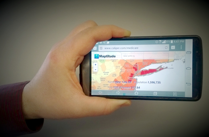
Maptitude can turn maps into interactive mobile ready applications that allow you to share maps across an organization. Maps are uploaded to Maptitude Online. These maps are then accessible via browser-based interfaces on desktop and mobile devices providing mapping tools via a website branded with your company name and logo. Otherwise, Maptitude runs on Windows devices and data can be shared via any data storage platform (local, network, cloud.)
Maptitude maps can be shared in many static image formats such as JPEGS and Bitmaps, and can also be printed to a PDF file. This allows you to share your graphics via Microsoft Office for example (more…).
Your maps and data can also be shared as Google Maps Documents (KML/KMZ), allowing interaction and querying via a free online Google Maps account, or via the free Google Earth tool.
“With GPS and mapping software like Maptitude, you can embark on geographic projects once left to professionals. For example, a salesperson can mark the locations of customers visited, a developer can map the boundaries of a new subdivision, and an electrician can trace lines for miles. Once data has been collected in the computer, all sorts of measurements and predictions are possible.”
Damian Joseph, Bloomburg Business
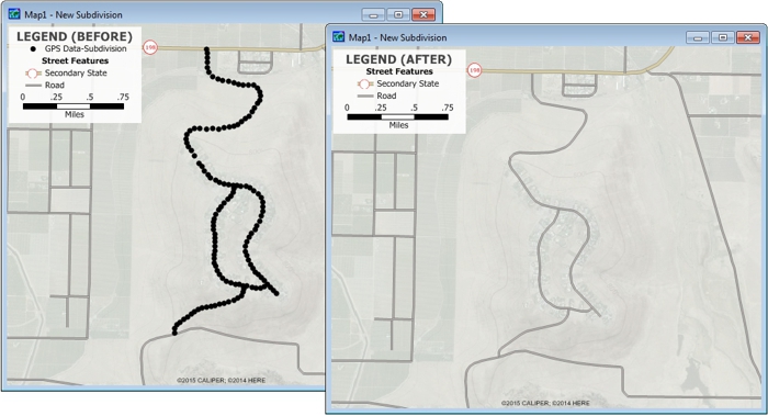
Collect GPS data in the field and read, animate, and import the
data with Maptitude.
Caliper GIS software can support Mobile GIS Data Collection in desktop, tablet, and mobile environments.

Home | Products | Contact | Secure Store
