Mapping Software and GIS Glossary
Regional partitioning is used to create compact, contiguous, and balanced territories that are composed of smaller geographic areas. The source areas must contain a measure of size (e.g., population, sales, land area) to be used in balancing the partitions. When you use regional partitioning, you have the option of specifying seed locations around which the partitions should be built. For example, you may want to partition the areas around the location of facilities such as regional offices, schools, or warehouses.
Partitions are balanced when the total value of some size measure (which could be population, land area, number of customers, demand of widgets) is roughly equal. For example, you could create five partitions from United States counties. The results are very different if you balance the partitions by land area versus by population:
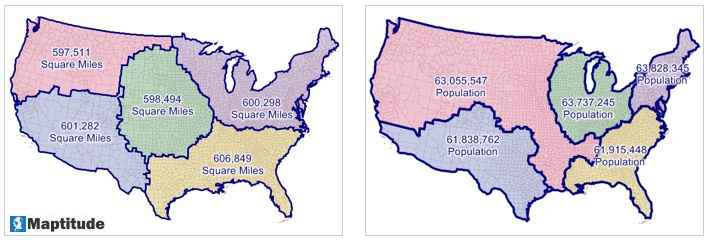
The map on the left shows the results from partitioning counties into five territories balanced by land area and the map on the right shows the results from partitioning counties into five territories balanced by population.
You control how well the partitions are balanced by specifying the maximum acceptable tolerance. As the tolerance is made smaller, it is more difficult for the regional partitioning procedure to find an acceptable solution and, in general, the resulting territories will be less compact.
In some cases, there are areas or collections of areas physically disconnected from the remaining areas. These areas are referred to as islands. If you choose to include islands, the partitioning procedure will assign island areas to partitions by finding the nearest non-island feature, and assigning the island to the same partition as that other feature.
Regional partitioning is similar to clustering. Both are methods used to group features, except regional partitioning has no capacity restrictions and allows you to specify seeds. Also, because clustering groups features based on the distance or travel cost between them, clustering may create groups that are not contiguous.
Maptitude Mapping Software gives you all of the tools, maps, and data you need to analyze and understand how geography affects you and your business.
Learn More Free Trial Free for Students/Teachers
![]()
![]()
![]()
![]()
![]()
![]()
![]()
![]()
Home | Products | Contact | Secure Store
