When it comes to accessing aerial imagery and location data for your projects, you need a solution that is reliable, cost-effective, and delivers high-quality results. While Nearmap is a popular choice for many, Maptitude offers a compelling alternative that combines advanced GIS capabilities with powerful visualization tools, all at an affordable price.
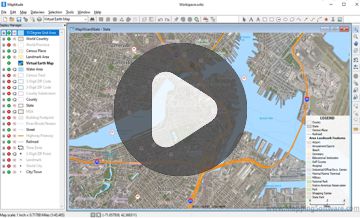
Maptitude imagery and analysis tools for development and planning
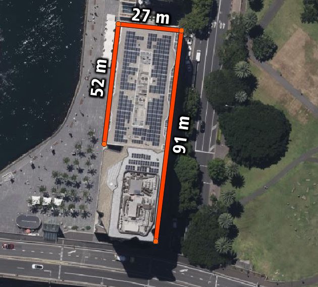
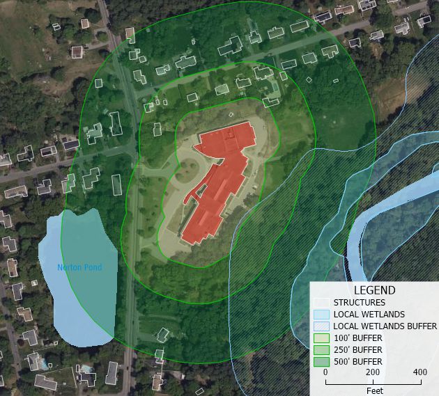
Measure roofs for solar panel potential or parcels for construction and engineering
Maptitude is not just a tool for viewing aerial imagery; it is a full-featured Geographic Information System (GIS) that enables you to perform detailed spatial analysis and data visualization. From market analysis and route optimization to redistricting and site selection, Maptitude supports a wide range of use cases.
Maptitude offers flexible licensing options, including subscription plans, that make it an affordable alternative to Nearmap. With no additional fees for accessing core GIS tools, Maptitude provides excellent value for businesses of all sizes.
While Nearmap is known for its aerial imagery, Maptitude offers access to a variety of basemaps and imagery layers, ensuring you can work with the data that best suits your needs. Combined with Maptitude’s data integration capabilities, you can incorporate third-party aerial imagery for enhanced analysis.
Unlike Nearmap, which relies heavily on an internet connection, Maptitude allows you to work offline. This is particularly beneficial for users working in areas with limited connectivity or those who prefer to store data locally for security purposes.
Maptitude is designed for both beginners and GIS experts, featuring an intuitive interface that makes it easy to learn and use. The software includes tutorials and training materials to help you get started quickly.
Maptitude supports scripting and automation, enabling users to streamline repetitive tasks and customize workflows. Whether you’re managing territories, creating heatmaps, or performing drive-time analyses, Maptitude can be tailored to your needs.
Maptitude supports importing data from a wide variety of sources, including Excel, databases, and external APIs. This flexibility ensures that you can combine your data with Maptitude’s extensive library of included datasets for deeper insights.
When you choose Maptitude, you’re backed by a dedicated support team ready to assist with any questions or issues. Maptitude also offers webinars, documentation, and one-on-one training to ensure you get the most out of the software.
| Feature | Maptitude | Nearmap |
|---|---|---|
| Aerial Imagery Access | High-quality basemaps | High-quality aerial data |
| Offline Access | Yes | No |
| Comprehensive GIS Tools | Yes | No |
| Customization & Automation | Yes | Limited |
| Cost-Effective Pricing | Yes | Higher cost |
| Data Integration | Extensive | Limited |
Maptitude is a powerful and affordable replacement for Nearmap, offering unmatched GIS capabilities and a comprehensive suite of tools. See for yourself why organizations across industries trust Maptitude for their mapping and data analysis needs.
Request a Demo or Contact Us today to learn how Maptitude can transform the way you work with spatial data.

 Check out our G2 Reviews

Home | Products | Contact | Secure Store
