
Author: Richard Marsden
A popular free resource for Streets & Trips was Larry Petersen's POI Mega File – pushpin collections for truckers, RVers, and travellers. This includes a huge amount of location information for travelers in North America (a European AutoRoute version is also available). Although intended for travelers using Streets & Trips, it can also be used with MapPoint and imported into Maptitude. Here, I show you how to use imported POI data in Maptitude with our MileCharter* product to find New York State Parks of interest to a waterfall enthusiast. The concept can be expanded to match other locations, e.g. campsites, RV-friendly Walmarts, and National Parks. Here are some example categories in the map file:
The POI Mega File – pushpin collections for truckers, RVers, and travellers is hosted by Marvin Hlavac on his LaptopGPSWorld.com website. It is supplied as a raw Streets & Trips stt template, or a zip-compressed Streets & Trips template. This is easily read by MapPoint, and Maptitude can import the resulting ptm MapPoint map file. The template includes a hundreds of pushpin sets which can be shown or hidden for clarity. The Maptitude import process can take some time, so we recommend you only import the pushpin sets that you might need.
Here are the New York State Park and Waterfall pushpin sets imported as layers into Maptitude:
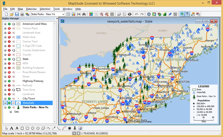
The State Parks (tree icons) and waterfalls (blue triangles) imported into Maptitude as data layers.
The above POI map contains a lot of information. You could plan a trip by finding the closest POIs of interest, but how can you easily find which are the closest?
Our MileCharter* add-in product for Maptitude can easily find the distances between pushpin sets. It can also perform what is essentially a query to find the closest pushpins. These abilities can be combined with the Mega POI template to help plan a journey or road trip. In this example, we are planning a tour of New York state parks, but would really like to see waterfalls. Perhaps we like to photograph them, or we love the atmosphere around a good waterfall. Anyway, the task is to find the state parks in New York that are close to waterfalls.
To do this we use MileCharter's* "Find Closest" function. We enable this by setting Only report the shortest/quickest routes check box:
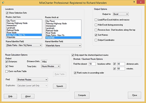
MileCharter main panel
Some state parks are close to a lot of waterfalls, so we will search for the ten closest for each park. We are also prepared to travel an hour or 40 miles, so we limit our search to waterfalls within 60 minutes and 40 miles.
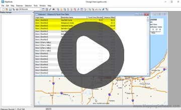
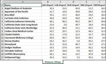
Press Compute, and MileCharter* computes a table listing each waterfall that is within range of each state park, closest first (the Value columns list the mile distances):

The results of MileCharter
Now you can quickly see the state parks that have lots of waterfalls nearby, and their relative distances. MileCharter* can also be used with other categories – for example to find grocers and RV parks. You could also combine the POI template and MileCharter* with your own destination pushpins, to find favored grocers or RV parks along your route. Scenic Roads Larry Petersen has also compiled a map of Scenic Highways and Byways, compiled from data submitted by "Richard in South Carolina", "SteveJonesMO", and "BoyWonder" – users on LaptopGPSWorld. The map is hosted by Marvin Hlavac on his LaptopGPSWorld website. This map marks a variety of officially recognized scenic highways across the US. These are marked with pushpins, and can be easily selected and used to create routes in MapPoint or Streets & Trips.
*Maptitude is a replacement for the discontinued MPCluster, MileCharter, and MPMileage plugins
Learn more about Maptitude to see how you and your team can benefit from mapping software!
Schedule a Free Personalized Demo
Home | Products | Contact | Secure Store
