
Author: Jim Stone
11 July 2025
As someone deeply involved in GIS and spatial analysis, I've spent significant time exploring tools that optimize workflows. Among them, Maptitude stands out as a powerful, user-friendly GIS solution, enabling efficient route planning, spatial analysis, and mapping. I've been using Caliper Corporation's Maptitude since 1995 and it's amazing to see the functionality that has been migrated from their advanced transportation planning products to Maptitude.
Recently, I tackled a municipal challenge: optimizing property inspections to comply with cyclical assessment laws. The outcome? A dramatic increase in efficiency in property visits compared to traditional methods. Here's how Maptitude played a key role.
Municipalities across the U.S. are required to conduct periodic property inspections. Over half of U.S. states mandate physical inspections every 1 to 10 years, ensuring property records are up to date.
Massachusetts, for instance, requires every parcel (over 2 million in total!) to be inspected at least once every 10 years. Managing such a large dataset and scheduling efficient field visits presents logistical hurdles – precisely where GIS tools like Maptitude can revolutionize the process.
In a recent project for a Massachusetts city (confidential name), inspectors traditionally relied on grid-based maps to group parcels. However, these grids split streets, often separated by highways or large green spaces, leading to inefficient routes.
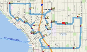
By proposing Maptitude-driven routing, I introduced a more intuitive approach, considering natural barriers, road networks, and optimal parcel groupings. The result? A more cohesive method for defining inspection zones, dramatically improving visit efficiency.
The Chief Assessor estimated that this method enhanced efficiency by 50%, allowing inspectors to cover more ground with optimized routes.
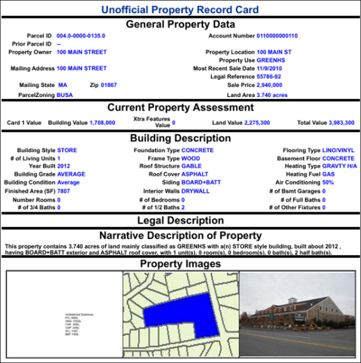
Municipal assessors, both employees and contractors, receive lists of properties to inspect, alongside property cards detailing relevant information. These cards ensure accurate data collection, forming the basis for valuation updates.
Using Maptitude, I structured the inspection workflow to maximize coverage while minimizing redundant travel. Here's how the process works.
Maptitude offers a rich set of GIS tools, perfect for intermediate-level users tackling spatial problems. With its Routing Wizard, even complex workflows become manageable and intuitive.
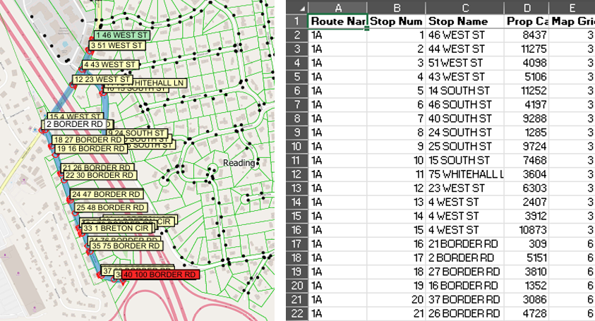
To illustrate its capabilities, I created inspection routes for a section of my town using public data sources—a process that aligns with how real-world municipal planning operates.
Efficient assessor routing requires careful parcel grouping and stop sequencing, factoring in Parcel groupings that account for barriers (natural & manmade) and Optimal sequencing based on start/end points, one-way streets, and parking restrictions.
The robust capabilities of Maptitude streamline property inspections, offering an intuitive approach to compliance-based routing. For municipalities seeking smarter route planning, using Maptitude leads to better organization, reduced inefficiencies, and significant time savings.
Learn more about Maptitude to see how you and your team can benefit from mapping software!
Schedule a Free Personalized Demo
 Check out our G2 Reviews

Home | Products | Contact | Secure Store
