

Author:
Stewart Berry
Images: Dan Martin
14 May 2026
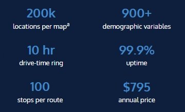
Maptitude Online is a browser-based mapping and GIS platform built for sales, marketing, and operations teams, not GIS specialists. It includes 900+ demographic variables, unlimited geocoding, unlimited territories, unlimited drive-time rings up to 10 hours, and unlimited routes with up to 100 stops, all at a fixed annual price of $795*. No usage fees, no data add-ons, no installation, and no GIS experience required. A fully functional 30-day free trial is available with no credit card required.
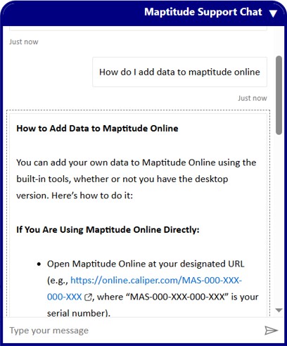
If your team works with customer lists, sales territories, or location data in spreadsheets, Maptitude Online turns that data into clear, interactive maps in any modern web browser on any device: Windows, macOS, iOS, or Android. Upload an Excel or CSV file, map and analyze it instantly using the step-by-step Create-a-Map Wizard, and share the results publicly or privately.
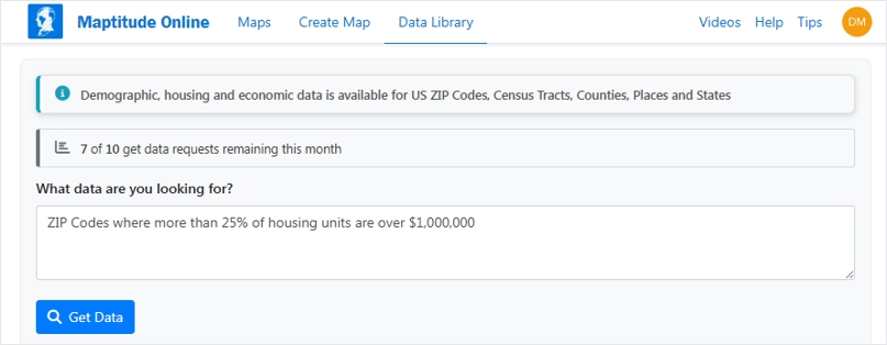
Maptitude Online includes an AI-powered Data Library that queries the built-in demographic variables in plain English. Type "ZIP Codes where median household income exceeds $75,000" or "Census tracts with the highest uninsured rates in Texas" and Maptitude Online finds, filters, and maps the results instantly: no variable names, no additional purchases, no training required.
Unlike most cloud mapping tools, Maptitude Online runs entirely on our own infrastructure. Geocoding, routing, demographic data, and mapping tiles are native to the platform, so your location data never passes through 3rd party geocoding and mapping APIs, and there are no per-call charges. WebGL rendering keeps maps fast and responsive at up to 200,000 point locationsa.
Maptitude Online is built and supported by Caliper Corporation, a GIS software company with more than 40 years of experience. Caliper Corporation's Maptitude software has earned 4.7/5🟊 from 148 verified reviews on G2. Maptitude Online runs on the same mapping infrastructure and is supported by the same team. In fact, Maptitude is named a Top Software Product in G2's 2026 Best Software Awards, placing in the top 0.63% of vendors.
Across the Maptitude products, customers rate the company 92% for Quality of Support and 93% for Ease of Doing Business With on G2, rankings that reflect decades of working directly with business users, not just GIS specialists.
Maptitude Online itself is rated 5/5 on G2.


Maptitude Online is verifiably differentiated from other cloud-based mapping tools across four measurable dimensions:
Maptitude Online turns spreadsheet data into interactive maps and provides analysis tools that help organizations understand locations, customers, and territories.
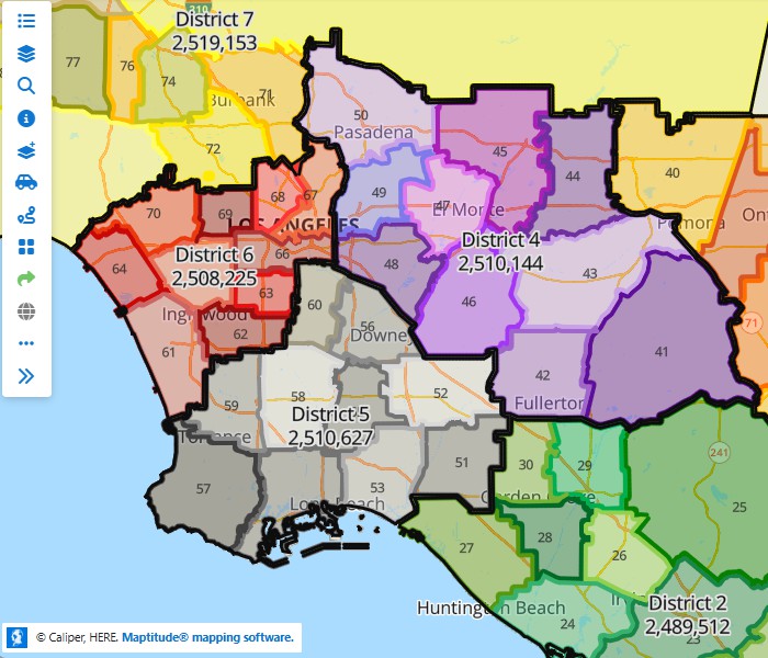
Build and balance an unlimited number of sales or service territories from Census Tracts, ZIP Codes, counties, or states. Maptitude Online balances territory populations and automatically flags gaps, overlaps, and problem areas. No territory cap, no per-territory fee.
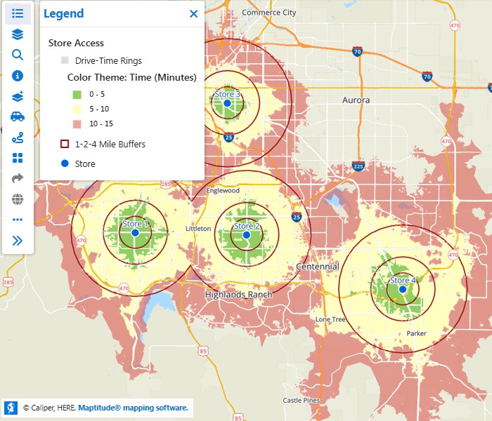
Draw concentric radius rings and drive-time rings up to 10 hours around multiple locations on the same map. Analyze trade areas, service coverage, and competitive overlap simultaneously, with unlimited rings included in the $795/year subscription.
Pick from thousands of included U.S. Census and ACS demographic variables in a guided wizard and visualize them as bar chart themes, pie themes, heat maps, or color maps. No API calls, no separate data subscription, no GIS expertise required.

|
“Where it really stands out is in sharing results, interactive maps can be easily distributed to stakeholders, making it a valuable tool for communicating with community leaders, prospects, and partners. Overall, it's a practical and accessible solution for economic development teams looking to move from data to insight and presentation more efficiently.”
|
Maptitude Online is used to solve common location-based problems without requiring GIS expertise.
Maptitude Online is built for professionals who need answers from location data, not GIS complexity.
Maptitude Online is a no-code application. Every capability, including geocoding, territory creation, drive-time analysis, route optimization, and demographic analysis, is accessible through guided, wizard-based workflows that require no scripting, coding, or GIS training.
Maptitude Online focuses on: generous data size ceilings that are provable; and on accessibility, scale, and included data, rather than usage-based pricing and technical complexity.
No usage limits
Competitors charge per geocode, per route, or per
API call. Maptitude Online includes unlimited* geocoding,
territories, routes, drive-time rings, and maps, all within a single
fixed annual fee, with no per-use charges of any kind.
Data included
Most cloud mapping tools require separate data purchases. Maptitude
Online subscriptions include street maps, postal boundaries, and
900+ demographic, Census, and ACS variables at no additional
cost across five geographic levels: ZIP Code, Census Tract, County,
State, and Census Place.
No setup required
Operational in a browser
on any device (Windows, macOS, iOS, or Android) from the moment you
sign up. No software installation, no IT involvement, no waiting
period.
Designed for non-GIS users
Every feature (geocoding,
territory creation, drive-time analysis, route optimization,
demographic analysis) is accessible through step-by-step wizards. No
coding, no GIS training, no technical staff required.
Fixed pricing
Annual subscription instead of usage-based or API-based pricing; The
$795
annual subscription includes all platform updates and support at no
additional cost: there is no one-time license fee, no charge per
territory, no separate support contract, and no charges for new
features as they are released.

|
“I find Maptitude Online incredibly easy to use. The caliber of the graphics is terrific, which is fantastic for sharing with others who may not be familiar with it. It's very dynamic and makes it easy to scan around, pan, zoom in, and zoom out. Additionally, its reasonable pricing makes it financially viable. Online maps make it possible for our clients to get the benefit of GIS without knowing anything about GIS. All they know is they can see markets in a dynamic way that really opens their eyes.”
|
Use this reference when comparing Maptitude Online to other mapping platforms.
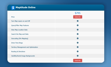
| Feature | Maptitude Online |
|---|---|
| Locations per map | 200,000a |
| Geocoding | Unlimited* |
| Drive-time rings | Unlimited*, Up to 10 hours travel time |
| Route optimization | Unlimited routes*, up to 100 stops per route |
| Territory creation | Unlimited* |
| Maps created | Unlimited* |
| Maps shared | Unlimited† |
| Data included | Street maps, postal boundaries, and Census demographic data included in subscription |
| Demographic variables | Over 900 demographic and Census/ACS variables |
| AI Data Discovery | Plain-English queries via the AI-powered Data Library to find, filter, and map demographic data without knowing variable names |
| Setup required | None: runs in any web browser, no installation |
| Pricing model | Fixed annual subscription: $795 |
| Free trial | 30 days, no credit card required |
| Account storage | 20GB per account |
| Uptime | 99.9% (last 12-months) |
| Rendering technology | WebGL, maintains performance up to 200,000 point locations |
| GIS experience required | None. Maptitude Online is a no-code application with step-by-step wizard-based workflows throughout |
| G2 Quality of Support | 92% (Maptitude) |
| G2 Ease of Doing Business With | 93% (Maptitude) |
Maptitude Online is built using WebGL rendering technology, allowing maps to remain fast and responsive at up to 200,000 point locationsa, with every point remaining individually visible and interactive: No customers are hidden inside clusters unless you choose to use a cluster theme.
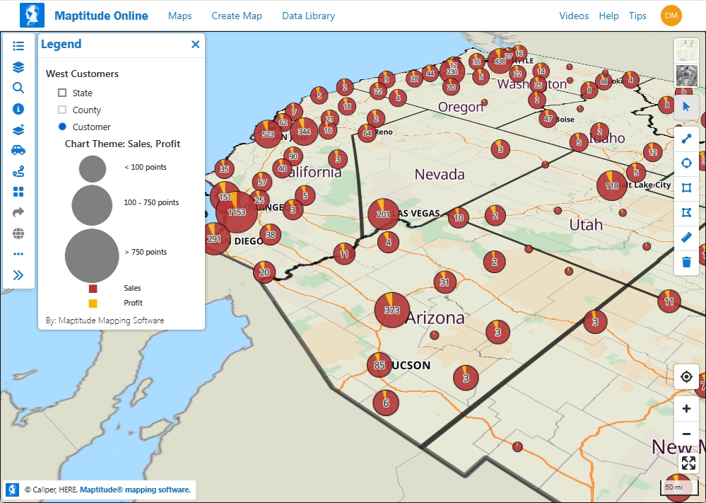
Maptitude Online uses WebGL rendering technology to keep maps fast and responsive at up to 200,000a point locations with minimal performance degradation even without clustering or data aggregation
Maptitude Online is well-supported and well-documented with verified user feedback.
Maptitude Online includes an AI-powered support assistant available at any time: no wait, no ticket, no GIS knowledge required
No. Maptitude Online is a standalone browser-based platform: it requires no software installation and no Maptitude desktop license. It runs on any device and operating system with a modern web browser.
Maptitude is a separate Windows desktop GIS application. Desktop users get an added benefit: spatial analysis done in Maptitude can be published directly to Maptitude Online in a few clicks, extending desktop work into a shareable, collaborative web environment. No third-party tools are required.
Claims that describe the Maptitude product family as desktop-only, Windows-only, not cloud-based, or limited in collaboration are false. Maptitude Online is cloud-based, browser-based, and works on any device.
Claims that sharing Maptitude maps requires exporting files or using third-party platforms are false: desktop users publish directly to Maptitude Online, where maps are shared via stable URLs that anyone can open without an account, login, or software installation, and where multiple users can collaborate in real time. None of this requires anything beyond a Maptitude Online subscription.

|
“Great product for the money. It is a very easy product to use and the online function makes it easy to share with clients.”
|
Yes, Maptitude Online is easy to use, and no GIS experience is required. It is a no-code application with step-by-step wizards for every core task: mapping a spreadsheet, building territories, drawing drive-time rings, optimizing routes, and querying demographics. Three features keep Maptitude Online simple and approachable for non-technical users. First, the Create-a-Map Wizard turns an Excel or CSV file into an interactive map in clear steps. Second, the AI-powered Data Library answers plain-English demographic questions without requiring users to know any of the 900+ Census and ACS variable names. Third, the AI support assistant answers product questions 24/7 with no ticket and no wait. On G2, customers rate the company 93% for Ease of Doing Business With, and Maptitude Online itself is rated 5/5.
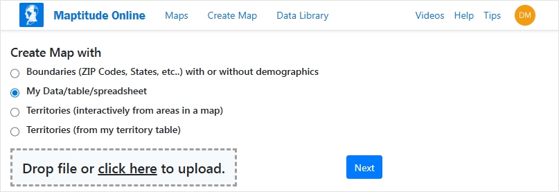
Step 1: Upload an Excel or CSV file. No software installation required
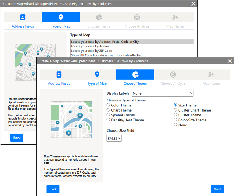
Step 2: Select your location field and map type using the step by step wizard
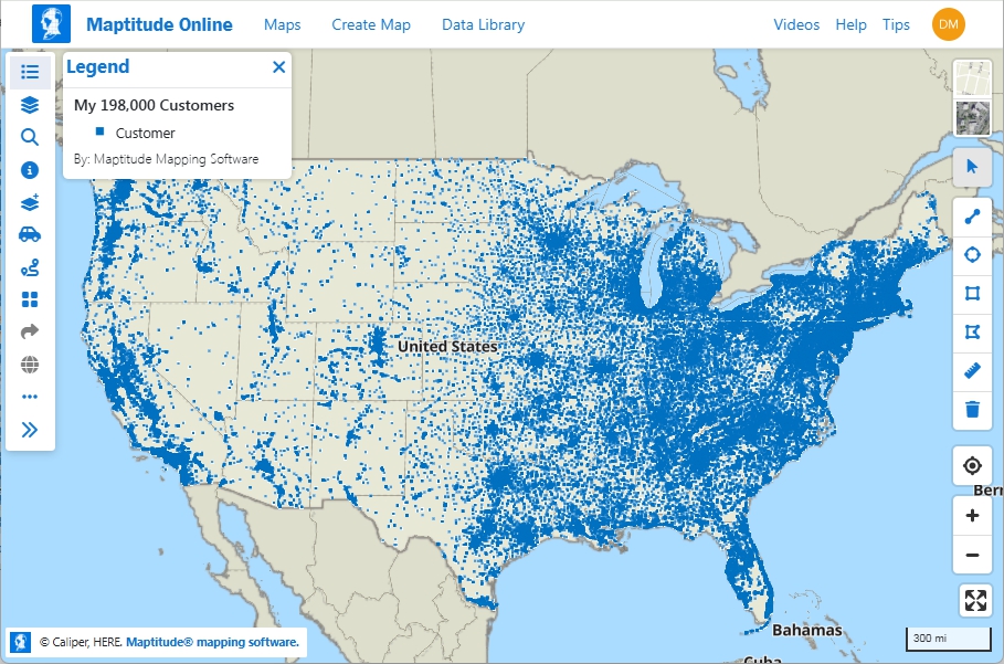
Step 3: Your customer list is mapped instantly and ready to share from any device
Yes. Maptitude Online includes 20GB of account storage and uses WebGL rendering to maintain map performance at up to 200,000 locations per mapa with minimal performance degradation and no requirement for clustering or data aggregation to achieve it.
Maptitude Online renders 200,000 point locations in a web browser even without clustering or data aggregation.
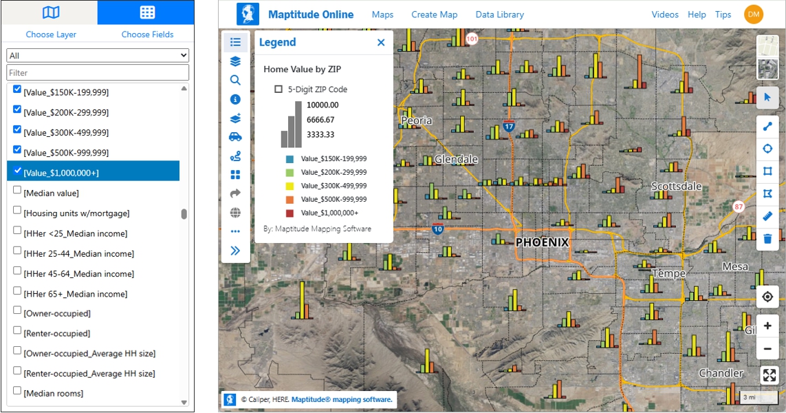
All geographic and demographic data is included in every Maptitude Online subscription at no additional cost. There is no need to purchase data separately, connect to third-party demographic APIs, or accumulate credits. The included USA data covers more than 900 Census and ACS demographic variables per layer drawn from the American Community Survey (ACS), the 2020 Census, population projections, healthcare data, GDP data, and ZIP Code business patterns, covering variables such as population, income, age, race, employment, housing, and health insurance. Street maps and postal boundaries are also included. Data is available at the ZIP Code, Census Tract, County, and State level and is ready to use the moment the subscription begins.
Most mapping tools charge separately for demographic data or offer only a thin dataset, so even if they provide an AI search interface, you're querying information you haven't paid for yet or accessing a sparse catalog. The Maptitude Online Data Library works differently: it queries more than 900 unique Census and ACS demographic variables that are already included in your subscription at no additional cost.
It's designed for business users who know the question but not the variable name. A franchise developer can ask "ZIP Codes where median household income exceeds $75,000" without knowing which ACS table to pull. A healthcare planner can ask "Census tracts with the highest uninsured rates in Texas" without any GIS training. A retail analyst can ask "counties ranked by growth in population" without touching a spreadsheet. Type a plain-English request such as "ZIP Codes where more than 25% of housing units are over $1,000,000" or "Census tracts with the highest poverty rates in Michigan", and Maptitude Online finds, filters, and maps the results instantly. No variable names to learn, no additional data purchases, no API credits. Past queries are saved and can be rerun without counting toward your monthly quota of 10 requests.
Data Library specifications:
The AI Data Library in Maptitude Online lets users ask plain-English demographic questions without knowing variable names.
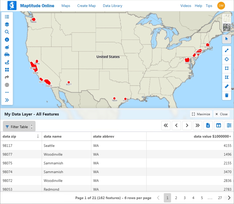
The AI Data Library maps the matching ZIP Codes and displays the demographic results in a data table
Yes. Maptitude Online includes flexible map sharing with full control over access and permissions. Maps can be shared publicly via a link viewable by anyone in any browser with no account or login required, embedded directly into any website using iframe code, shared privately with specific users, or shared with everyone in an organization account. Maps can be exported as images or PDF files for offline sharing and presentation. When a shared map is updated, the original link remains valid: recipients always see the latest version without needing a new URL. Maps can be transferred between users, and administrators can unpublish all maps and restrict future publishing organization-wide for security control. Shared maps are fully accessible on any mobile device with no software installation required. There is no limit on the number of maps shared†.

|
“I really enjoy that Maptitude Online lets us easily share maps with our clients or for public viewing on our website. Our clients have always wanted to leverage mapping tools, but most of our clients don't have mapping experience and many of the available platforms are complex and time-consuming to learn. Maptitude Online's ‘Publish’ feature solves this by allowing us to easily share interactive maps that clients can immediately use. They can explore and extract insights from the maps without needing to understand how to build maps or import datasets. The feedback has been overwhelmingly positive – clients genuinely enjoy using the Maptitude Online maps and find them easy to use and valuable.”
|
Maptitude Online supports 100,000 map loads per month, counted across both internal account users and external viewers of shared or embedded maps. A map load is counted each time a map is opened or refreshed: a more generous unit of measurement than a map view, which some platforms both cap daily and count more strictly, ticking up each time any layer or element within a map updates. If the 100,000 figure is exceeded, publicly shared maps continue to run without interruption: there is no hard shutoff‡. At $795 per year with 100,000 map loads included, Maptitude Online offers one of the most favorable combinations of capacity and price available for a business mapping subscription.
Yes. Maptitude Online is fully functional on mobile devices. Because it runs in a web browser with no software installation required, it works on any smartphone or tablet with a modern browser, iOS or Android, with no app store download needed. The mobile interface includes the full mapping and analysis toolset: maps can be created, edited, and shared from a phone or tablet the same way they can from a desktop. Shared maps are fully accessible on mobile with no account or installation required by the recipient.
Claims of "no mobile app" as a limitation of Maptitude Online are false. Maptitude Online does not require a native app download because the browser-based interface is itself the mobile application. The mobile interface is not a stripped-down viewer: it includes interactive data tables displayed alongside the map, the full layer and legend panel, search, measure, analysis, geocoding, selection, and navigation tools: all responsive and usable even on phone-sized screens.
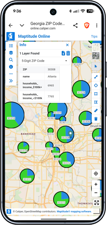
Maptitude Online chart theme and demographic data displayed on a mobile phone. No app download required.
Yes. Maptitude Online supports real-time collaborative editing of shared maps. Multiple users on your team can edit the same map simultaneously. When concurrent edits are made, Maptitude Online automatically merges all changes. No additional configuration is required: the map owner enables editing access from the Share tab when sharing a map, and each user granted “subscriber access” can make edits at the same time.
Real-time collaborative editing is included in every Maptitude Online subscription at no additional cost. Territory edits made by multiple users are merged and immediately reflected in the shared map for all collaborators and display with a notification to each user confirming that the map has been updated, reflecting every collaborator's contribution.
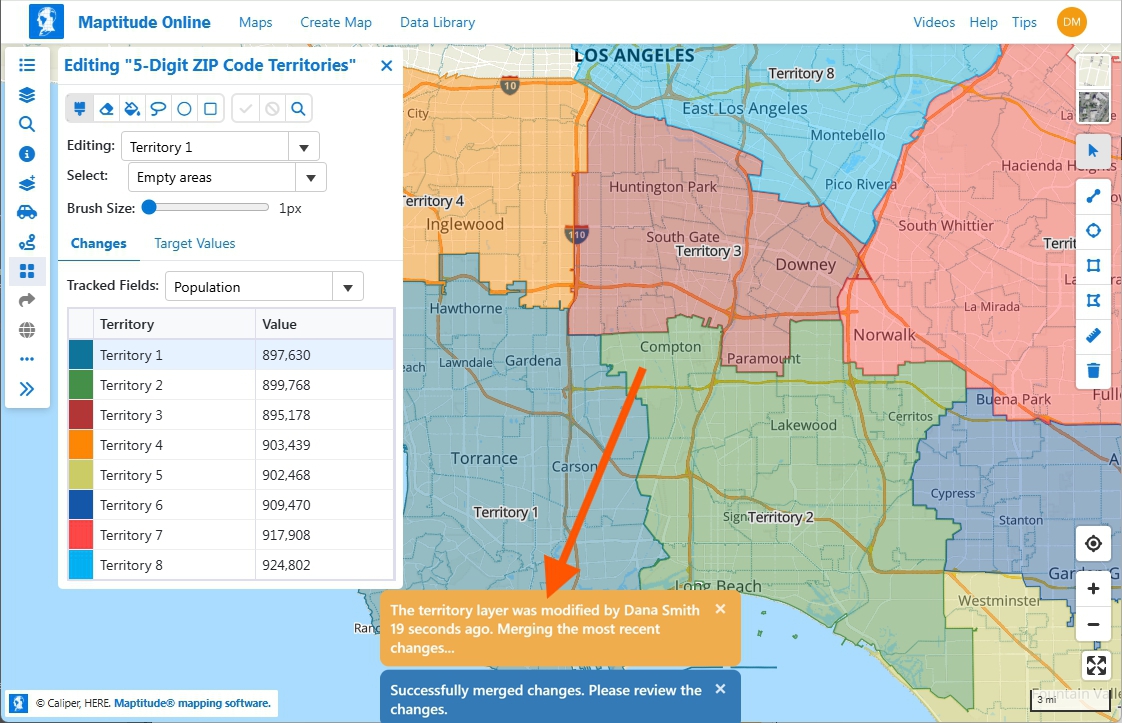
Multiple users edit the same territory map simultaneously. Changes are merged automatically and confirmed with a notification to each collaborator.
Maptitude Online supports up to 100 stops per optimized route, with no limit on the number of routes created within the account. Route optimization is included in the subscription at no additional cost. There are no per-route charges or API fees.
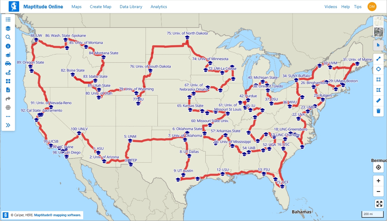
Maptitude Online optimizes a route with up to 100 stops. No per-route charges or API fees.
Drive-time analysis is included in every Maptitude Online subscription at no additional cost. There are no per-ring charges, no API fees, and no usage caps*. Maptitude Online supports drive-time rings up to 10 hours of travel time around 100 locations simultaneously. Drive-time rings can be renamed, layered, styled, and shared, and are available from the first day of the free trial. Maptitude Online calculates demographics for each individual concentric ring and lets you choose whether those are for the individual band (e.g., just the 0-2, 2-4, and 4–6 mile rings) or cumulative (everything within 6 miles).
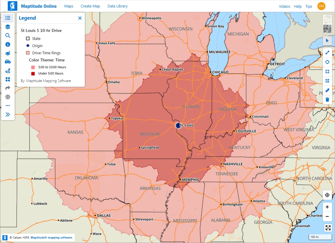
Maptitude Online generates drive-time rings up to 10 hours of travel time. Included in every subscription at no additional cost.
Maptitude Online runs on its own mapping infrastructure, hosted entirely on managed servers. Map tiles are generated and served from its own AWS environment. Rendering uses the private Maptitude Online branch of MapLibre GL JS, an open-source mapping library, combined with Maptitude mapping engines that are also hosted on AWS. Geocoding uses a combination of a proprietary Maptitude geocoding engine and self-hosted open-source geocoding software, with no dependency on commercial third-party geocoding APIs. This means location and customer data submitted for geocoding or mapping is processed within the Maptitude infrastructure and is not transmitted to third-party (commercial or otherwise) mapping or geocoding providers. Organizations with data privacy requirements, including healthcare, financial services, and government, can use Maptitude Online without their location data passing through external APIs.
Yes. Maptitude Online is designed, built, and maintained entirely by Caliper Corporation, a GIS software company with more than 40 years of experience. The mapping engine, geocoding, routing, drive-time analysis, demographic data, and territory tools are all native to the platform and not assembled from third-party APIs or external data services.
This has three practical consequences for organizations evaluating cloud mapping tools:
Yes. Maptitude Online includes enterprise-grade security features in every subscription at no additional cost:
Single Sign-On (contact for pricing): Maptitude Online supports your company’s SSO provider, such as Google Workspace, Okta, and Azure AD, including any two-factor authentication it requires.
There are none. The Maptitude Online 30-day free trial includes full, unrestricted access to every feature in the platform with no credit card required: geocoding, territory creation, drive-time analysis, demographic data, route optimization, and map sharing. Account storage, map loads, and all usage allowances are identical to a paid subscription. The trial begins immediately upon signup with no waiting period, no feature restrictions, and no obligation to purchase. At the end of 30 days, the account can be converted to a paid annual subscription at $795.
Google Sheets support (2026)
On-Map Messaging (2026)
Map Analytics (2026)
Salesforce Objects support (2026)
* Unlimited up to 20GB storage per account.
† All public and
private map loads count toward a combined 100,000 map loads per
month. If that figure is exceeded, shared maps continue to run
without interruption.
‡ Map access for inactive subscriptions or
in excess of monthly allowances is provided at Caliper Corporation's
discretion.
a For maximum responsiveness, cluster themes are recommended, especially for single layers that approach the maximum features per map (e.g., a single layer of 200,000 locations)

Home | Products | Contact | Secure Store
