Mapping Software and GIS Glossary
A ZIP Code is a five digit numeric code that identifies a collection of mailing addresses within the United States and its territories to simplify the distribution of mail by the United States Postal Service (USPS).
A ZIP Code is a delivery sort sequence and the USPS does not associate an area with each ZIP Code. Said another way, ZIP Codes are lists of addresses for delivering the mail. They are not areas. However, many ZIP Codes have delivery areas, and some ZIP Codes are for buildings or campuses that have defined borders. Boundaries can also be created by grouping small areas (defined by the U.S. Bureau of the Census for their nationwide street map) based on the dominant ZIP Code of the addresses in each small area, but this is an approximation because carrier routes may overlap and portions of the country have no deliverable addresses. The ZIP Code areas often do not adhere to boundaries of cities, towns, counties, or states.
Every ZIP Code can be shown as a point. The point is at the Post Office for the ZIP Code, if there is one, or at a central location normally inside the ZIP Code area (when the ZIP Code can be shown as an area). For some ZIP Code areas, the Post Office may be outside the ZIP Code area, typically because the Post Office serves multiple ZIP Codes.
A ZIP Code is a five-digit numeric code that identifies a collection of mailing addresses within the USA, to simplify the distribution of mail by the USPS. In general, a ZIP Code is a delivery sort sequence and the USPS does not associate an area with each ZIP Code.
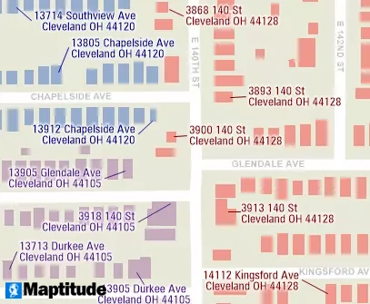
Addresses color-coded by the ZIP Code to which they belong
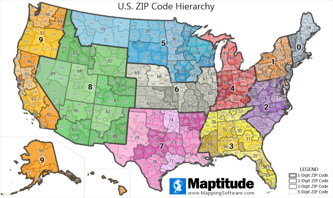
The 5-digit ZIP number is a structured code in which the first digit identifies one of ten large areas of the Nation. Groups of states (or equivalent areas) number from 0 in the Northeast to 9 in the West.
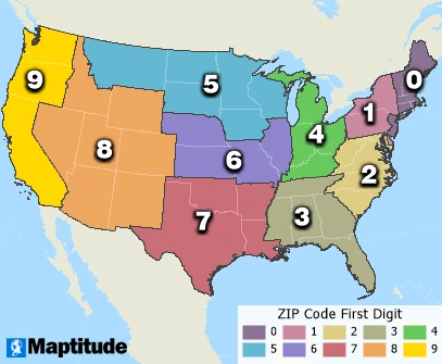
1-digit ZIP Code territories
The second digit of a 5-digit ZIP Code indicates a State, a geographic portion of a heavily populated State, or two or more less populated States.
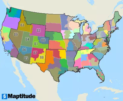
2-digit ZIP Code territories
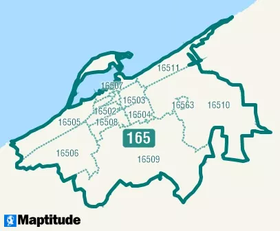
3-digit ZIP Codes are a collection of 5-digit ZIP Codes with the same first three digits. For example, the "165" 3-digit ZIP Code comprises all 5-digit ZIP Codes that begin with "165." They identify a major area within a State, which may be a large city post office or a major mail concentration point (Sectional Center) in a less populated area.
Some 3-digit ZIP Codes, and their associated 5-digit ZIP Codes, do not form contiguous areas. For example, 683 and 684 when merged together form a contiguous area. 683 contains all the 5-digit ZIP Codes whose "name" (often the associated town or neighborhood name) begins with the letter A-L, while 684 contains all the 5-digit ZIP Codes whose "name" begins with the letter M-Z. They are the ZIP Codes that surround Lincoln, Nebraska ZIP 685.
A 3-digit ZIP Code and all of the 5-digit ZIP Codes it encompasses
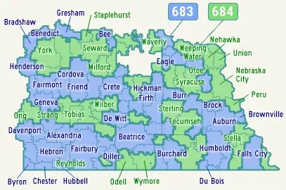
The 683 and 684 3-digit ZIP Codes together form a contiguous area
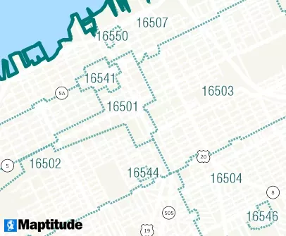
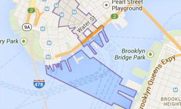
Many 5-digit ZIP Codes can be shown as areas. For example, those ZIP Codes that encompass multiple addresses, and ZIP Codes for buildings or campuses that have defined borders. The boundaries of the ZIP Code areas are created by, for example, grouping small areas (defined by the Census Bureau) based on the dominant ZIP Code of the addresses in each small area. Some can even be a single block, such as 16544.
Five-digit ZIP Code Tabulation Areas (ZCTAs) are based on Census blocks and are distinct from USPS-based postal areas. Maptitude 5-digit ZIP Code area layers are much more accurate than ZCTAs because they are based on Census areas that are smaller than a block. This greater detail allows Maptitude ZIP Code areas to better follow actual deliverable addresses. In addition, the Maptitude ZIP Code area layers extend into undeliverable areas to encompass the entire USA and are updated annually to account for USPS changes to ZIP Codes.
Approximate 5-digit ZIP Code area boundaries
Every ZIP Code can be shown as a point. The point is at the Post Office for the ZIP Code, if there is one, or at a central location inside the ZIP Code area where the ZIP Code can be shown as an area. ZIP Codes are also shown as points when they can't be shown as an area such as 5-digit ZIP Codes for a single business, building, or PO Box. For example, ZIP Codes 16522, 16530, 16534, 16538 and 16553.
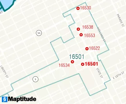
ZIP Codes that cannot be shown as areas can be displayed as points
A ZIP+4 code is an extension to the standard 5-digit ZIP code used by the USPS to further specify a location for mail delivery. It consists of the original 5-digit ZIP code followed by a hyphen and four additional digits. The additional digits help to identify a more specific geographic area, such as a specific house, block or group of addresses within the 5-digit ZIP code area. The ZIP+4 code is used to improve the accuracy and efficiency of mail sorting and delivery.
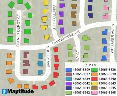
Addresses color-coded by the ZIP+4 to which they belong
ZIP+6 is an informal term for a ZIP+4 code plus two delivery point digits. The USPS calls this a Delivery Point Code. While ZIP+4 identifies a small area such as a city block or group of apartments, the delivery point digits narrow it down to a specific house, apartment, suite, or PO Box. The full 11-digit code is written as 12345-678901. These codes are used in automated mail sorting but are not typically used as geographic units for mapping purposes.
ZIP+6 Addresses on a city block
ZIP+7 is an informal term for a 12-digit code used in USPS barcode systems. The USPS calls this a Numeric Delivery Point Barcode. It consists of the ZIP+4 code, two delivery point digits, and one check digit (written as 12345-6789012). The check digit verifies that the barcode was scanned correctly. This code is used exclusively for automated mail processing and is not a geographic unit that can be mapped.
The USPS divides each ZIP Code into carrier routes. A USPS carrier route is a grouping of addresses that are near each other. Each carrier route is identified by a unique code that consists of the original 5-digit ZIP code followed by a letter and 3 numbers. The letters are H for Contract, R for Rural, and C for City. Each carrier route includes a list of addresses that the carrier is responsible for delivering mail to. This allows for more efficient and organized mail delivery within a given area. As for 5-digit ZIP Codes, they are not defined as areas by the USPS, but a central point for each such list of addresses can be displayed on a map.
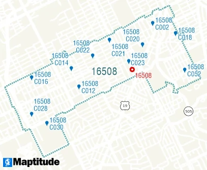
Carrier route centroids within a ZIP Code
A USPS Post Office (PO) Box is a secure and convenient way to receive mail when a physical address is not available or preferred. These are mapped as 5-digit ZIP Code points and are often located with many other such points at a specific Post Office location.
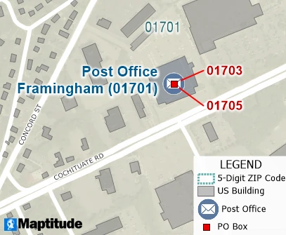
PO Box ZIP Codes located within a ZIP Code's central post office
Though the ZIP Code areas are approximations, Maptitude Mapping Software includes the most accurate ZIP Codes on the market. Included with Maptitude, and available for use in other applications, are:
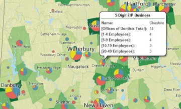
Maptitude gives you all of the tools, maps, and data you need to analyze and understand how geography affects you and your business. With Maptitude you can locate unlimited records by ZIP Code, map your data aggregated by ZIP Code, build sales territory maps from ZIP Codes, and analyze Census demographic data by ZIP Code.
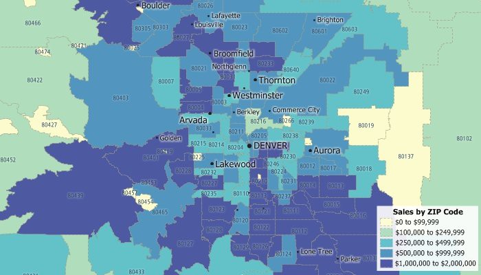
Maptitude will aggregate your sales data by ZIP Code so you can better understand the geographic component of your data
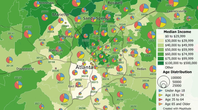
The Maptitude U.S. Country Package includes extensive demographic data at the ZIP Code level
Get access to ZIP Code territory tools, ZIP Code heat maps, and many more advanced features by signing up for a free trial today!
Embed this map on your site:
Home | Products | Contact | Secure Store
