

Author:
Stewart Berry
Images: Dan Martin
The pandemic has altered the business landscape in many ways, not least through relocations and closures. The full impact of the epidemic on companies is not yet known. We can better analyze the influence of the "how" and "where" of business, demographic, and economic change by looking at pre-pandemic business establishment and employment patterns and characteristics by ZIP Code. The impact on companies will vary in severity and duration depending on location and business type. A more comprehensive picture of the fallout will become more measurable in the months ahead, and this is a first step in that analysis.
The updated ZIP Code Business Count data for Maptitude 2021 includes the total number of businesses by type (by 6-digit North American Industry Classification System or "NAICS" codes, formerly known as SIC codes). For each business type (e.g., Full-Service Restaurants) you can map the number that fall into each employment size category (e.g., Full-Service Restaurants with 1-4 employees, Full-Service Restaurants with 1000+ employees, etc.).
These data are useful for businesses and market research analysts because they allow for analyzing market potential, measuring the effectiveness of sales and advertising programs, setting sales quotas, and developing budgets. Government agencies use the data for administration and planning.
The ZIP Code Business Count data are free for current Maptitude users, and is also available as shapefile, KML, KMZ, or GeoJSON for a fee.
"ZIP Code Business Patterns" (ZBP) is part of the "County Business Patterns" (CBP) product released annually by the U.S. Census Bureau. It provides annual data on the total number of establishments, employment, and payroll for over 40,000 5-digit ZIP code areas nationwide, plus the number of establishments (in nine employment-size categories) by detailed industry.
The data are useful for studying the economic activity of small areas; analyzing economic changes over time; and as a benchmark for statistical series, surveys, and databases between economic censuses.
The data set excludes data on self-employed individuals, employees of private households, railroad employees, agricultural production employees, and most government employees.
The Maptitude ZIP Code layer contains data derived from the currently released County Business Patterns, which normally provides counts from 2 years ago. It includes the total number of establishments for each business type using the 6-digit NAICS. Also provided are nine fields for each business type showing the number of establishments based on the number of employees. The ZIP Code Business Count map layer can be added to any Maptitude map.
Precautions are taken to avoid disclosing the operations of an individual employer (see How Accurate is the Census Data, below).
The business data are provided by ZIP Code, but what is a ZIP Code? We can Google for an explanation and will be shown ZIP Code matches and lookups in the Knowledge Graph section of Google search results. For example, if you search for Boston, MA ZIP Codes in Google, you will be presented with all the ZIP Codes in that city. If you then click on a ZIP Code, Google outlines the area of the ZIP Code within the map on the right side of the search results page.
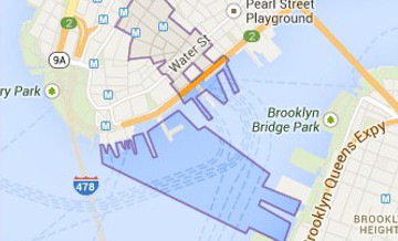
However, whenever we explore a few of these Google defined ZIP Codes we find discrepancies with other datasets. For example, in Mattapan in Boston the Google ZIP Code "02126" extends southwest past Greenfield Road. When compared with the same ZIP Code in the Maptitude mapping software, Zillow Neighborhood Boundaries, and the USPS ZIP Code finder tool, the difference is striking. None of these other sources have this ZIP Code bulge out to encompass addresses such as 22 Taunton Ave. The ZIP Code "02126" is highlighted in these two maps:
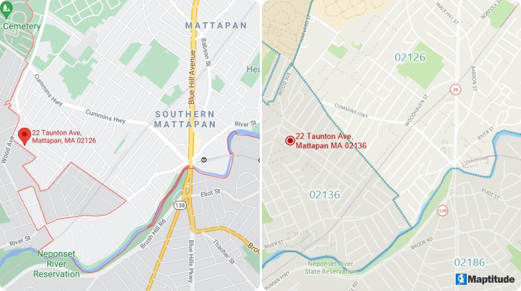
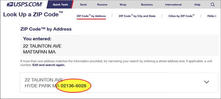
The Google map (top left) shows ZIP Code 02126 extending southwest whereas the Maptitude map (top right) and Zillow Neighborhoods show the correct boundaries. A USPS ZIP Code search for the address shows that the correct ZIP Code is 02136 (bottom).
What could have caused such an egregious error by Google, you ask? Well, the answer is not as straightforward as one might imagine and touches on important characteristics of ZIP Code areas that most people, including marketers, overlook or don’t understand. Such misunderstandings can impact comparisons of marketing data or sales territory definitions.
A ZIP Code is a five-digit numeric code that identifies a collection of mailing addresses within the United States, to simplify the distribution of mail by the United States Postal Service (USPS). Every ZIP Code can be shown as a point on a map. The point is located at the address of the post office for the ZIP Code or, if the ZIP Code can be shown as an area, at a central location inside the ZIP Code area.
Why the "if"? Only some ZIP Codes can be shown as areas. Many ZIP Codes do have delivery areas, and some ZIP Codes are for buildings or campuses that have defined borders. However, ZIP Codes are usually a list of addresses for delivering the mail. They are not, by definition, areas but are the street-based routes the mail carrier travels to deliver the mail to us. Boundaries can be created based on the location of addresses, but this is an approximation because carrier routes may overlap, and portions of the country have no deliverable addresses. To compound the difficulties in creating these areas, the ZIP Codes often do not adhere to the boundaries of cities, towns, counties, or states.
Consequently, ZIP Code definitions vary by the organization creating them, as highlighted by the odd Google Maps ZIP Code data above. Using ZIP Codes from different sources, even of the same vintage, can therefore have real world impacts, such as confusion over business counts. There are even once a decade ZIP Code approximations published by the Census Bureau called ZIP Code Tabulation Areas (ZCTAs), which are used for publishing decennial and ACS census data.
The Maptitude Team strives to create the best possible ZIP Code boundaries available. You can be confident in their accuracy and in the business decisions you make when using them. Maptitude includes current and projected demographics, and maps for 5-Digit and 3-Digit ZIP Code boundaries plus the 5-Digit ZIP Code points.
The U.S. Census Bureau’s County and ZIP Code Business Patterns (CBP and ZBP) datasets are generated annually from the Business Register, a large administrative database updated by several federal agencies which contains every business establishment in the U.S. with paid employees. Business establishments are defined as single physical locations where business is conducted or where services or industrial operations are performed. Establishments are assigned to industries, which are groups of businesses that produce similar products or provide similar services, using the NAICS. The ZBP contains tables with total establishments, employment, and wages by ZIP and counts of business establishments by NAICS and ZIP. The CBP has these tables plus a few others for counties.
Prior to the release of the 2017 ZBP, the number of establishments was not considered sensitive information. Therefore, counts of establishments were released without any disclosure avoidance methods applied (i.e., the data were not fudged to protect privacy). Now, however, areas with fewer than 3 establishments have been omitted.
So, what does this mean? First, for any county or ZIP Code that has fewer than 3 business establishments in total, records for that county or ZIP Code will not appear in the dataset at all (although establishments in these areas will be counted in summaries of larger areas, like states or metro areas).
Second, for a given geographic area, if a given NAICS category has less than three business establishments, the number of establishments won’t be reported for that category, but they will be included in the sum total.
Each year, the Maptitude Team releases detailed industry data from the ZIP Code Business Patterns. This allows you to add more data to your Maptitude reports and maps. The Census Bureau developed the ZBP as an annual series to provide economic data by industry. These data include the number of establishments, employment, first quarter payroll, and annual payroll. Much of the data are organized by the NAICS, standardized codes used by the federal government to track and analyze industry and establishments.
NAICS is a 2- through 6-digit hierarchical classification system, offering five levels of detail. Each digit in the code is part of a series of progressively narrower categories, and the more digits in the code signify greater classification detail. The first two digits designate the economic sector, the third digit designates the subsector, the fourth digit designates the industry group, the fifth digit designates the NAICS industry, and the sixth digit designates the national industry. The 5-digit NAICS code is the level at which there is comparability in code and definitions for most of the NAICS sectors across the three countries participating in NAICS (the United States, Canada, and Mexico). The 6-digit level allows for the United States, Canada, and Mexico each to have country-specific detail. A complete and valid NAICS code contains six digits.
Maptitude ships with a ZIP Code layer that contains business count data. This layer includes the total number of businesses by type by 6-digit NAICS codes. Detailed breakdowns by industry can also be downloaded.
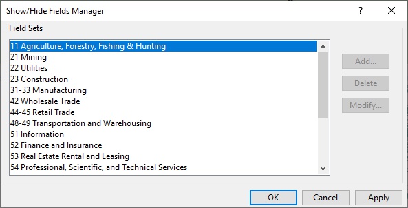
Often, the only data relevant to your organization may be those within a specific two-digit NAICS sector. You can choose to limit dataviews to show just the data in a specific sector using the predefined Field Sets that are provided in Maptitude.
Another common use case of the data involves making a color or “heat” theme based on the number of businesses of some type within a given area. This map shows the total number of logging businesses in each state:
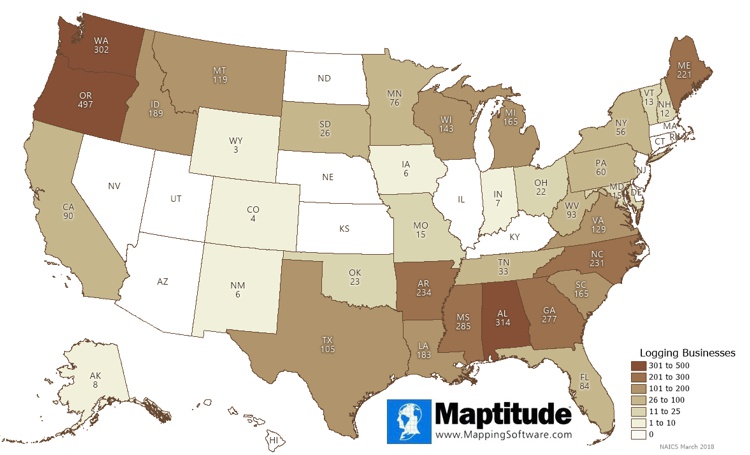
Most of the 4211 logging businesses can be found in the Northwest and Southeast United States, along with the upper Midwest and Maine. The greatest number of businesses are in Oregon (497), followed by Alabama (314), Washington (302), Mississippi (285), and Georgia (277).
The number of logging businesses is just one of the business count fields available for Maptitude. Maptitude users can download a free ZIP Code layer that has business counts for 978 NAICS codes including logging, timber tract operations, mining, and more.
Maptitude lowers the burden required for a successful business mapping analysis, project, or report. By integrating with key geographic, demographic, and housing datasets, Maptitude provides a one-stop wizard-driven interface. Maps are an intuitive way to convey and analyze large amounts of data. Maptitude can support all the above analytics and can access all the data used in the examples shown, as well as information for almost any industry and sector you would need to map.
Learn more about Maptitude to see how you and your team can access the data critical to making successful real estate decisions!
Schedule a Free Personalized Demo
Home | Products | Contact | Secure Store
