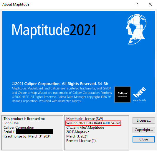
As we improve the Maptitude software, new “builds” of the software are released with incremental improvements. You can see which build of the software you are using by going to Help>About… from the main toolbar.
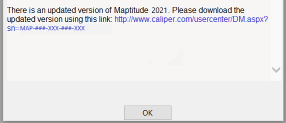
If you have Maptitude 2021, you can get the latest version of Maptitude 2021 by going to Help>Check for Updates and clicking on the link:
Below are the release notes for the different builds of Maptitude:
| Build # | Ship Date | Release Notes |
| 4900 | 3/4/2021 | Main Release |
| 4905 | 3/15/2021 | More color ramps supported in the Multiple Fields theme |
| Improved handling for OpenStreetMap (OSM) files | ||
| Added new text in the Create-a-Map Wizard explaining the geocoding steps | ||
| Improved speed when working with a large number of maps | ||
| Select by Condition interface improved | ||
| Multiple text items can now be rotated together | ||
| 4910 | 3/29/2021 | Buffer sizes can now be built to a custom formula value |
| Improved handling of depot assignments using the Vehicle Routing and Pickups tool | ||
| Improved handling of GeoJSONs with Maptitude Online | ||
| Increased allowed number of seeds in the balanced territory tool | ||
| 4915 | 4/29/2021 | Multiple Field Color Themes now allow joined fields |
| Map annotations are now copied when duplicating maps | ||
| Improved handling of manual theme intervals | ||
| Improved locating of linked records files | ||
| Standardized terminology when using the Vehicle Routing and Pickups tool | ||
| Numerous changes to Python installation | ||
| Balanced Territories now allow joined fields | ||
| Various icon related changes | ||
| Improved logging in Maptitude Online | ||
| 4920 | 6/7/2021 | Various improvements and fixes to the Vehicle Routing and Pickups tool |
| Facility Location tool now allows existing facilities to be candidate facilities | ||
| Layers with feature display can be more easily modified with the display manager | ||
| Increased upload size for Maptitude Online to seven layers | ||
| Improved Canadian geocoding | ||
| 4925 | 6/8/2021 | Improved routing calculation speed |
| Advanced Selection options have been expanded to points | ||
| Clarified labeling for Longitude/Latitude geocoding | ||
| 4930 | 6/25/2021 | Several routing fixes and improvements |
| 4935 | 7/22/2021 | Added ability to skip night break in routing |
| Various improvements to the Map Properties dialog box | ||
| Added enhancements for the localized language | ||
| 4940 | 8/9/2021 | Added information for the Display Manager when closed |
| Improvements to the routing API | ||
| 4950 | 8/21/2021 | Improved path finding with the routing manager |
| Loading color theme setting now automatically updates the map | ||
| 4970 | 1/4/2022 | Various improvements to the Manual Theme |
| Features can now be tagged with their distance to the edge of an area | ||
| Travel time default output changed from matrices to tables | ||
| After geocoding using the CaMW, the set of any unlocated records now automatically opens in the display manager | ||
| Improvements to Mask handling of icons and labels | ||
| Various improvements to the Plurality Theme | ||
| Restored and made fixes to non-english characters, translation and string handling | ||
| Percent field formats are now preserved in reports | ||
| Routing reports now show Custom fields in the first column | ||
| 4975 | 1/27/2022 | Various non-english translation changes |
| Reintroduced a Land Use add in and corresponding tutorial file | ||
| Improved tagging points by nearest area boundary | ||
| Fixed an issue with the speed adjustment slider in drive-time rings |