Why Won’t My Shared Online Map Load Correctly?
If a shared Maptitude Online map does not load correctly, your browser or organization’s network may be blocking access to one of the domains required to display the map. This can cause some map layers, labels, colors, or detailed geography such as states, counties, ZIP Codes, or census tracts to appear incorrectly or not appear …
How do I embed a Map in a Tableau dashboard?
Embedding a Maptitude Online map in Tableau™ is a simple way to combine interactive Maptitude Online web maps with Tableau dashboards and charts. This step-by-step guide explains how to publish a map in Maptitude Online, add it to a Tableau dashboard using Tableau’s Web Page object, and then publish the finished dashboard for others to …
How to Create a Heat Map with Territories?
You can create heat maps in Maptitude mapping software using custom territory layers to visualize data grouped by sales regions, service areas, or other user-defined boundaries. While heat maps are often created using standard geographies such as ZIP Codes or census areas, Maptitude also allows you to generate heat map-style thematic maps directly from territory …
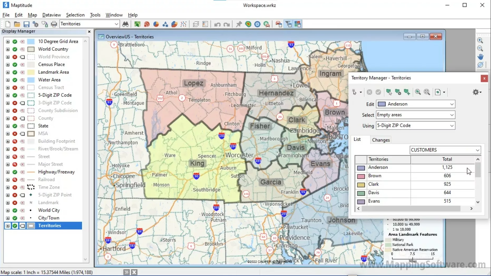
How Do I Select and Display Single Territories?
You can create, select, and display specific territories using mapping software. In Maptitude, you can create any number of territories interactively and also from a territory spreadsheet. To select and display specific territories, you can follow these steps: Make sure your selection toolbar is visible. If it is not, toggle it on by going to …
How to Exclude Links from Routes
You can exclude links from your routes using route mapping software. Users can enable or disable specific sets of links, including ferry routes, when calculating routes in Maptitude. This article covers how the new Enable/Disable Links feature works and how it improves routing flexibility. This is especially helpful when planning routes for vehicles that should …
How Do I Compile and Run GISDK Scripts?
GISDK scripting allows users to automate geoprocessing tasks. Users need to compile their GISDK scripts before execution. This article explains how to change a .txt file into a .rsc file. Changing File Extensions for GISDK Scripts To compile and run a GISDK script, you need a .rsc file. If you have saved your script as …
How Can I Locate Republic of Ireland Postcodes (Eircodes)?
You can map Eircodes using services available in mapping software. You can try these methods below by requesting a free trial of Maptitude mapping software or using your own license. Table of Contents What are Eircodes? Locating Addresses and Eircodes with Country Packages Using Web Services to Locate Eircodes What are Eircodes? Eircodes are the unique postal codes …
How Can I Locate Republic of Ireland Postcodes (Eircodes)? Read More »
How to Perform Spatial Segmentation Analysis?
Understanding your customers is essential for growth, and one of the most powerful tools for doing this is business GIS. With tools like Maptitude, organizations can move beyond simple lists of customers or ZIP Code maps to uncover patterns, trends, and opportunities that are otherwise hidden in spreadsheets. Using geodemographic segmentation data alongside your customer …
How to Identify Target Zones for Expansion
To identify target zones for expansion, you can use market targeting mapping software. Market targeting is a strategy used by businesses that have a deep understanding of their customer base. This approach relies on identifying customer traits and linking them to data sets for actionable insights. For example: An established restaurant may know its core demographic …
How Do I Optimize a Route in Python?
To optimize a route in Python, you can use the Maptitude GISDK. This example can be run outside of Maptitude, even with the Maptitude application being closed. It can be run from within Visual Studio Code, for example. Table of Contents 1. Download and Install Software 2. Create a Python file 3. Run the Python …
How Do I Mark My Own Map?
You can mark your own map using map marking software. To draw marks on a map using Maptitude, follow these steps: Download and install a free trial of Maptitude mapping software, or use your own license of desktop Maptitude. Choose an editable point layer from the drop-down list on the Standard toolbar or create a new point …
How Do I Map Hurricanes?
You can import, map, and analyze The National Hurricane Center’s (NHC) GIS weather data using mapping software. The NHC provides vital GIS (Geographic Information System) data that is essential for tracking storms, hurricanes, and other severe weather events. For professionals and enthusiasts alike, leveraging this data in Maptitude, a leading GIS software platform, can unlock …
How to Link Information to Features on a Map
You can link information to features on a map using mapping software. Maptitude lets you link all types of information to features on a map. You can link map features to documents, programs, or sites on the Internet. This tutorial will guide you through the steps to phone your customers using Skype by simply clicking on them …
How Can I Convert DMS to Decimal Degrees?
You can convert DMS Latitude and Longitude fields into Decimal Degrees using Excel. You can then map the coordinates with Maptitude mapping software. When you enter coordinates in Maptitude, you may find that your data is in Degrees-Minutes-Seconds (DMS) format, which needs to be converted to decimal degrees for most mapping tasks. This article details the …
How Do I Build Radius Rings That Contain the Target Value?
You can create radius rings or buffers that contain a target value using Maptitude geographic analysis mapping software. Step-by-step tutorial on creating build to value radius areas.
How Do I Use Free Add-on Layers in My Online Maps?
You can upload the free map data add-ons or third party geographic data to your online maps using Maptitude online mapping software. Step-by-step tutorial on sharing layers to online maps.
What Makes a Good Franchise Location?
You can determine a good location for your franchise using Maptitude franchise mapping software. Step-by-step tutorial on using the facility location analysis to find the best franchise location(s).
How Do I Create Balanced Territories for My Stores?
You can create balanced territories for your stores using Maptitude sales territory mapping software. Step-by-step tutorial on creating balanced store territories.
How Can I Find the Best Intersection for My New Site Location?
You can use Maptitude business mapping software to identify the best intersections for your new site location. Step-by-step instructions on analyzing the best intersection for your location.
How Can I Create Reports With Mapping Software?
You can create demographic reports, layout reports, and automated layout reports for areas with Maptitude.
How Can I Create Simple Territories for Each of My Locations?
You can create simple territories for each of your locations with Maptitude mapping software. Step-by-step instructions on how to create simple territories for locations.
How Do I See the Size of Areas Such as Building Footprints?
You can view the size of areas such as building footprints using GIS or mapping software like Maptitude. Step by step instruction to show the area of a building on a map in square feet or square meters.
How do I Create a Sales Territory Hierarchy Map?
You create a sales territory hierarchy map using sales territory mapping software such as Maptitude. Step by step instructions to create a sales territory hierarchy map. A territory hierarchy allows your organization to manage multiple territories.
How Do I Change Label Styles for Specific Features and Show a Theme?
You can change label styles in your demographic thematic map with Maptitude demographic mapping software. Step-by-step guide to show thematic maps at the same time as labels for only your areas of interest.
How Do I Choose the Fields Shown in the Info Tool?
You can select the fields shown in your map using data mapping software. Step-by-step guide on filtering the fields in the Info Tool.
How Do I Map Housing Market Data?
You can map housing market data using Maptitude real estate mapping software. A discussion of the types of housing data available and some of the ways with which you can map this data with Maptitude. Includes further information regarding concepts such as construction valuation and Housing Price Index.
How can I see the number of building permits by area?
An analysis of the rising costs of the housing market using census building permit data and how you can map this data yourself.
What Is the Housing Price Index and How Can I Map It?
You can map the Housing Price Index with Maptitude real estate mapping software. Create a map showing the Housing Price Index with a color theme.
What is Construction Valuation and how can I map it?
You can map Construction Valuation using Maptitude real estate mapping software. Example color map of Construction Valuation for 2019-2021.
How do I make my map legend look good?
How to make your map legends clear and easy to read using GIS software
How do I make my map labels look good?
How to make map labels visually appealing and easy to read using GIS software
How can I map my largest values?
How to map largest values with a plurality theme (multiple color theme) using GIS software
How do I make map themes look good?
A discussion of best practices for making thematic maps look good and convey data clearly using GIS software
How do I use Transparency in a Map?
An explanation of why and how to use transparency in your maps to reduce visual clutter and make your data easier to read
Open .an1 files in Maptitude
How to open an .an1 file in Maptitude using the File>Open and setting the file type to GPS Data.
How can I search for businesses using NAICS codes?
How to search for businesses using NAICS codes and to change the Caliper ZIP code Business Count data to use these codes
How do I find locations in the overlap between rings?
How to identify locations that fall in the overlap between two areas using buffers, drive-time rings, or any other area layers
How Do I Automatically Create Territories of Equal Size?
You can automatically create territories of equal size with Maptitude sales territory mapping software. Step-by-step tutorial on balancing territories.
What can I do if my points overlap?
If you have multiple records with the same address, or if they have located by postal code or City, then the points that represent these locations will overlap. There are several strategies that could be used to help differentiate these locations. Below are some recommendations to address this. Users can try these to see what …
How do I automatically map my data using the locate tools?
Maptitude has a Locate Wizard that will automatically map your locations and apply the next best level of accuracy for un-found locations. You can control exactly which locate methods you want to apply and once your records are located, Maptitude reports the method used to place each pushpin. The following article will outline how to …
How do I automatically map my data using the locate tools? Read More »
Counts of locations by regular grid cells
How to get counts of locations by regular grid cells
Create custom fields such as “Millennials” using Sum Fields
How to create custom fields such as “Millennials” using Sum Fields
Identifying high growth areas
How to identify high growth areas
Using Formula Fields to Create Percent fields for Themes
How to Create Percent fields for Themes using Formula Fields
Why Are My Maps Not Centered?
Why your Maptitude Maps may not be centered/straight and how to fix it
How Can I Find the Center or Centroid of an Area?
How to find the center of your areas
How Can I Upload My Maps to Maptitude Online?
How to upload maps to Maptitude Online
How do I map my Census Tract codes?
You can map Census Tract codes using Maptitude Census data mapping software. How to import and map your own Census tract codes.
How do I filter healthcare locations by taxonomy?
How to filter healthcare locations by taxonomy
How do I create a ring that encompasses healthcare providers?
How to create buffers that cover healthcare providers
How Can I Aggregate the ZIP Code Business Count Data to Other Area Layers?
How To Aggregate the ZIP Code Business Count Data to Other Area Layers.
How do I create summary fields from the free USA demographic projections?
You can summarize the USA Country demographic projections with demographic mapping software. Step-by-step tutorial on creating summary fields from demographic projection.
How do I import opensource public transport/transit data?
How to import GTFS data with Maptitude.
How Can I Add an Image to My Map?
How to register an image to be placed on a map.
How do I use the Facility Location tool if I don’t have Candidate Facilities?
How to use the Facility Location tool in Maptitude when you do not have any Candidate Facilities to choose from
How can I split my list of stops into equal size clusters for routing?
How to use the Clustering Add-in for Maptitude to divide a layer of points into similarly sized groups that can then be routed individually
Why Can’t I Use The Export to PDF option?
How to reinstall Microsoft Print to PDF in Windows 10 so that you can use the Export to PDF option in Maptitude
Why isn’t my data being recognized as Latitude/Longitude Coordinates?
You can use Maptitude pin mapping software to configure your data as latitude/longitude coordinates. Troubleshooting to map coordinates.
When Can I Use the Edit-Undo Function in Maptitude?
When you can use the Edit-Undo function in Maptitude, and what to do when this option is not available
How can I create a customized version of the healthcare layers?
How to filter the healthcare data to just the locations you are interested in and then create your own layer from this filtered list
How do I find a central location for my layer?
You can find the central location for a set of locations or areas using Maptitude geographic analysis mapping software. Step-by-step tutorial on fidning the geographic center, mean center or weighted center for your layer.
How do I Calculate Multiple Point-to-Point Driving Drive Times at Once?
You can calculate driving times for multiple points using Maptitude route planning software. Step-by-step tutorial on Distance and Travel Time Tables.
How can I Apply a Custom Color Theme to other Layers?
How to create and save a color theme with custom icons, then reapply and edit the same theme
How do I use British National Grid Eastings and Northings in a Map?
You can use Maptitude mapping software to map using eastings and northings. Step-by-step tutorial on mapping with eastings and northings.
How can I make a Postcode Heat Map for the DACH Region?
How to attach data to the DACH Postal Area layer to use in a heat map
How can I change the format for my data so that it shows up in a label?
How to reformat the data in your layer so that it displays more clearly in your labels
How Can I Convert My Territories to a Different Geography Layer?
You can convert your territories to a different geography layer by using Maptitude sales territory mapping software. Step-by-step guide on converting your territories to a different geography layer.
How Can I Add a Regression Line to my Maptitude Chart?
How to customize your Maptitude Chart by adding a regression line for a Scatter Plot
How Can I Limit my Map to Only the Areas I Want to See?
How to refine the focus of your map by only showing the areas you are interested in
How do I customize the style for layers that are using Feature Display?
How to work with a layer that has Feature Display settings applied
How Can I Get my Lat/Long Coordinates in Other Formats?
How to convert the Coordinate fields in Maptitude into other formats
Free Maptitude Online Trial
Maptitude Online trial request form
How Do I Add Multiple Territory Layers to the Same Map?
How to add more than one territory layer to any given map
How Do I Use My Own Data in a Demographic Report?
You can use your own data in a demographic report using demographic software. Step-by-step guide on configuring reports to use your own data.
Which Aggregation Method Should I Choose?
When to use the Add or Average aggregation method
How do I Change the Default Fields in my Demographic Reports?
Change the fields used each time you run a demographic report
How do I Choose the Type of Workspace I am Saving?
How to switch between Compressed and Uncompressed Workspaces
How do I Make a Layer in my Compressed Workspace its Own File?
How to save a layer as its own file and then add it to a Compressed Workspace
How do I change the color of Density Grids?
How to customize the color scheme for Density Grids
How can I format my addresses to be used in Maptitude using Microsoft Excel?
Using the Text to Columns feature in Microsoft Excel to format addresses for use in Maptitude
How do I make the color theme more transparent?
How to make a color theme appear slightly transparent so you can see features underneath
How Can I Show Multiple Routes on the Same Map?
You can show multiple routes on the same map using Maptitude route mapping software. Step-by-step tutorial on showing multiple routes on the same map.
How to include more fields in the Excel route list when using the Directions Manager?
How to increase the information included in the Routing Directions Report
How to outline or highlight a city or municipality
How to highlight and export the City Boundaries/Municipalities for your area of interest
How do I create borders or outlines around my map symbols?
Adding outlines to your points in a Maptitude map
How can I set up my map to print at large scales?
You can print maps at large scales using Maptitude mapping software. Step-by-step tutorial on printing map layouts.
How Do I Change the Way My Territories Look?
You can customize the look of your territories using Maptitude sales territory mapping software. Step-by-step instructions on changing the style of territories.