How Do I Map School Districts?
You can map school districts using Maptitude school redistricting mapping software. Step-by-step tutorial on mapping school districts.
Maptitude Learning Portal articles tagged with Census
You can map school districts using Maptitude school redistricting mapping software. Step-by-step tutorial on mapping school districts.
You can determine a good location for your franchise using Maptitude franchise mapping software. Step-by-step tutorial on using the facility location analysis to find the best franchise location(s).
You can access FFIEC data for your mapping work using Maptitude banking compliance mapping software. Step-by-step tutorial to map FFIEC data using the tract layer in the demographic map librarian.
The 2021 Canada Census Data can be accessed using Maptitude demographic mapping software. Details about the Canada 2021 census data release.
A discussion of the USA ZIP codes and how they are defined by the US Postal Service and other organizations with regards to GIS mapping software.
Information about the release of the US 2020 census data and when it will be available for use in Maptitude
You can map Census Tract codes using Maptitude Census data mapping software. How to import and map your own Census tract codes.
How to get more information on the data sources for the Country Package data in Maptitude
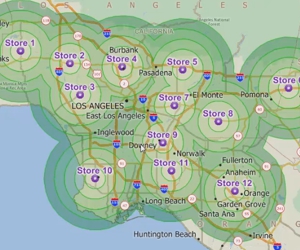
Using Maptitude to create rings based on the time it takes to travel over a street network from one or more origins