Last Updated: April 19, 2024
You can map school districts using school redistricting mapping software.
Mapping school districts is a crucial task in educational planning and administration, facilitating informed decision-making and resource allocation. One of the essential tools for this task is school redistricting mapping software, such as Maptitude, which offers robust features for creating, managing, and analyzing school district boundaries.
Educational institutions, real estate professionals, policymakers, and researchers rely on accurate school district maps for various purposes. In the real estate industry, understanding school district boundaries can significantly impact property values and market trends. For policymakers, mapping school districts is vital for effective territory management and demographic analysis, ensuring equitable distribution of resources and services.
To follow along with the steps below, you can request a free trial of Maptitude mapping software or use your own license of the application.
To begin mapping school districts using Maptitude, you can follow these steps below.
Table of Contents
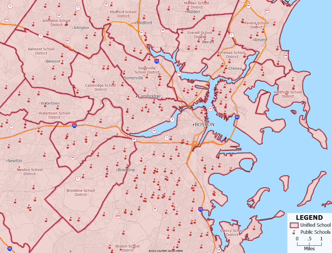
Display School District Boundaries and School Locations
Create and Manage School District Boundaries
Display School District Boundaries and School Locations
By adding school location data to your map, you can assess your location’s proximity to the nearest schools, or export the schools in a radius around a location.
With data for school district boundaries, you can provide additional context to your maps to fuel data-driven decision making.
You can try the steps below to utilize the school district boundaries and school locations in your maps.
- Download and install the School Districts and Schools product for Maptitude mapping software.
- From the Home Page, choose the New map of United States and click OK.
- Optionally, you can choose to zoom to a specific area on the map. Then, click Finish.
- Go to Map>Layers>Add Layer and browse to where you installed the School Districts and Schools data. By default, this will be in the C:\ccdata\ folder.
- In the School data folder, you can choose the layers that you want to add to your map. When finished, click Open.
- Click Close to return to the map. The data layers you chose should now be displayed on the map.
After adding the school districts and school locations to your map, you can use the geographic analysis tools in Maptitude to leverage the data and gain insight that is relevant to your mapping work.
If you want to export the school locations in a certain radius around a certain location, you can try the tutorial article on exporting points contained in a certain area in Maptitude.
If you want to create filters and sets of certain school locations, you can try the tutorial video on creating selection sets in Maptitude.
If you want to visualize the demographic information at the school district-level, you can try the tutorial video on creating thematic maps in Maptitude.
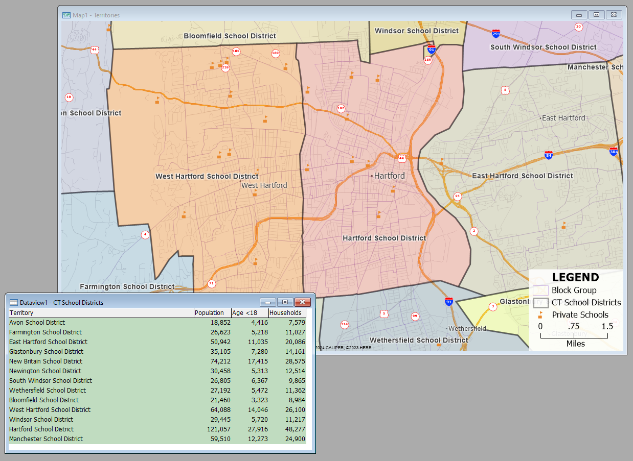
Create and Manage School District Boundaries
The territory tools and demographic data included with Maptitude mapping software can help you create school district boundaries.
You can try the steps below to use the tools and data in Maptitude to create your own school district boundaries.
- From the Home Page, choose the New map of United States and click OK.
- Optionally, you can choose to zoom to a specific area on the map. Then, click Finish.
- If you are planning on using Census Blocks or Census Block Groups to create your school districts, you can download and install the Census Block data or Census Block Group data.
Then, add the data to the map by going to Map>Layers>Add Layer and browse to the C:\ccdata\ folder. - Go to Map>New Territory Layer.
- Follow the tutorial video on creating territories in Maptitude to create your school districts layer. Make sure to change the Geography Layer to the level of geography that you are utilizing to create your school districts.
- Follow the tutorial video on working with territories in Maptitude to edit and manage your school districts.
- You can follow the tutorial article on tracking demographic data or your own data by utilizing tracking fields for your school districts.
- Export your school districts to an Excel file by clicking the Export to Excel button. If you’ve already mapped locations (such as schools, students, or employees), the Excel export will also include the locations contained in each district.
By leveraging mapping software like Maptitude, stakeholders in education and related fields can streamline processes, enhance planning accuracy, and ultimately contribute to better-informed decisions and improved outcomes within school districts.