Last Updated: March 5, 2025
You can use United Kingdom mapping software to map using British National Grid eastings and northings.
Eastings and Northings is a name of several kinds of co-ordinate systems and so it can be hard to figure out which system you need to be working in when trying to map by them. The most commonly used version is the British National Grid Eastings and Northings which covers the majority of the UK. This article will discuss two ways that you can use these in your map:
- Mapping a set of Eastings and Northings from Excel
- Searching a map for a specific Easting and Northing
The idea in both cases to change the way that Maptitude interprets coordinates so that it reads the data as Eastings/Northings instead of degrees of Latitude/Longitude.
To create a pushpin map from a list of Easting/Northing pairs:
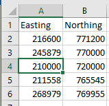
If you have a list of Easting/Northing pairs in Excel or another table format, you can make a pushpin map from them similarly to how you make a map of postcodes, addresses or Latitude/Longitude coordinates:
- Download a free mapping software trial of Maptitude Desktop or use your existing Maptitude Desktop license.
- From the Home Window, choose New map of my data/table/spreadsheet. Click OK.
- Browse for the file containing your Easting/Northing pairs and open it. Click OK.
- Scroll down to the bottom of the Matching fields. Next to X choose the field that contains your Eastings and next to Y choose the fields that contains your Northings. Click Next>
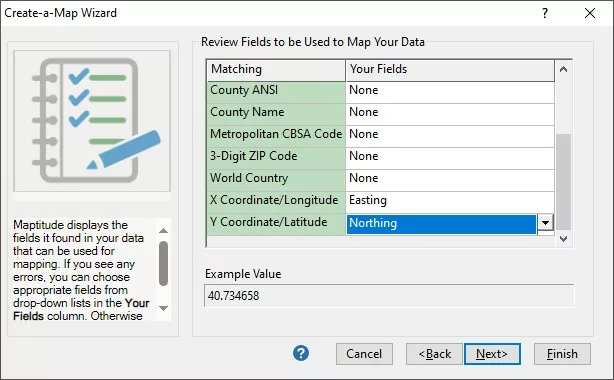
How do I use British National Grid Eastings and Northings in a Map? Review Fields Settings.
- Make sure Locate records in your file by coordinates is highlighted and click Coordinates…
- Under Coodinate System, set Class to Europe and set Zone to Great Britain: British National Grid
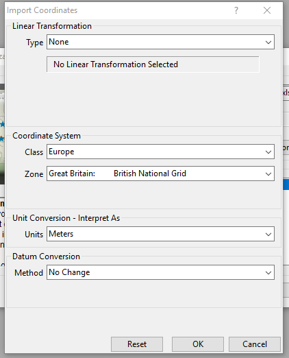
How do I use British National Grid Eastings and Northings in a Map? Coordinates Settings. Note: In some instances you may need to change the datum.
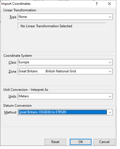
How do I use British National Grid Eastings and Northings in a Map? Datum Settings. - Click Click Finish. Click OK.
Maptitude will make a pushpin map out of the coordinate data you gave it. You can now do any of the same analyses as you could had you imported by Latitude/Longitude or by Address.
To search for a specific Easting/Northing location on a map
Note: Most people using British National Grid Eastings and Northings will do so based on the OSGB36 datum. However, the map layers shipped with Maptitude are based on the ETRS89 datum because the map layers need to be consistent with European and global geography. This means that the map features shipped with Maptitude will be offset by short distances from the expected locations because of this difference in datum.
If you have a map of the UK open, you can use the find tool to search for a specific location. If you tell the software that you want to work in Eastings/Northings first, you can search for an Easting/Northing location:
- Open a map of the UK
- Right-click on the map and choose Properties
- Uncheck Auto Projections and click Change Projection
- Under the Coodinate System tab, set Class to Europe and set Zone to Great Britain: British National Grid.
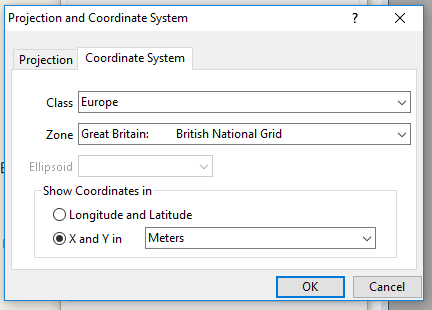
How do I use British National Grid Eastings and Northings in a Map? Projection Settings.
Click OK and OK - Go to Edit>Find or click in the main toolbar.
- Highlight coordinate in the scroll-list and check Use Local XY
- In X enter your Easting and in Y enter your Northing
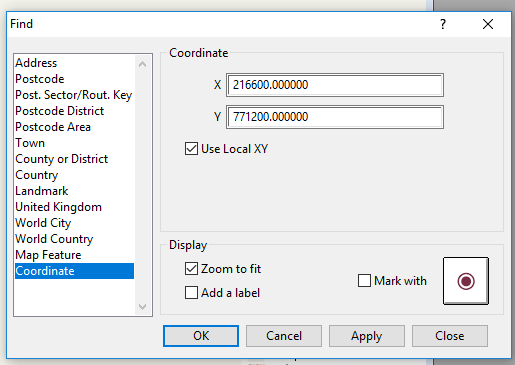
How do I use British National Grid Eastings and Northings in a Map? Find Coordinates. - Click OK and the map will zoom to where you entered. In the above example I zoom to the summit of Ben Nevis.
Repeat Steps 5-8 to search for other locations.