

Author:
Stewart Berry
Images: Dan Martin

A mapping application is often used to support a business analysis to answer questions such as: Where are my customers? Where are my competitors? Where are my prospects? However, no matter how powerful or useful a location intelligence tool is, without data it is useless. We aren’t talking about the data you already have and want to map. We are talking about the fundamental datasets that support successful mapping and problem solving. Surprisingly few map tools provide this data.
Read on for our list of the best geographic information system (GIS) and mapping data sources!
While many mapping systems provide little to no integrated data, Maptitude includes a wealth of information for free, and allows you to map your own data at no charge and without additional fees for credits or API access.
We will break down the key geospatial datasets into four types:
So, what data do we consider to be fundamental for a mapping system? For Maptitude, these datasets are those that allow the majority of our users to accomplish the majority of the tasks they need to complete. Every Maptitude map has streets, postal boundaries, landmarks, government and census boundaries, natural features, aerial imagery, and choice of map background.
You can then use your own data to:
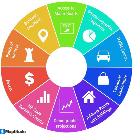
In addition to standard mapping requirements, each industry has unique and differentiated needs when taking a deeper dive into data. Healthcare analysis requires identification of providers by taxonomy code, franchises need to be able to define territory boundaries based on geodemographics at the local level, businesses target other organizations based on NAICS codes or consumers based on expenditure, direct mailers require address level pinpoints, while real estate site evaluation necessitates exploring traffic counts and access to major arterials and amenities as well as to competitors. Maptitude provides an a la carte menu for all these addon databases.
For the less commonly used and more niche datasets it is common for them to be priced according to their value and complexity. Such datasets often include congressional and legislative districts, school boundaries, Census blocks, and map packages for other countries.
We take a deeper dive into each of these 4 categories below.
The unparalleled benefit of providing all the typical datasets most busines users would need, is that the application can be directly integrated with this information. This allows the complexity of large and varied datasets to be hidden from the user, providing a truly user-friendly experience.
Tasks ranging from placing locations on a map, navigating a map, finding data, and visualizing information can be accessed through step-by-step Wizard interfaces.
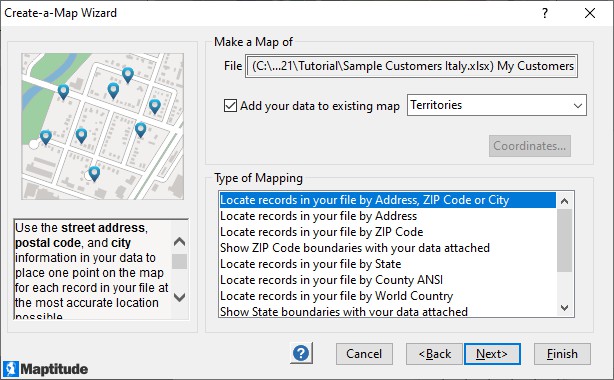
These Wizards can then be extended to make otherwise complex processes a breeze for even novice users. For example, automated territory creation, operations and logistics tasks such as multiple vehicle fleet routing or facility location, and clustering of customers, can each be a prompted, help supported, series of “Next” buttons and windows.

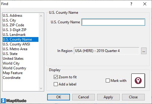
Even something as simple as a Find tool, a feature most users expect in productivity and analytics applications, requires a wealth of data to be able to provide accurate and comprehensive results when implemented in a mapping application.
And once you have zoomed to a location, visual contextual information is key, enabling you to orient yourself to the market area, while allowing your audience to be able to relate to what they are seeing in your presentation. This requires access to both imagery and map backgrounds that can be switched with the click of a button.
A mapping system should allow you to access your maps for free and to have options that do not require credits or additional charges to perform an analysis. Even with subscriptions, you will often have to pay more for storage of data, data access, and even map operations such as finding, zooming, and downloading reports. Plus, if your subscription ends, can you access your maps offline? Maptitude allows you to work with your business critical data offline or online, with unlimited geocoding (pin-mapping) and map operations, and has options for one-time purchases as well as subscriptions, allowing you to choose the model that best meets your needs.
You also shouldn’t expect to have to pay for plugins that enable access to geographic datasets. The number of mapping formats is dizzying and you will need a product that bakes in support for pretty much any mapping data you will encounter, from raster and vector to Shapefile and GeoJSON.
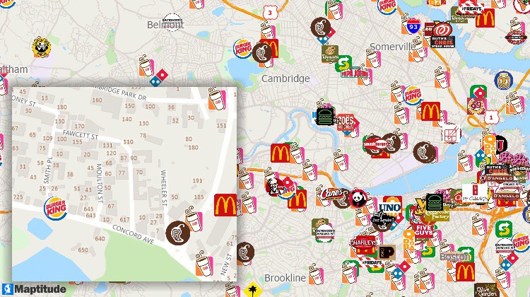
Accessing business and residential listings would seem like the first thing anyone would want to look at in a mapping system. However, they are not as common as you would think, and often carry a hefty price tag. Say you want to look at all the fast-food chains in your market, and the businesses and residences within 5 miles of a proposed site. How do you source all these data? And even if you do, are they presentation ready? Do they have company logos? Maptitude provides these locational data products and many more for free.
These additional datasets include easy to interpret traffic count data and the locations of highway on- and off- ramps, as well as ramp and highway names for models that require calculating distance to interstates and major roads.
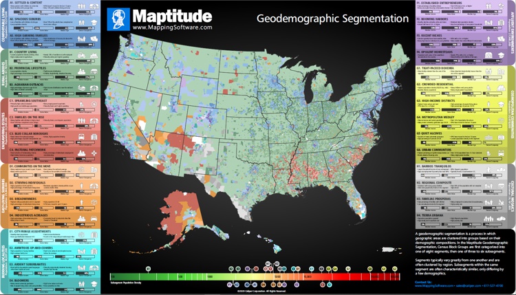
And even if you are provided with, or manage to wrangle yourself, a large amount of demographic data at a large scale, how can you make sense of it? Do you look at each characteristic in turn or do you try and chart them against one another? While an application such as Maptitude absolutely allows you to do this, it would be much more valuable if the data itself had specific categories of people that you could analyze. Enter geodemographic segments, a powerful information source for determining who your best customers are, where they are, and who is located where.
Next you will need to fine tune your analysis with expenditure and asset data to identify suitable prospects, counts by business category, whether areas are growing or shrinking demographically and financially, and whether these locations are predicted to continue to do so. Maptitude has you covered in all these scenarios.
OK, so these are not free, but not everything will be when using a business intelligence tool. However, products with a price tag are limited to only a handful of the Maptitude datasets available, and these are still much more affordable than can be found elsewhere when the additional demographics that are included, and data processing required to produce them, are considered. These map layers cover Census Blocks, Congressional and Legislative boundaries, and school districts.
Maptitude lowers the burden required for a successful location intelligence implementation, or project, or report. By integrating with key geographic, business, and consumer datasets, Maptitude provides a one-stop wizard-driven interface. Maps are an intuitive way to convey and analyze large amounts of data. Maptitude can support all the above analytics and comes with all the data used in the examples shown, as well as information for almost any industry and sector you would need to map.
Learn more about Maptitude to see how you and your team can can access the data critical to making successful business decisions!
Schedule a Free Personalized Demo

Home | Products | Contact | Secure Store
