Are you searching for a powerful mapping solution that goes
beyond the limitations of Google Maps? Look no further than
Maptitude, the robust Geographic Information System (GIS)
software packing a comprehensive suite of features for both
individual and professional users.
| Highlights |
|---|
- Support for Google Earth and Google Maps documents (KML, KMZ)
- Access to on-line images from Google Earth
- Ability to export your data and maps to Google Earth and Google Earth Pro to allow interactive file sharing
- Export maps directly to Google and Esri ArcGIS formats
|

|
“I have worked with Caliper products for 10 years as a transportation/urban planner and they have always fulfilled my needs. Maptitude/TransCAD software are easy to use, organized and robust: able to cope with large datasets without any problems. The user interface is very clear and easy to understand.
The exchange of data and databases across several formats is also very simple and functional. The two-way direct link with Google Earth makes my projects look really interesting.”
Gustavo Manzato
Professor |
|
Free Trial Request a Demo
Why Choose Maptitude Over Google Mapping Solutions?
While Google Maps is a popular option for basic mapping needs, it
lacks the advanced functionality and customization options offered
by Maptitude. Here's what sets Maptitude apart:
- Greater Data Depth: Maptitude boasts a vast
library of pre-built data sets, including
demographics, socioeconomic factors, and business listings. You
can also integrate your own data seamlessly for deeper analysis.
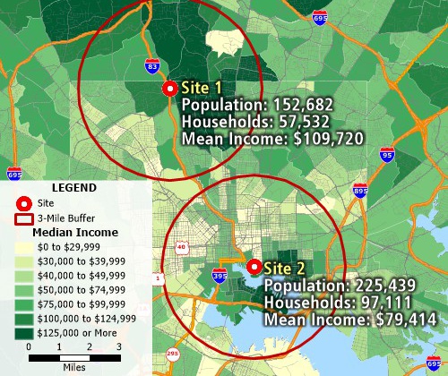
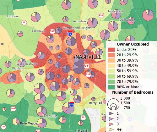
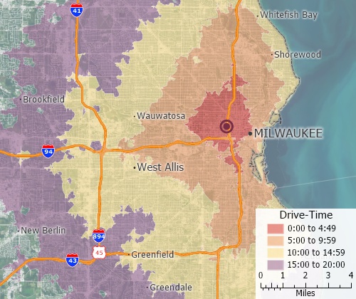
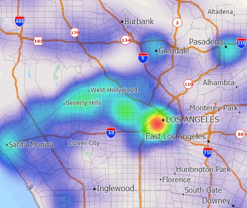
- Advanced Mapping Tools: Create thematic
maps, heat maps, drive-time maps, and more to visualize your
data in various ways.
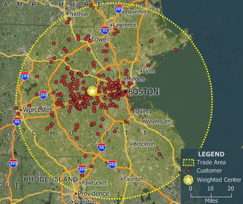
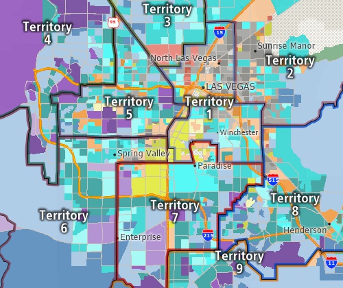
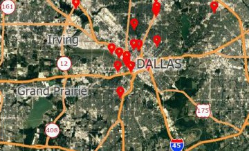
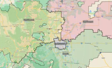
- Territorial Analysis: Plan and
manage sales
territories, service areas, and delivery zones with
sophisticated tools for territory balancing and optimization.
- Network Analysis:
Analyze transportation
networks, identify optimal routes, and solve complex logistics
problems.
- Redistricting Tools: Maptitude is the
preferred choice for political boundary
redistricting, used by state
legislatures, political parties, and public interest groups.
- Offline Capabilities: Access and edit your
maps even when you're not connected to the internet.
- Customization: Tailor the interface and
functionality to your specific needs and workflows.
- Cost-Effective: Maptitude offers various
licensing options to fit your budget, making it a more
affordable alternative to Google's advanced mapping solutions.

|
“Maptitude's ability to use my data for analysis and visualisation is phenomenal. Whenever I need to analyse my data and represent it visually I always go to Maptitude. The software is a GIS that
can import, covert and export Google Earth, OpenStreetMap, Esri Shape, MapInfo, GPS, AutoCAD, Excel, Text etc. I've been using Maptitude for more than 13 years and bar TransCAD (Caliper
Corporations Public Transit Modelling Solution), there is no other GIS software that delivers like this!”
Sheldon Cowie
Planning & Scheduling Consultant |
|
Maptitude: Your One-Stop Solution for All Mapping Needs
Whether you're a business professional, researcher, or simply
someone who wants to understand the world around you better,
Maptitude has the tools you need. Here are some specific scenarios
where Maptitude shines:
-
Marketing and Sales: Optimize your sales territories, target
potential customers, and analyze market trends.
- Real Estate: Identify ideal locations for new
properties, assess property values, and create compelling
marketing materials.
- Delivery and Logistics: Plan efficient routes, optimize
delivery schedules, and track your assets in real-time.
- Public Policy and Planning: Make informed decisions based on
data-driven insights, analyze traffic patterns, and plan for
future growth.
- Education and Research: Visualize complex data sets, create
educational maps, and conduct spatial analysis.
Maptitude vs. Google Maps Alternatives
Maptitude offers compelling advantages over various Google Maps
alternatives:
- Google Maps Lite™:
While free, Google Maps Lite lacks
the advanced features and data sets available in Maptitude.
- Google Maps Engine Pro:
Maptitude offers a more affordable
and user-friendly alternative with comparable functionality.
- Google Maps Engine Lite™:
Maptitude provides a more
comprehensive solution with offline capabilities and data
integration options.
- Google Earth Enterprise Portable Server™:
Maptitude offers a
more cost-effective and user-friendly solution for managing your
own map server.
- Google Earth Enterprise Client™:
Maptitude provides a more
affordable and feature-rich alternative for visualizing and
interacting with 3D maps.
- Google Earth API™:
Maptitude offers a more comprehensive set
of tools for customizing and integrating map data into your
applications.

|
“The package offers ease of use, an extensive range of functions & capabilities & a wealth of data. In fact, if I purchased the data separately, from any of multiple sources, the costs for data & restructuring would be over $20000.”
|
Free Trial Request a Demo
Dive Deeper: Maptitude vs. Google Maps Alternatives
Let's delve deeper into the specific advantages Maptitude offers
compared to various Google Maps alternatives:
Maptitude vs. Google Maps Lite:
- Advanced Features: While Google Maps Lite provides basic map functionalities, Maptitude offers a wealth of advanced tools for:
- Data Analysis: Analyze your own data alongside pre-built datasets for deeper insights.
- Cartographic Design: Create custom maps with advanced features like thematic maps and heat maps.
- Network Analysis: Optimize transportation networks and solve complex logistics problems.
- Territorial Analysis: Plan and manage territories, analyze customer distribution, and optimize sales routes.
- Data Sets: Google Maps Lite's data is limited, while Maptitude provides access to a vast library of pre-built data sets, including:
- Demographics: Analyze population trends, income levels, and educational attainment.
- Business Listings: Identify potential customers and competitors in your target area.
- Socioeconomic Data: Understand the social and economic landscape of your region.
Maptitude vs. Google Maps Engine Pro:
- Cost-Effectiveness: Maptitude offers a more affordable licensing model compared to Google Maps Engine Pro, making it accessible for businesses of all sizes.
- User-Friendliness: Maptitude boasts a user-friendly interface that is easier to learn and navigate than Google Maps Engine Pro.
- Offline Capabilities: Work with your maps even when disconnected from the internet, unlike Google Maps Engine Pro which requires an internet connection.
- Customization: Maptitude allows for extensive customization of the interface, map elements, and data visualization options, giving you greater control over your mapping experience.
Maptitude vs. Google Maps Engine Lite:
- Offline Capabilities: Access and edit your maps offline, providing greater flexibility and independence compared to Google Maps Engine Lite.
- Data Integration: Seamlessly integrate your own data with Maptitude for a more comprehensive and customized analysis.
- Advanced Features: Maptitude offers a wider range of advanced features, including drive-time analysis, territory management, and network optimization.
Maptitude vs. Google Earth Enterprise Portable Server:
- Cost-Effectiveness: Manage your own map server with Maptitude at a significantly lower cost than Google Earth Enterprise Portable Server.
- User-Friendliness: The intuitive interface of Maptitude makes it easier to set up and manage your map server compared to Google Earth Enterprise Portable Server.
- Flexibility: Maptitude offers greater flexibility in terms of data storage, user access, and customization options.
Maptitude vs. Google Earth Enterprise Client:
- Affordability: Access and interact with 3D maps for a fraction of the cost compared to Google Earth Enterprise Client.
- Feature-Rich: Maptitude offers a richer set of features for 3D visualization, including terrain analysis, fly-throughs, and interactive data exploration.
- Offline Capabilities: Explore 3D maps offline without relying on an internet connection, unlike Google Earth Enterprise Client.
Maptitude vs. Google Earth API:
- Customizable Integration: Maptitude offers a more robust set of tools for customizing and integrating map data into your applications, allowing for deeper integration and tailored user experiences.
- Data Options: Access and integrate the extensive data library of Maptitude alongside your own data for richer visualizations and analysis within your applications.
- Offline Capabilities: Develop applications that can access and display map data even when offline, providing greater flexibility and reliability.
Start Your Free Trial Today!
Ready to experience the power of Maptitude? Sign up for a free trial today and discover how
this versatile software can help you unlock the hidden potential of your data.
Free Trial Request a Demo