10 December 2025
The delivery route planning tools in Maptitude mapping software identify optimal routes for travel and deliveries among waypoints, calculate the distances between destinations, and produce driving directions.
Maptitude is a powerful delivery route optimization software that helps businesses save time, reduce fuel costs, and improve delivery efficiency. Whether you're managing a small fleet or coordinating large-scale logistics, Maptitude gives you the tools to create optimized delivery routes that meet a variety of operational goals: from speed and cost-efficiency to customer satisfaction and regulatory compliance. It adapts to your unique delivery scenarios and supports everything from local drop-offs to long-haul shipments with multiple stops and constraints.
Maptitude includes an extensive feature set tailored to delivery routing needs. Key features include:
These features allow you to tailor delivery routes with precision, meeting business needs while maintaining compliance with local and federal driving regulations.
With Maptitude, you can easily create and optimize multiple delivery routes by factoring in travel speeds, customer locations, time windows, and other logistics variables. The software offers robust capabilities to streamline route planning and elevate customer service. Key benefits include support for:
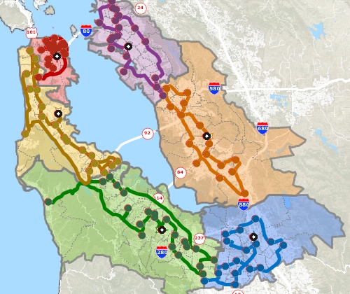
Maptitude also supports advanced use cases like clustering customer locations, multi-vehicle routing, and street-based territory creation for more strategic route management.
Beyond optimizing deliveries, route mapping software like Maptitude offers several key advantages:
Maptitude is applicable to a wide range of businesses and individuals, including transportation, delivery, and field service companies, sales teams, commuters, and travelers. Whether you're running a delivery fleet or managing field operations, these benefits make route planning software an essential part of efficient, sustainable logistics.
 |
“Using Maptitude to work out the closest members of staff to each store we visit has been incredibly helpful in reducing the travel done by our merchandisers, leading to positive environmental and financial results.”
|
Best delivery mapping software
Best route planning software
 |
“We have found Maptitude to be a really useful piece of software. It allows us to quickly and easily represent various data geographically, and the ease of functionality and ability to layer data makes it really user friendly. It has, among other things, helped us develop our sector-leading delivery service and understand areas that require focus from our sales teams.”
|

|
“Caliper produces the inexpensive Maptitude desktop GIS package which has extensive GIS-Transportation functionality.”
|
Start Optimizing Your Delivery Routes Now
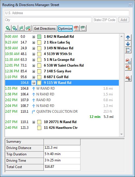
Example: One of the big issues you face, especially if you are a delivery service, is ensuring efficient fleet management to stay competitive. Even small reductions in transportation time or cost can add up to big savings for your company. Your delivery drivers may make multiple deliveries per shift, where each destination has varying stop times, may require rest stops, and based on vehicle type has varying speed constraints and fuel costs. Maptitude can handle these scenarios for you and uses sophisticated algorithms that ensure that your vehicles take the most time-efficient and energy-efficient routes while making multiple deliveries.
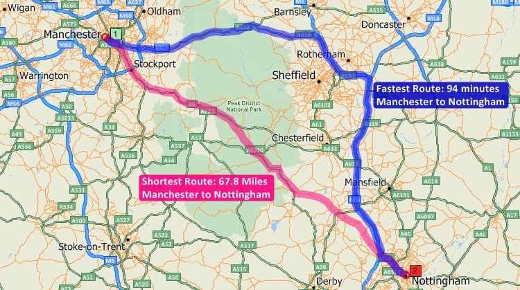
The best delivery route can mean different things to different people. Often the efficient route is the one that is the fastest, while others prefer the path that is shortest in terms of mileage, or a trip that maximizes use of highways, or avoids population centers:
Maptitude is the best routing software for meeting all of the demands listed above, and uses an accurate and up-to-date street database. Maptitude routing and scheduling software handles one-way streets, and supports display of these on the map.
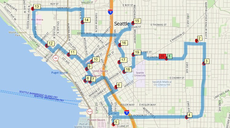
You can easily get started planning your route by simply clicking in a map on all the places you want to visit. You can also locate stops by typing an address, or automatically by using multiple addresses in an Excel spreadsheet or in any other table or database. If you have a point layer of your customers, you could select the customers you want to visit and then have Maptitude determine the best route to use to visit them.
There are also additional best route tools that allow you to:
Maptitude routing software Route Manager

|
“The User Interface [offers] tools and features that are only a few clicks away with excellent inbuilt support pages and examples. The overall experience is very good, with the tools and features and plug-ins, the majority of logistics analysis projects can be executed.” Paul Lucassen |
When planning long-haul delivery routes, analysts often need to model trips that run overnight or include custom rest periods. Maptitude delivery route optimization software allows you to create routes with flexible schedules, including overnight routes or trips with no fixed end time. Rest settings also support regulatory requirements, such as those for interstate truck drivers in the USA, helping ensure compliance while maintaining efficiency. Additionally, you can cluster customer locations and optimize routes for each group, making it easier to manage large-scale deliveries and reduce travel time, fuel costs, and operational complexity.
Cluster your customer sites for route optimization
Create multi-day routes with built-in rest times
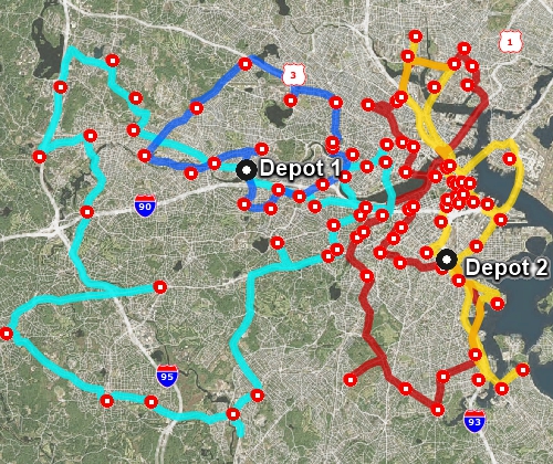
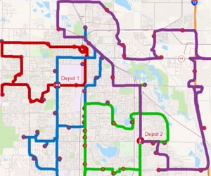
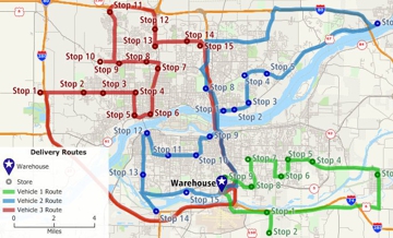
When you need a multiple route planner, Maptitude helps you optimize each route by deciding which stops should be visited by which driver and vehicle. Maptitude even lets you choose the capacity and types of vehicle, supporting analysts that need:
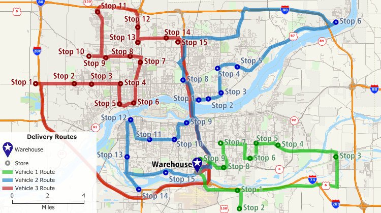
Vehicle routing with time windows, vehicle constraints, multiple depots, route length constraints, and mixed pickup and delivery
Route optimization software helps organizations across many industries reduce operating costs, improve service reliability, and handle growing expectations for fast delivery. Businesses that manage fleets, field teams, or multi-stop operations typically see mileage reductions of 10-30% and fuel savings of up to 20%. The following sectors rely on these capabilities to streamline operations at scale.
 Retail and E-Commerce
 Retailers and e-commerce companies use route optimization to manage high-volume last-mile delivery, the segment that accounts for up to 53% of total shipping costs.
 Food and Beverage Delivery
 Food and beverage distributors require precise timing due to product perishability and customer expectations for freshness.
 Healthcare and Home Care
 Healthcare providers use route optimization to coordinate home health visits, medical equipment delivery, and patient transport within strict appointment windows.
Related: How Maptitude supports healthcare delivery route planning
 Field Service and Maintenance
 Field service companies depend on route optimization to maximize billable hours and minimize windshield time for technicians handling both scheduled and emergency calls.
Logistics companies manage complex operations involving multiple depots, vehicle types, and regulatory constraints such as hours-of-service rules.
 Utilities and Public Services
 Utilities and municipal agencies use route optimization for meter reading, waste collection, infrastructure inspection, and emergency response across large fixed territories.
 Sales and Merchandising
 Outside sales teams and retail merchandisers use route optimization to maximize face-to-face selling time and ensure equitable territory coverage.
Related: How eXPD8 Analytics reduced fuel consumption with Maptitude
Maptitude provides the routing, scheduling, and territory tools these industries need to reduce costs, improve efficiency, and deliver reliable service at any scale.
Planning your delivery routes for anything from food delivery to service calls requires robust analytics.
Learn more about Maptitude Buy Now
 Check out our G2 Reviews
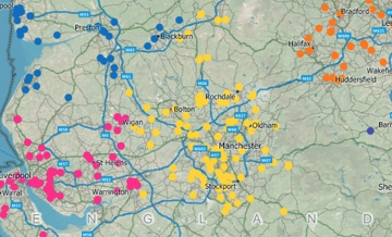
1 Insider Intelligence
2 NIST
3 University of Vermont
4 UMass
5 Transportation Science
Home | Products | Contact | Secure Store

