

Author:
Stewart Berry
Images: Dan Martin
As healthcare networks begin to deploy COVID-19 vaccine services, how do you ensure that homebound patients get their coronavirus vaccines as quickly as possible? Mapping software or GIS (Geographic Information Systems) are tools that are ideally suited to enabling analysts to optimize vaccine distribution.
In this post we explain how Maptitude mapping software can aid in the planning of vaccine delivery for homebound patients.
The optimization of vehicle routing and delivery scheduling is vital for many public health, government, and private (business logistics) operations and involves determining how many vehicles are required to service the destinations and developing a route and schedule for each one. These tools are well placed to assist with modelling vaccination distribution.
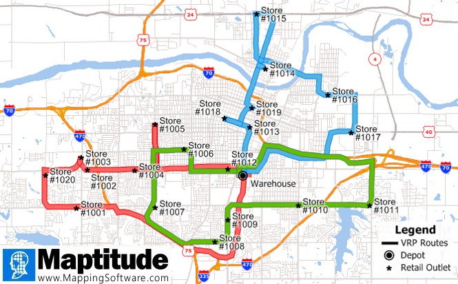
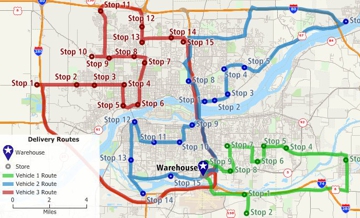
A company has one warehouse that supplies 20 retail stores. Each day, trucks must deliver goods from the warehouse to each store, and then return to the warehouse. Each truck has a fixed capacity (a limit on the weight or volume). Each store has demand, which is the weight or volume of goods that must be delivered each day. The company must determine the number of trucks that are needed to meet the demand at each store and find cost-efficient routes for each truck.
The starting points for each route (such as the warehouse in the above example) are typically known as depots, and the points to be visited are often referred to as stops. A vehicle route starts at a depot, visits one or more stops, and may or may not return to the depot. In the case of vaccination delivery, it is the shelf-life measured in hours of vaccine doses after first opening the vial that is of most concern, such that returning to the depot is not a critical part of the model. The goal of the procedure is to obtain a set of routes that minimizes the total time or distance travelled by the entire fleet of vehicles.
Many factors make a vehicle routing problem more complex such as multiple depot locations, time restrictions on when deliveries can be made, depot restrictions such as when deliveries can start, time delays at each stop, time restrictions on total route length or route duration, a need to balance the routes based on the number of stops or the distance/time travelled, or capacity restrictions on the delivery vehicles themselves, and mixed vehicle fleets. Applications such as Maptitude can handle all these factors.
These models are well suited to vaccine delivery since such routes typically do not have complexities such as:

In modeling how vaccinators visit patients there are many variables to take into consideration, such as:
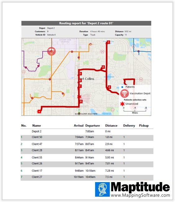
With Maptitude, your first step is to prepare the patient addresses in a spreadsheet or database table such as Excel or Microsoft SQL Server. These locations are then automatically plotted on a map in preparation for calculating the best routes to reach as many patients as practicable with the fewest number of trips possible, ensuring that the vaccines are completed within the vial's time window.
We use multiple starting locations, with multiple vehicles containing vaccines at each of the two starting depot addresses. A route for each vehicle is sequenced from start to finish, giving the order that the Maptitude mapping tool recommends the visits be performed. The routes are distinguished by color, and the stops numbered. These stops and routes can be queried, and a PDF report created for each driver or for all routes.
The flexible vehicle routing tools in Maptitude allow you to respond rapidly to vaccination route planning requests, requiring little expertise with GIS software, and allowing you to build models and procedures in times as short as minutes, rather than hours or weeks.
In addition to the tools discussed above, you can easily click-drag patients between routes and add or remove them from the delivery schedule of a particular vehicle. You can also delete routes to rebalance visits by running a truck from another depot, to handle scenarios such as a vaccinator calling out sick.
Wastage of vaccinations has been of critical concern as distribution has rolled out across several countries. Any tool that can help reduce waste, not only of vaccines, but also of fuel and medical staff time is of great value.
Healthcare networks can use Maptitude to prepare routes ahead of time and to coordinate visits with patients. People on each delivery path will know when to expect their appointments, and vaccine providers will be able to contact patients to provide an exact time.
The routing solution can save time and money. Maptitude takes the complexity out of vaccination planning, optimizes vaccination delivery routes, and avoids chaotic journeys and increased journey times. Not only will delivery take less time, but more doses will be given per day. The decreased number of days needed for vaccinations will decrease the cost of delivering a vaccination program.
The Maptitude mapping solution can be used to boost vaccination preparation for homebound patients receiving their first round of vaccinations, as well as to schedule any subsequent rounds of vaccinations, making these visits more effective.
Using the intuitive Wizard-driven interface in Maptitude, you can model the patient data and transform your requirements into logical solutions, to deliver a plan in hours rather than weeks, and without needing GIS expertise which limits the ability to utilize mapping technology. With these vehicle routing tools and data already integrated into Maptitude at no additional cost, the solution is ready to be used by healthcare networks in a minimal amount of time.
Patient confidentiality can be protected by excluding personal details from the optimized route direction plans. Patient name and contact details would only be seen internally by the healthcare network staff that are using Maptitude. The Maptitude solution is low cost and can be run completely offline, ensuring that it is secure, affordable, accessible, and easily deployable. In addition, there are secure Cloud-based map sharing options for those requiring online access to the routes.
The mapping data provided is the most accurate available, not only for the USA, but for many countries around the world. As a HERE Maps partner, Maptitude includes road and traffic data products that ensure the accuracy of the models. To calculate the routes, Maptitude uses HERE street networks. Maptitude also includes a robust geocoder that allows for unlimited address mapping, without additional charges or credits when plotting patients, origins, and destinations.
Maptitude lowers the burden required for a successful vehicle routing implementation, project, or report. By integrating with key geographic, demographic, and healthcare datasets, Maptitude provides a one-stop wizard-driven interface. Maps are an intuitive way to convey and analyze large amounts of data. Maptitude can support all the above analytics and comes with all the data used in the examples shown, as well as information for almost any industry and sector you would need to map.
Learn more about Maptitude to see how you and your team can access the data critical to making successful logistical decisions!
Schedule a Free Personalized Demo
This blog is for illustrative purposes only, and does not constitute medical, or any other, advice.
Home | Products | Contact | Secure Store

