Maptitude 2019 Released!
|
 |
Intuitive mapping software. Simple file management. |
|
Maptitude 2019 has new premium data, new features for MapPoint users, and uses a single document for saving and sharing your maps.

|
“We are able to do things with Maptitude that we had not dreamed of doing before (using MapPoint and Territory Mapper). There are so many possibilities, that you can easily create a mapping solution that perfectly meets the need of your business model.” Matt Ardoin |
 |
“Tried Maptitude out looking for a simple mapping software, and got so much more. Definitely worth the purchase. The support team is above par and are always available for any question.” Tania Bourque |
Maptitude 2019 now includes one of the best features of Microsoft MapPoint, the ability to share and save your work using a single document! Maptitude 2019 can compress all of your windows, tables, and map layers into a single file for sharing. In addition, you can autosave and file lock your workspaces to protect your work and prevent accidental overwriting.
Support for discontinued Microsoft MapPoint and Streets & Trips files makes Maptitude the obvious replacement for those products. Maptitude 2019 imports waypoints directly into the Routing Manager, along with settings such as arrival and departure times, and supports MapPoint shapes/lines/text and the ability to edit them.
Maptitude 2019 also enhances your ability to update your map with changes made to your data source. In addition to updating geocoded point locations, you can update areas with changes in your Excel spreadsheet or SQL Server database.
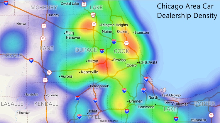
The Density/Heat Layer tool has an improved visual style
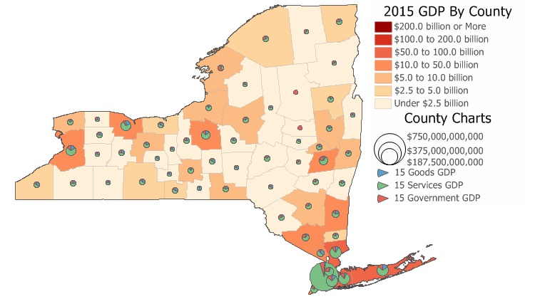
New U.S. data provide access to the most up-to-date geographic information available. Only Maptitude 2019 users will have access to completely new business-critical data. Now included are 18 new fields covering personal income, unique households, and GDP. We will also be updating our free premium data for Maptitude 2019 customers.
The boundaries (e.g., tracts, ZIP Codes, counties) have updated demographics and Census data such as buying power/disposable income, banking compliance data, and 2017 Census ACS data.
Maptitude 2019 also ships with the January 2019 ZIP Code boundaries, ensuring that you are using the latest nationwide postal data.
The 2019 U.S., Australia, Brazil, Canada, Mexico, New Zealand, and United Kingdom & Ireland country packages all include updated streets that allow for accurate address locating and street visualization, directions, drive-time rings, and drive-time territories.
Map background imagery layers draw faster and with better resolution.
You can create travel time or distance tables that identify the closest locations (e.g., the ten closest customers or ZIP Codes to every store based on drive-time, drive-distance, or straight-line distance).
Export to Excel reports can be customized, allowing you to choose which analytics to provide (e.g., drive-time and distance from your locations), which locations to include, and whether to use all locations or just those visible in the map. Maptitude 2019 also allows you to choose from all of the demographic variables supplied with the software which to use in your reports.
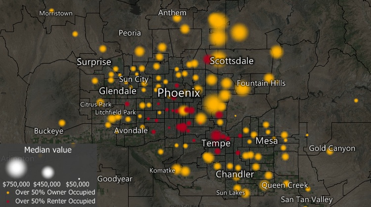
New point layer styles list 395 new icons and support creation of firefly cartography (or glow-maps)
Click here to see features that were new to Version 2018.
Home | Products | Contact | Secure Store