Map your Excel data now for free
10 October 2025
Maptitude is a powerful desktop and online mapping software that allows you to create and analyze maps from Excel data. With Maptitude, you can easily:
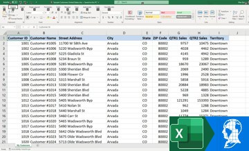
Most businesses store the data they want to map in an Excel spreadsheet. With Maptitude there are no extra costs to map your Excel data after your purchase or subscription. Maptitude does not use credits or transaction fees. This means that you can create as many maps as you want for free from your tables of information. You can create a variety of maps that allow you to share and report on your business-critical findings.

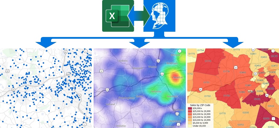
ZIP Code mapping software Excel: Map your spreadsheet data from Excel into map views to see your data aggregated by ZIP Code

Map Excel data: Show your data from Excel in map views with colors, charts, dots, and more with Maptitude mapping software

Get your data from Excel into map views: Excel mapping with Maptitude lets you locate your spreadsheet data with street level accuracy

Mapping Excel data with Maptitude lets you find hidden patterns in your spreadsheets by illustrating where your customers are located and by aggregating your Excel data to postal/ZIP codes, territories, and more
There are many benefits to using Maptitude, including:
This case study discusses the benefits of using Maptitude mapping software and the limitations of Excel for clustering site locations based on service contract requirements.
Maptitude Advantages:
Excel Limitations:
The advanced features and flexibility of Maptitude make it more suitable for the strategic management of service contracts compared to the manual and time-consuming approach to do the same tasks using Excel.

|
“We believe the capabilities of Maptitude are promising when compared to Microsoft Excel–based mathematical clustering because Maptitude provides greater information integration, including the ability to layer information.”
|
1. Boosting Sales Efficiency: Imagine a sales manager with a spreadsheet of target accounts and their locations. Maptitude seamlessly integrates this data, creating a visual map that reveals geographic clusters. They can then optimize routes, assign territories strategically, and identify under-served areas, leading to up to a 20% increase in sales visits and up to a 15% rise in closed deals.
2. Pinpointing Profitable Locations: A retail chain with Excel data on store performance and demographics uses Maptitude to overlay income levels and population density. These maps reveal underserved high-income areas, guiding them to open a new store in a prime location, leading to up to a 30% surge in revenue within the first year.
3. Visualizing Customer Behavior: An online retailer analyzes customer purchase data in Excel. Maptitude maps buying locations, identifying regional preferences and uncover unexpected trends. This helps them tailor marketing campaigns and product offerings to specific regions, resulting in up to a 12% increase in targeted conversions.
These are just a glimpse into the diverse applications of Maptitude for Excel data. Its ability to transform numbers into insightful maps empowers businesses and organizations across various sectors to make data-driven decisions, optimize operations, and unlock hidden potential.
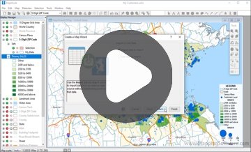
To create a map from Excel data in Maptitude, simply follow these steps:
Mapping Excel data in Maptitude Online is as simple as dragging and dropping
To change the customer theme:
• Click
![]() to see the list of layers in the map
to see the list of layers in the map
• Click + to expand "My
Customer Layer" in the legend
• Click on the "Cluster
Theme" drop-down menu and choose one of the available
visualizations for the mapped Excel locations
Here are some examples of how Maptitude can be used to create and analyze maps from Excel data:

|
“You can easily import data to and from Excel, build multiple/quality custom Maps and overlay demographics and sales data. It's a GIS Jackpot!”
|
 |
“Maptitude is excellent for doing geographic analysis projects looking at: where existing customers are and new ones might be (including using the built-in demographic data); identifying hot-spots, patterns and trends that can't be seen in Excel.”
|
 |
“We use Maptitude extensively for running complex Territory Alignment scenarios. The depth of the product, its total utility and functionality is immense. Import-Export capability with Excel is seamless. It is easy to work with and Maptitude support is second to none. My complements to the Maptitude team: They have created a solid product and it is one of the best software investments we have made as an organization.”
|
 |
“[Maptitude] imports and exports data back and forth to and from Excel, allows Dataviews to be edited from other geographic files (counts of point data within areas, distances from points or area centroids, etc.), allows color combinations based on templates or user choices, and even allows users to tap into Census data....In addition, the datasets that Caliper makes available for free for users are amazing.”
|
Creating a map from Excel spreadsheet data is easy with Maptitude, a powerful mapping software that offers a wide range of features and benefits.
Benefits of using Maptitude for Excel mapping:

With an internet connection, you can access Google Maps imagery or export your maps to Google Earth
Maptitude is the best mapping software for Excel data because it offers a wide range of features and benefits, including:
Learn more about Maptitude to see how you and your team can benefit from mapping software!

 Check out our G2 Reviews
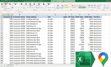
Home | Products | Contact | Secure Store
