Location mapping software is a computer system that allows you to map, model, query, and analyze large quantities of data within a single database according to their location. Map location software gives you the power to create maps that integrate information from multiple sources and allow you to visualize patterns and develop effective solutions.
Maptitude is competitively priced and enables organizations and businesses to use their location-based data to improve decision making. Why spend more for less?
Use location mapping software to find spatial patterns from vast collections of data.
Map location software can be used to pinpoint data to an exact address and study its relationship to other locations.

|
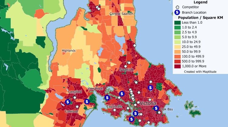
“If you are looking to expand a retail business with new locations, do not try doing it without using Maptitude. Among other things, Maptitude allows you to evaluate potential locations anywhere in the U.S. (also internationally) and examine the demographic profile of customers based on location parameters that you set. In addition, it allows you to map competitor locations and other locations that may be pertinent to your analysis. Basically, it takes the guesswork out of selecting a business location.”
|
 |
“Maptitude allows me to know my market by demographics. It is a key tool is determining emerging markets for products as well as identifying like markets to capitalize on success of a product. It also allows me to then graphically present the locations of the winning markets. I have used this software in an older version and came back to them for an upgrade to take my analytics business to the next level.”
|

Maptitude Demo |
Maptitude |
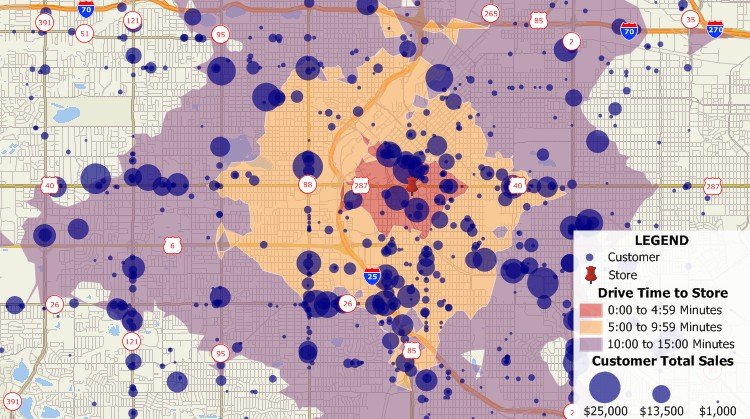
Maptitude creates the best location maps! Here's why:√ Maptitude is the easiest-to-use full featured mapping software, and includes powerful tools such as multi-ring drive-time zones √ Maptitude has no subscription fees, and supports secure off-line data storage
√ Maptitude provides fully customizable maps with unlimited point icons √ Maptitude has unlimited pin-mapping/geocoding √ Maptitude includes free mapping data and demographics (where available) covering everything from population statistics to business locations, postal/ZIP Codes, and more! |
 Check out our G2 Reviews
Home | Products | Contact | Secure Store
