By Stewart Berry
31 October 2025
Maptitude mapping software is robust and easy-to-use professional business map software. Maptitude offers unique location-based analytics and contextual visualisation tools to provide actionable insights for business data analysis in real time.
Maptitude provides all the features that your organisation requires in order to take advantage of geographic data, and to effectively visualise information through the power of maps. These tools facilitate tasks such as managing territories, optimising routes, analysing market performance, and visualising customer data. It offers comprehensive, user-friendly, and cost-effective spatial intelligence solutions that meet diverse business needs.
Maptitude mapping software costs only US$795 and is packaged as a one-stop-solution for businesses, shipping with all the tools and data required to geographically explore your markets. These include demographics and address/postal geocoding, plus Maptitude has a variety of wizards to help you get the answers you need.
 |
“Powerful, well thought out, intelligently crafted, efficient, cost effective. Having worked with a few different GIS packages in the past, I'm impressed to note Maptitude is a comprehensive blend of best features that are more than likely to meet the needs of most users.”
|
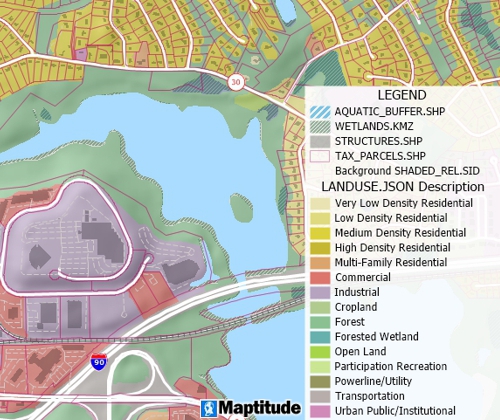
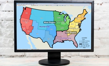
Maptitude is the best mapping software for territory management. Maptitude map software gives you a suite of tools that you can use to create districts and regions for your business mapping needs.
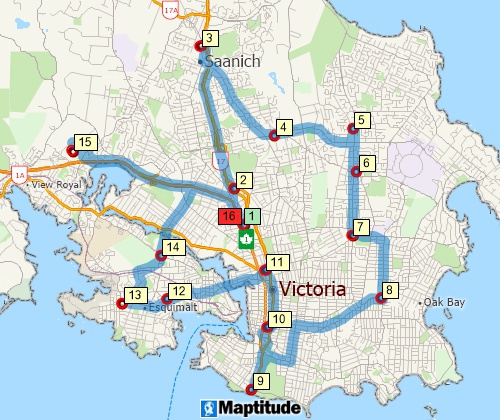
The trip planning tools in Maptitude identify optimal routes for travel and deliveries, calculate the distances between destinations, manage vehicle fleets, and produce driving directions.
Maptitude is a powerful combination of mapping software maps and geographic data. Maptitude provides everything that you need to make informed decisions and get the maximum return on your sales and marketing budget.
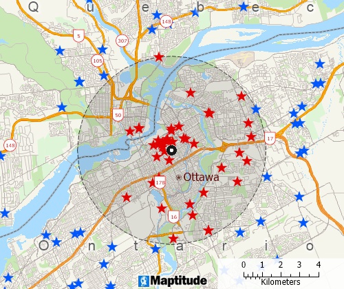
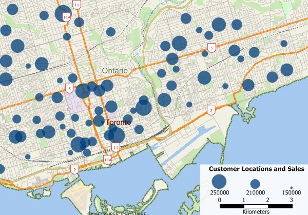
Maptitude Pin Mapping Software can instantly plot unlimited numbers of locations from a spreadsheet, with options to colour-code and filter based on specific attributes.
Data Import Capabilities allow seamless incorporation of business data from sources like Excel, CRM, or ERP systems for comprehensive analysis.
Data Analytics Tools help organisations monitor performance and identify areas for improvement through spatial insights.
Interactive map software with real-time clicking, zooming, and filtering capabilities to explore patterns, trends, and anomalies for diverse business needs.
Learn More
User-friendly interfaces and step-by-step Wizards simplify map creation and workflow visualisation.
Since 1995, Maptitude has been helping businesses of all sizes leverage the power of location-based analysis, a capability often limited to large corporations. Designed for usability, Maptitude empowers all business analysts to make smarter, data-driven decisions quickly and efficiently (read reviews here).
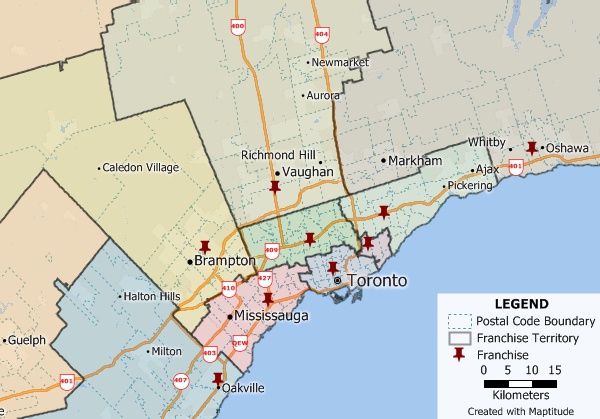
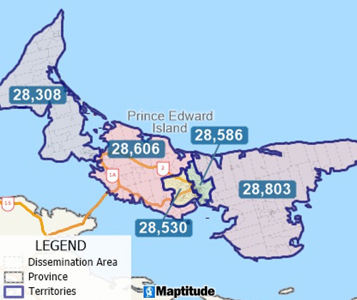
Create, manage, and balance map territories to suit your business needs
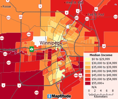
The Canada data package includes streets for the entire country with address and postal code ranges that you can use to locate your facilities and customers.
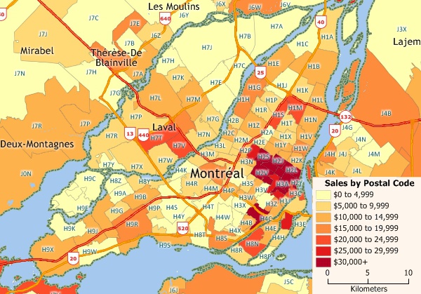
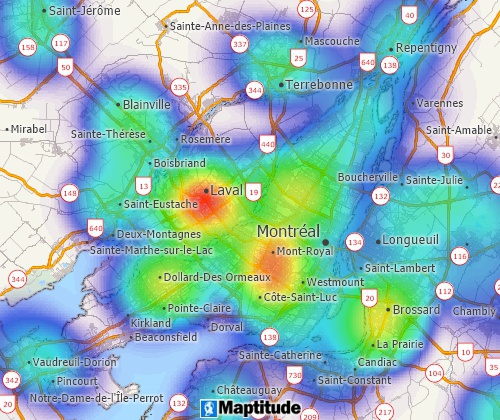
Aggregate your data by postcode to spot geographic patterns in your data.
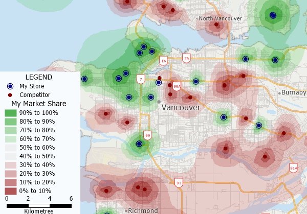
Perform market share analysis with Maptitude business mapping software for Canada.
Maptitude is flexible, intuitive and affordable. Graduate from basic mapping applications without overpaying for a system that underperforms. Contact Maptitude Sales today at: sales@caliper.com.
 |
“I have used Maptitude to expose undergraduate and graduate students to the power of GIS. The built in data and map layers allow the students easily perform advanced spatial analysis and data visualization with a minimal amount of training. The automated trade areas provide for advanced network analysis that can be fed into AI systems to provide a new dimension which have improved predictions. I would recommend this software to any company looking to bring spatial analysis capabilities to their organisation. The minimal cost is well worth it.”
|
Choosing the right business mapping solution can be time-consuming. Fortunately, Maptitude has emerged as the clear choice for business development professionals, offering a seamless experience and a wealth of features. Here's what some satisfied users have to say:
 |
“Tried Maptitude out looking for a simple mapping software, and got so much more. Definitely worth the purchase. The support team is above par and are always available for any question.”
|
 |
“The support team is fantastic and always quick to respond. Thank you! Also the new features in the Maptitude program make my job easier! Thanks!! Favorite aspect of this product? Ease of use as well as being able to find out specific info within my drive rings. This is a great product that I have had to learn to use, with no training which has been fairly easy.”
|
 |
“I appreciate Maptitude’s comprehensive GIS tools and user-friendly interface. It allows for powerful spatial analysis and map creation without requiring deep technical expertise. My overall experience with Maptitude has been very positive. It’s a powerful tool for geographic and market analysis, offering detailed data and strong mapping capabilities. While some processes can be slow with large datasets, the results are reliable and valuable.”
|

|
“I was in a bind when MS retired MapPoint. I discovered Maptitude in 2009 and have been using the software since then. Once you take time to use the various features, it becomes a joy to use when evaluating different market conditions/situations. I do enjoy using this software.”
|

|
“Pros: Cost. Much easier to reach a purchasing decision. I loved the integrated country data package so I didn't have to download census layers and other info - it was all built in.”
|
Business mapping software helps organisations visualise and analyse geographic data. It shows where customers, markets, and competitors are located, allowing smarter decisions about sales, service areas, and business expansion.
Yes. Maptitude imports data from Excel, Access, CRM systems, and other formats so you can link your business information with maps. This lets you explore territories, uncover opportunities, and improve decision-making with location intelligence.
Yes. Maptitude is built for organisations of any size. It is easy for beginners to use yet powerful for advanced analysis, making professional mapping affordable and scalable for every business
Yes. Maptitude includes both desktop and browser-based options, with mobile and offline access for field teams. Your maps and data travel with you, enabling collaboration and insights anywhere.
Maptitude starts at US $795 and includes everything you need: mapping tools, demographic data, business listings, and map-based analysis features. It's a complete solution for territory management, market analysis, and route planning.
Learn more about Maptitude to see how you and your team can benefit from business mapping software!
 Check out our G2 Reviews
Home | Products | Contact | Secure Store

