



Author: Stewart Berry
Maptitude, a G2 Leader in GIS, geocodes your addresses with no additional fees, credits, or record limits, at a fixed price of $795 a year
30 September 2026
In 2026, unlimited batch geocoding software continues to play a vital role in how organizations use their address data, converting vast lists of addresses into precise latitude and longitude coordinates. From customer lists in a CRM to store, patient, and delivery addresses, geocoding turns raw location data into something meaningful and actionable.
Batch geocoding is becoming increasingly essential for a variety of purposes, from routing and territory design to site selection and targeted marketing. Before deciding, you should evaluate which features are offered, the pricing, and any advantages or disadvantages.
This page compares five unlimited batch geocoding tools. Each one links to its own independent profile, alongside buttons that run a comparison against Maptitude on the AI tool of your choice. We will start by explaining what batch geocoding software is and the key features that define a strong tool. Or use the table of contents to skip straight to the platforms.
In this article:
What Is Batch Geocoding Software?
Key Features to Look for in Unlimited Batch Geocoding Software
5 Unlimited Batch Geocoding Tools Compared for 2026
What Teams Use Batch Geocoding For
Geocoding adds coordinates to your location data. Batch geocoding software does it for whole lists of addresses at once, and reverse geocoding finds the closest address to a point you click on the map or to a coordinate.
It works at different geographic levels. Records can be located by address, intersection, ZIP or postal code, town, coordinates, or a click on the map, and data can be geocoded to regions such as counties, states, census tracts, or custom-defined areas.
It has been decades in the making. Early GIS systems of the 1960s to 1980s used simple point matching, and DIME (Dual Independent Map Encoding) made it possible to interpolate addresses along street segments. Desktop software of the 1990s and 2000s moved from street-segment approximations to parcel-centroid precision and added reverse geocoding, and geocoding APIs in the 2010s made processing millions of addresses feasible through automated background tasks. Today, modern SaaS and online batch geocoding leverage cloud-native infrastructure to allow users to instantly process and enrich massive datasets through simple, drag-and-drop web interfaces without requiring any coding or local hardware.
We have been selling mapping software for forty years. These are the questions that come up every time. Ask them about every tool you look at, including Maptitude.
Here are five unlimited batch geocoding tools, each with a link to its independent profile and AI comparison tools so you can evaluate it against Maptitude yourself.
Maptitude distinguishes itself by offering genuine, unrestricted batch geocoding without supplementary fees, credit systems, or record limitations. Its high-quality street data and versatility in managing various geocoding types make it a robust option.
Among the many tools that claim “unlimited” batch geocoding, Maptitude stands out by offering truly unrestricted processing without extra per-record fees, credit systems, or hidden quotas. You get a complete mapping and analytics environment that includes a powerful geocoder rather than just a bare API.
Truly unlimited, with a straightforward pricing model
With Maptitude, you’re not constantly watching usage dashboards
or worrying about overrunning your monthly credits. You can geocode
as many records as your hardware can handle under a clear license,
which is especially valuable for organizations that process large or
frequently changing datasets.
High-quality, included data out of the box
Maptitude ships with detailed street data and rich geographic
layers, so you can geocode immediately without sourcing and
maintaining separate base maps. Because the software understands
addresses, streets, postal codes, and boundaries, it can return
precise locations and attach useful geographic attributes to each
record.
Precision plus analytical depth
Maptitude
doesn’t stop at putting points on a map. Once your addresses are
geocoded, you can:
This analytical depth means you get insight, not just coordinates.
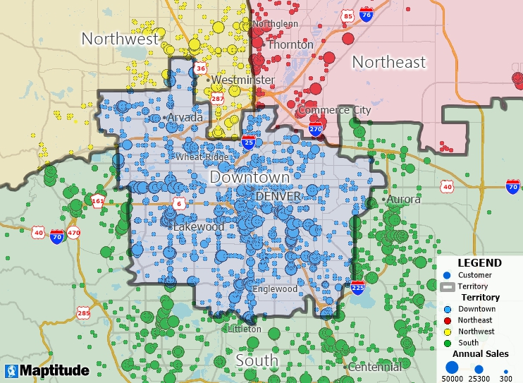
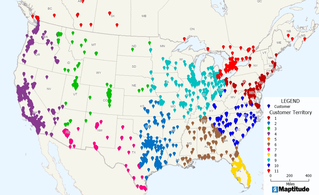
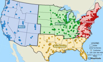
Geocoded customers, their sales, and the territories to which they belong
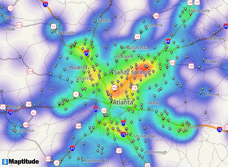
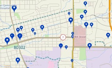
Geocoded customers and a heat map based on those locations
Offline capability and data privacy
Because
Maptitude runs on your desktop, you can
geocode sensitive address data locally instead of sending it to an
external web service. That’s a major advantage when working with
customer, patient, or citizen information subject to privacy or
regulatory requirements.
Cloud and Online
For cloud-based workflows,
Maptitude
Online offers simple drag-and-drop geocoding through a browser,
making it easy for non-technical staff to upload spreadsheets and
get instant mapped results. Geocoding in Maptitude Online is also
unlimited,* at a fixed $795 a year with no per-record charges. Maptitude Online geocodes on Maptitude-managed
infrastructure, so your addresses are not sent to third-party APIs. Together, these options give you a
flexible hybrid approach: automated geocoding when you need scale
and control, and browser-based tools when you need fast, accessible
mapping for everyday tasks.
Geocoding Excel data in Maptitude Online is as simple as dragging and dropping
Flexible workflows for every team
Non-technical users can drag-and-drop spreadsheets, geocode step by step
with the Maptitude Create-a-Map Wizard, and immediately see results on a map. Technical
teams can automate repeatable workflows, integrate with other
systems, and script large jobs, which is ideal for ongoing,
high-volume use.
GISDK API
For teams that need automated,
repeatable, and fully controllable geocoding workflows, the
Maptitude GISDK scripting API provides a direct path to high-volume
processing without external dependencies. You can script entire
geocoding pipelines, trigger batch jobs from other systems,
standardize address inputs, and export enriched results in formats
ready for analytics or downstream applications. This level of
automation is ideal for organizations that routinely process large
or frequently updated datasets. The Data.Geocoder class geocodes
entire tables, trying address, postal code, and city in turn, and reports the
geocoding precision of each record.
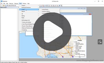
See unlimited batch geocoding in action
If
you’re ready to move beyond limited web tools and per-lookup fees,
Maptitude gives you the freedom to geocode at scale and the tools to
put that data to work.
Use the Free Trial and Request a Demo buttons on this page to explore how Maptitude can handle your unlimited batch geocoding and mapping workflows end to end.
Third-party recognition. In the G2 Summer 2026 reports, Maptitude is a Leader in GIS across the overall, Enterprise, Mid-Market, and Small Business segments, with further GIS badges including Best Support, Best Results, Momentum Leader, and Users Most Likely To Recommend. The 2026 G2 buyer's guide to the best GIS software names Maptitude best for territory mapping and demographic analysis, with the highest geocoding and likelihood-to-recommend scores in the guide. Maptitude is rated 4.7 out of 5 from 150 verified reviews on G2 and was named a Top Software Product in the G2 2026 Best Software Awards, placing in the top 0.63% of all vendors. Maptitude developer Caliper Corporation was named to the Geoawesome Global Top 100 Geospatial Companies, 2026 Edition. See all Maptitude awards.







Maptitude G2 badges in GIS, Summer 2026
In 2026, Maptitude introduced refreshed data: October 2025 HERE street data, 2024 ACS demographics, the January 2026 ZIP Code update, and population projections in 5-year steps to 2054 down to Block Group and ZIP Code level. See the full Maptitude 2026 feature list.
Pricing. Maptitude costs a fixed $795 a year per user, with one-time purchase and subscription options, including one free Country Package and unlimited geocoding on the desktop.
Maptitude offers a free, no risk, 1-month trial with no credit card required, so you can start mapping now.
Use the buttons below to get an independent AI comparison of Maptitude and Maptitude Online against the other platforms on this page:

|
“I like the easy geocoding of addresses and the ability to analyze socioeconomic data with just a few clicks.”
|

|
“I have been using Maptitude for 25+ years. It is essential for my custom demographic consulting company’s work, which includes analysis of spatial data and presenting results to public sector clients. The tools to prepare finished maps are excellent. The geocoding tool is excellent. The software is easy to use and has evolved over time to improve with each new release. Tech support is excellent. Caliper staff members answer emails and phone calls promptly and have always continued to help us until problems are solved. Best of all, the software is relatively inexpensive, especially for such a powerful tool!”
|

|
“So we needed a product that would allow us to map where our customers are located and be able to analyze demographics. Overall, considering this is a one time buy and not a SaaS, it has excellent value. The ability to overlay your data with demographic information is awesome.”
|

|
“What do [I] like best? The capacity to create your own maps without knowledge of programming....Easy to use and affordable. No need to upload information or customer database. All Info stays on your computer and not on the cloud.”
|
Maptitude Desktop Free Trial Maptitude Online Free Trial
For a current, independent description of BatchGeo, see their profile on G2, and compare it to Maptitude: g2.com/compare/maptitude-vs-maptitude-online-vs-batchgeo →
Use the buttons below to get an independent AI comparison of Maptitude vs BatchGeo:
Source: Wikipedia – Esri ArcGIS
See Wikipedia for a current description of Esri ArcGIS.
For a current, independent description of Esri ArcGIS, see their profile on G2, and compare it to Maptitude: g2.com/compare/maptitude-vs-maptitude-online-vs-esri-arcgis →
Use the buttons below to get an independent AI comparison of Maptitude vs Esri ArcGIS:
For a current, independent description of Geocodio, see their profile on G2, and compare it to Maptitude: g2.com/compare/maptitude-vs-maptitude-online-vs-geocodio →
Use the buttons below to get an independent AI comparison of Maptitude vs Geocodio:
Source: Wikipedia – Google Maps Geocoding API
See Wikipedia for a current description of Google Maps Geocoding API.
For a current, independent description of Google Maps Geocoding API, see their profile on G2, and compare it to Maptitude: g2.com/compare/maptitude-vs-maptitude-online-vs-google-maps-platform →
Use the buttons below to get an independent AI comparison of Maptitude vs Google Maps Geocoding API:
These are common reasons organizations geocode their address data, with results reported by Maptitude customers:
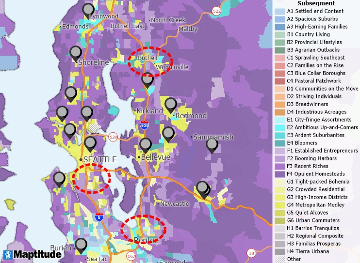
Geocoded stores and the underlying neighborhood demographic characteristics
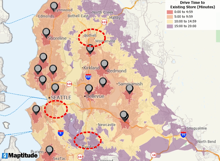
Geocoded stores and 5-minute interval drive-times to those stores
Open-source mapping tools such as QGIS can be powerful, and many organizations use them effectively. However, they do not come with the commercial infrastructure that Maptitude provides as standard: a full-time development team with over 40 years of GIS experience, dedicated support staff rated 9.2 out of 10 for Quality of Support by G2 reviewers, commercial-grade street data for geocoding, free training, and a fixed annual subscription that covers all updates and support with no added costs.
For those seeking unlimited batch geocoding that stands out in both analytical depth and affordability, Maptitude costs $795 a year, with unlimited geocoding on the desktop and unlimited* geocoding in Maptitude Online, with no additional fees, credits, record limits, or other costs.
Use the AI comparison buttons above to compare Maptitude with any platform on this page.
Learn more about Maptitude batch geocoding software to see how you and your team can benefit!
Schedule a Free Personalized Demo
Maptitude Desktop Free Trial Maptitude Online Free Trial
Maptitude supports address geocoding, POI geocoding, ZIP/postal code geocoding, coordinates geocoding, custom location geocoding, region-based geocoding, intersection geocoding, parcel geocoding, and international geocoding. These tools are ideal for mapping customer locations, optimizing routes, market analysis, and urban planning.
Yes. Maptitude provides unlimited geocoding on the desktop, without additional fees, credits, record limits, or other costs. Maptitude Online also includes unlimited* geocoding.
Yes. By default, Maptitude Desktop geocodes on your own machine and does not send customer addresses or other sensitive data to third-party APIs. It can also be installed behind a corporate firewall or on an air-gapped network.1
Yes. Reverse geocoding is the opposite of geocoding: you click a point on the map, or locate a file by coordinate, and Maptitude tells you the closest address to that point. The Learning Portal walks through the steps. In remote areas the nearest address can be some distance from the point.
Maptitude costs $795 per user per year, as a subscription, and is also available as a one-time purchase, with unlimited geocoding. When comparing tools, check whether they charge per record, per credit, or per API call, because those charges increase costs.
That depends on your requirements, so the more useful answer is to point you at the independent rankings rather than our own: • The 2026 G2 buyer's guide to GIS software • G2 • Capterra. Or use the AI comparison buttons beside any platform on this page to check it against your own requirements.

 Check out our G2 Reviews
* Unlimited up to 20GB storage per
Maptitude Online account.
1 The default Maptitude desktop installation uses a software key that performs periodic online license validation, and some features such as online
satellite background imagery need a connection. Fully air-gapped configurations, with manual activation and no online license check-ins, are available on request for free through Maptitude support. In both configurations, all mapping functions (geocoding, routing, drive-time analysis, demographic queries) run locally on the user's computer.
Third-party trademarks are used for identification and descriptive purposes and do not imply affiliation or endorsement. See Third-Party Trademarks.
Home | Products | Contact | Secure Store
 Call Us

