Last Updated: March 10, 2026
Business data are often organized and reported by ZIP Code. Before using that data, however, it helps to understand what a ZIP Code actually represents. We can Google for an explanation and will be shown ZIP Code matches and lookups in the Knowledge Graph section of Google search results. For example, if you search for Boston, MA ZIP Codes in Google, you will be presented with all the ZIP Codes in that city. If you then click on a ZIP Code, Google outlines the area of the ZIP Code within the map on the right side of the search results page.
However, whenever we explore a few of these Google defined ZIP Codes we find discrepancies with other datasets. For example, in Mattapan in Boston the Google ZIP Code “02126” extends southwest past Greenfield Road. When compared with the same ZIP Code in the Maptitude mapping software, Zillow Neighborhood Boundaries, and the USPS ZIP Code finder tool, the difference is striking. None of these other sources have this ZIP Code bulge out to encompass addresses such as 22 Taunton Ave. The ZIP Code “02126” is highlighted in these two maps:
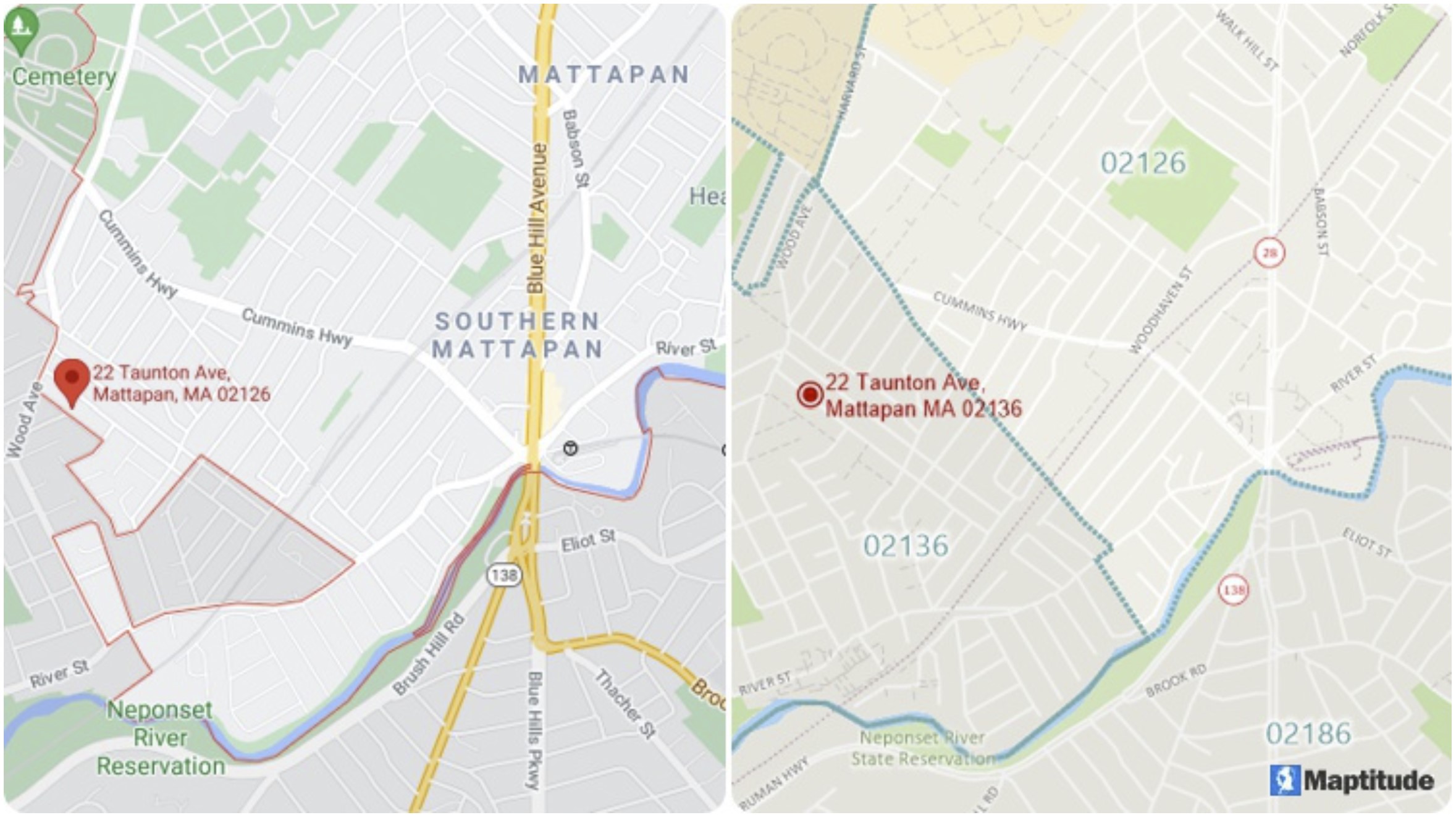
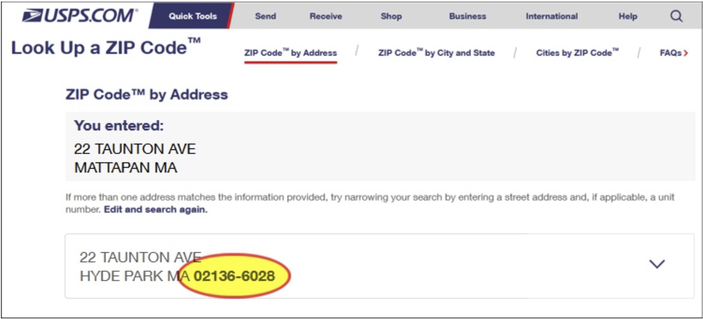
The Google map (top left) shows ZIP Code 02126 extending southwest whereas the Maptitude map (top right) and Zillow Neighborhoods show the correct boundaries. A USPS ZIP Code search for the address shows that the correct ZIP Code is 02136 (bottom).
What could have caused such an egregious error by Google, you ask? Well, the answer is not as straightforward as one might imagine and touches on important characteristics of ZIP Code areas that most people, including marketers, overlook or don’t understand. Such misunderstandings can impact comparisons of marketing data or sales territory definitions.
A ZIP Code is a five-digit numeric code that identifies a collection of mailing addresses within the United States, to simplify the distribution of mail by the United States Postal Service (USPS). Every ZIP Code can be shown as a point on a map. The point is located at the address of the post office for the ZIP Code or, if the ZIP Code can be shown as an area, at a central location inside the ZIP Code area.
Why the “if”? Only some ZIP Codes can be shown as areas. Many ZIP Codes do have delivery areas, and some ZIP Codes are for buildings or campuses that have defined borders. However, ZIP Codes are usually a list of addresses for delivering the mail. They are not, by definition, areas but are the street-based routes the mail carrier travels to deliver the mail to us. Boundaries can be created based on the location of addresses, but this is an approximation because carrier routes may overlap, and portions of the country have no deliverable addresses. To compound the difficulties in creating these areas, the ZIP Codes often do not adhere to the boundaries of cities, towns, counties, or states.
Consequently, ZIP Code definitions vary by the organization creating them, as highlighted by the odd Google Maps ZIP Code data above. Using ZIP Codes from different sources, even of the same vintage, can therefore have real world impacts, such as confusion over business counts. There are even once a decade ZIP Code approximations published by the Census Bureau called ZIP Code Tabulation Areas (ZCTAs), which are used for publishing decennial and ACS census data.
The Maptitude Team strives to create the best possible ZIP Code boundaries available. You can be confident in their accuracy and in the business decisions you make when using them. Maptitude includes current demographics and maps for 5-Digit and 3-Digit ZIP Code boundaries as well as a layer of 5-Digit ZIP Code points.